Percorso Marcia Remagen - Ahrsteig etappe 7 Rondwandeling 32km. - Photo

Ahrsteig etappe 7 Rondwandeling 32km.

 flip96
flip96

Utente

© OpenStreetMap contributors
Lunghezza
Lunghezza
31 km
Altitudine massima
Altitudine massima
217 m
Dislivello positivo
Dislivello positivo
640 m
Km-Effort
Km-Effort  
39 km
Altitudine minima
Altitudine minima
50 m
Dislivello negativo
Dislivello negativo
640 m
Boucle
Boucle
Sì
Data di creazione :
2014-12-10 00:00:00.0
Ultima modifica :
2014-12-10 00:00:00.0

(0 Recensione)

Marcia
Marcia
8h41
Difficoltà : Medio

Scannerizza questo codice QR per aprire il percorso nell'applicazione SityTrail

Applicazione GPS da escursionismo GRATUITA

Logo SityTrail SityTrail

IGN / Istituti geografici

Scarica SityTrail dall'App Store Scarica SityTrail da Google Play

Logo SityTrail SityTrail World

Il mondo è tuo

Scarica SityTrail dall'App Store Scarica SityTrail da Google Play Scarica SityTrail da Huawei AppGallery

Chi siamo

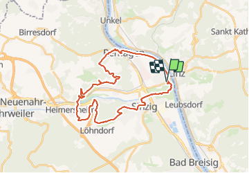
Percorso Marcia di 31 km da scoprire a Renania-Palatinato, Landkreis Ahrweiler, Remagen. Questo percorso è proposto da flip96.

Descrizione

Ahrsteig etappe 7 Rondwandeling.De laatste etappe van de Ahrsteig.
Weer een mooie met veel variatie. Ik heb de etappe doorgetrokken tot aan de Rijn. Voor de rondwandeling stukjes Rotweinwanderweg, Rheinburgenweg en een mooi stuk over de Rheinpromenade toegevoegd.
Opmerkingen? flip96@home.nl

Profilo altimetrico

Localizzazione

Paese:
Germany
Regione :
Renania-Palatinato
Dipartimento/Provincia :
Landkreis Ahrweiler
Comune :
Remagen
Località :
Unknown
Partenza:(Dec)
Partenza:(UTM)
377597 ; 5602436 (32U) N.

Percorsi nelle vicinanze

Percorso A piedi Bruchhausen - Rotbäckchen Rundwanderweg - Photo
A piedi
GUIDE+

A piedi

Facile
Bruchhausen, Renania-Palatinato, Landkreis Neuwied, Germany
11,1 km | 14,1 km-effort
3h 11min
Sì
Percorso A piedi Remagen - Apollinaris-Schleife (Rheinburgenweg Rundtour) - Photo
A piedi
GUIDE+

A piedi

Facile
Remagen, Renania-Palatinato, Landkreis Ahrweiler, Germany
12,7 km | 16,4 km-effort
3h 43min
Sì
Percorso A piedi Sinzig - Rundweg 7 Bad Bodendorf - Photo
A piedi
GUIDE+

A piedi

Facile
Sinzig, Renania-Palatinato, Landkreis Ahrweiler, Germany
8,8 km | 11,1 km-effort
2h 30min
Sì
Percorso A piedi Remagen - Wanderweg Remagen - Photo
A piedi
GUIDE+

A piedi

Facile
Remagen, Renania-Palatinato, Landkreis Ahrweiler, Germany
10 km | 13,8 km-effort
3h 7min
Sì
Percorso A piedi Remagen - DE-A3 - Photo
A piedi
GUIDE+

A piedi

Facile
Remagen, Renania-Palatinato, Landkreis Ahrweiler, Germany
4,7 km | 6,3 km-effort
1h 26min
Sì
Percorso A piedi Ockenfels - LZ15 - Rundwanderweg Ockenfels - Photo
A piedi
GUIDE+

A piedi

Facile
Ockenfels, Renania-Palatinato, Landkreis Neuwied, Germany
6,2 km | 8,1 km-effort
1h 51min
Sì
Percorso A piedi Linz am Rhein - LZ13 - Rundwanderweg Minderberg - Photo
A piedi
GUIDE+

A piedi

Facile
Linz am Rhein, Renania-Palatinato, Landkreis Neuwied, Germany
5,1 km | 7,2 km-effort
1h 37min
Sì
Percorso A piedi Sankt Katharinen - LZ9 - Rundwanderweg Lorscheid - Strödt - Photo
A piedi
GUIDE+

A piedi

Facile
Sankt Katharinen, Renania-Palatinato, Landkreis Neuwied, Germany
8,7 km | 11,6 km-effort
2h 38min
Sì
Percorso A piedi Sankt Katharinen - LZ8 - Rundwanderweg Hummelsberg - Photo
A piedi
GUIDE+

A piedi

Facile
Sankt Katharinen, Renania-Palatinato, Landkreis Neuwied, Germany
5,7 km | 7,2 km-effort
1h 38min
Sì


Chiudi
I miei abbonamenti