![](/images/other/stat-length.png)
![Percorso Marcia Bellecombe-en-Bauges - POINTE DE BANC PLAT - REPOSOIR - Photo](https://media.geolcdn.com/t/1900/400/ext.pjpeg?maxdim=2&url=https%3A%2F%2Fstatic1.geolcdn.com%2Fsiteimages%2Fupload%2Ffiles%2F1553511878bg_sport_marche.png)
POINTE DE BANC PLAT - REPOSOIR
sandra_leb
Utente
![Lunghezza](/images/other/stat-length.png)
![Altitudine massima](https://static1.geolcdn.com/siteimages/upload/files/1508320355ic_sort_altitude_max_24dp.png)
![Dislivello positivo](https://static1.geolcdn.com/siteimages/upload/files/1508320355ic_sort_den_pos_24dp.png)
![Km-Effort](/images/other/stat-length.png)
![Altitudine minima](https://static1.geolcdn.com/siteimages/upload/files/1508320355ic_sort_altitude_min_24dp.png)
![Dislivello negativo](https://static1.geolcdn.com/siteimages/upload/files/1508320355ic_sort_den_neg_24dp.png)
![Boucle](https://static1.geolcdn.com/siteimages/upload/files/16400158638029165_repeat_loop_refresh_sync_direction_icon.png)
![Marcia](https://static1.geolcdn.com/sitytour/trail-icons/101.png)
4h41
Difficoltà : Molto difficile
![Scannerizza questo codice QR per aprire il percorso nell'applicazione SityTrail](https://capi.geolives.com/qq0zvz2zws4bq2lad0pu/sitytour/trails/2464073/qr.png?size=200)
Applicazione GPS da escursionismo GRATUITA
Chi siamo
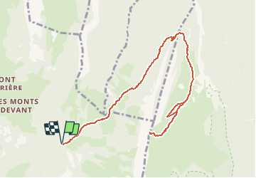
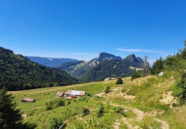
Percorso Marcia di 12,7 km da scoprire a Auvergne-Rhône-Alpes, Savoia, Bellecombe-en-Bauges. Questo percorso è proposto da sandra_leb.
Descrizione
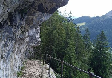
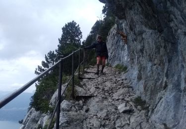
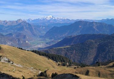
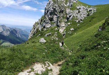
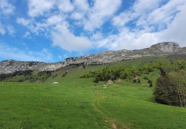
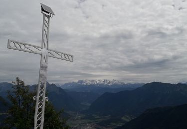
L'ascension depuis le Reposoir, lieu-dit de Bellecombe-en-Bauges, passe par le Col de Bornette pour emprunter aux Ailes du Nant, un sentier absent d'IGN. Le passage économise une centaine de mètres de dénivelé pour atteindre le pittoresque chemin de la Combe, taillé dans le rocher de la falaise pour offrir aux troupeaux un accès à l'alpage. Par le chalet-refuge de la Combe, une piste récente parcourt la Montagne du Charbon pour retrouver le vieux sentier qui donne accès aux pentes herbeuses sous le sommet de la Pointe de Banc Plat. Le retour se fait par le même itinéraire.
Localizzazione
Commenti
Percorsi nelle vicinanze
![Percorso Marcia Bellecombe-en-Bauges - Pointe de Banc Plat en boucle - Photo](https://media.geolcdn.com/t/375/260/80b75f38-16b0-40b8-9a99-ebc551fd27ff.jpg&format=jpg&maxdim=2)
![Marcia Marcia](https://static1.geolcdn.com/sitytour/trail-icons/101.png)
Marcia
![](/images/other/stat-length.png)
![](https://static1.geolcdn.com/siteimages/upload/files/16400158638029165_repeat_loop_refresh_sync_direction_icon.png)
![Percorso Sci alpinismo Bellecombe-en-Bauges - la dent des portes et sous le Trelod - Photo](https://media.geolcdn.com/t/375/260/5df2df97-f7db-4fea-9d78-8be71e3fb466.jpg&format=jpg&maxdim=2)
![Sci alpinismo Sci alpinismo](https://static1.geolcdn.com/sitytour/trail-icons/503.png)
Sci alpinismo
![](/images/other/stat-length.png)
![](https://static1.geolcdn.com/siteimages/upload/files/16400158638029165_repeat_loop_refresh_sync_direction_icon.png)
![Percorso Marcia Bellecombe-en-Bauges - Banc plat boucle - Photo](https://media.geolcdn.com/t/375/260/a2db89fd-d92b-448f-a4ef-41a90ffed31c.jpg&format=jpg&maxdim=2)
![Marcia Marcia](https://static1.geolcdn.com/sitytour/trail-icons/101.png)
Marcia
![](/images/other/stat-length.png)
![](https://static1.geolcdn.com/siteimages/upload/files/16400158638029165_repeat_loop_refresh_sync_direction_icon.png)
![Percorso Marcia Doucy-en-Bauges - 2015-09-11 Marche Mont Trelod - Photo](https://media.geolcdn.com/t/375/260/ext.jpg?maxdim=2&url=https%3A%2F%2Fstatic1.geolcdn.com%2Fsiteimages%2Fupload%2Ffiles%2F1553511878bg_sport_marche.png)
![Marcia Marcia](https://static1.geolcdn.com/sitytour/trail-icons/101.png)
Marcia
![](/images/other/stat-length.png)
![](https://static1.geolcdn.com/siteimages/upload/files/16400158638029165_repeat_loop_refresh_sync_direction_icon.png)
![Percorso Marcia Bellecombe-en-Bauges - BAUGES: BANC PLAT via REPOSOIR - BORNETTE - REFUGE COMBE - Photo](https://media.geolcdn.com/t/375/260/e352fcdc-17f0-46fd-b7a7-5ac4f4bb5365.jpg&format=jpg&maxdim=2)
![Marcia Marcia](https://static1.geolcdn.com/sitytour/trail-icons/101.png)
Marcia
![](/images/other/stat-length.png)
![](https://static1.geolcdn.com/siteimages/upload/files/16400158638029165_repeat_loop_refresh_sync_direction_icon.png)
![Percorso Marcia Bellecombe-en-Bauges - Dent des portes e Mont Trelod - Photo](https://media.geolcdn.com/t/375/260/b0c4b228-1140-4be2-bd7d-dd2d9637b851.jpg&format=jpg&maxdim=2)
![Marcia Marcia](https://static1.geolcdn.com/sitytour/trail-icons/101.png)
Marcia
![](/images/other/stat-length.png)
![](https://static1.geolcdn.com/siteimages/upload/files/16400158638029165_repeat_loop_refresh_sync_direction_icon.png)
![Percorso Marcia Doucy-en-Bauges - 250524 Le Trelod et la Dents des Portes - Photo](https://media.geolcdn.com/t/375/260/4afdb455-3922-47f1-8f79-e9d92dd0333d.jpg&format=jpg&maxdim=2)
![Marcia Marcia](https://static1.geolcdn.com/sitytour/trail-icons/101.png)
Marcia
![](/images/other/stat-length.png)
![](https://static1.geolcdn.com/siteimages/upload/files/16400158638029165_repeat_loop_refresh_sync_direction_icon.png)
![Percorso Marcia Bellecombe-en-Bauges - La croix du Roy - Photo](https://media.geolcdn.com/t/375/260/f0613759-db59-4826-869f-3a31d0a833ec.jpg&format=jpg&maxdim=2)
![Marcia Marcia](https://static1.geolcdn.com/sitytour/trail-icons/101.png)
Marcia
![](/images/other/stat-length.png)
![](https://static1.geolcdn.com/siteimages/upload/files/16400158638029165_repeat_loop_refresh_sync_direction_icon.png)
![Percorso Marcia Bellecombe-en-Bauges - Tour de BancPlat, Dent des portes en partant du petit reposoir - Photo](https://media.geolcdn.com/t/375/260/81d53e38-45e7-40ed-845e-f728822d5f43.jpg&format=jpg&maxdim=2)
![Marcia Marcia](https://static1.geolcdn.com/sitytour/trail-icons/101.png)
Marcia
![](/images/other/stat-length.png)
![](https://static1.geolcdn.com/siteimages/upload/files/16400158638029165_repeat_loop_refresh_sync_direction_icon.png)