![](/images/other/stat-length.png)
![Percorso Marcia Brakel - Everbeek/Brakel: Haeyesbos - Livierenbos - Maandagkouter - Photo](https://media.geolcdn.com/t/1900/400/24cd8ff7-753f-43db-aaac-1a041cd70be1.jpg&format=pjpeg&maxdim=2)
Everbeek/Brakel: Haeyesbos - Livierenbos - Maandagkouter
koen.steenhoudt
Utente
![Lunghezza](/images/other/stat-length.png)
![Altitudine massima](https://static1.geolcdn.com/siteimages/upload/files/1508320355ic_sort_altitude_max_24dp.png)
![Dislivello positivo](https://static1.geolcdn.com/siteimages/upload/files/1508320355ic_sort_den_pos_24dp.png)
![Km-Effort](/images/other/stat-length.png)
![Altitudine minima](https://static1.geolcdn.com/siteimages/upload/files/1508320355ic_sort_altitude_min_24dp.png)
![Dislivello negativo](https://static1.geolcdn.com/siteimages/upload/files/1508320355ic_sort_den_neg_24dp.png)
![Boucle](https://static1.geolcdn.com/siteimages/upload/files/16400158638029165_repeat_loop_refresh_sync_direction_icon.png)
![Marcia](https://static1.geolcdn.com/sitytour/trail-icons/101.png)
1h31
Difficoltà : Medio
![Scannerizza questo codice QR per aprire il percorso nell'applicazione SityTrail](https://capi.geolives.com/qq0zvz2zws4bq2lad0pu/sitytour/trails/2250896/qr.png?size=200)
Applicazione GPS da escursionismo GRATUITA
Chi siamo
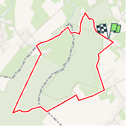
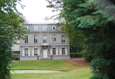
Percorso Marcia di 4,4 km da scoprire a Vlaanderen, Provincia delle Fiandre Orientali, Brakel. Questo percorso è proposto da koen.steenhoudt.
Descrizione
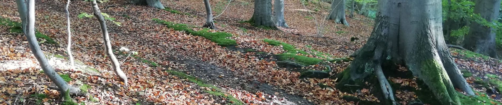
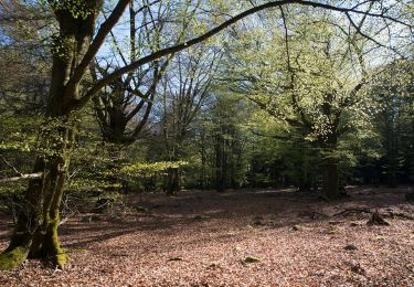
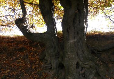
Not more than 4,5 km but with all ingredients of the Flemish Ardens: majestic beech trees and forest lanes, relief changes, freaking creek valleys and ropey landscapes ... and in spring - naturally - the eye catching carpets of white anemones and blue hyacinths.
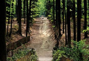
Park the car near the corner of Kroonstraat with Hoogbos at Everbeek-Boven. Enter Haeyesbos. At node 86, leave the steep descent at your left, and go to the right. Make a wide turn along a beautiful hollow forest path and alongside an old chapel. After the white house, turn to the left, leaving the node network for a moment. At the next junction, turn to the right, cross the wooden bridge en follow a scenic path along the edge of a ropey meadow. At the next junction (node 87) turn left and follow a short lane bordered by hedges. This lane continues into the long majestic lane through Livierenbos, which you follow for 1 km, until node 35. Turn right en follow a small, winding path through a steep creek valley. A short climb brings you at the edge of Maandagkouter. Follow the edge of forest and farmland until a small paved road. Turn right and follow this road for 500 m, leaving node 36 at your right. Turn left, into a field track, following node 3, which you already reach after 100 m. Continue in the direction of node 86. After open farmland with a view on the southern edge of Haeyesbos, you are back at the starting point.
Localizzazione
Commenti
Percorsi nelle vicinanze
![Percorso Marcia Flobecq - Flobecq, Natura 2000 des sites qui valent le détour. Ht10 - Photo](https://media.geolcdn.com/t/375/260/ext.jpg?maxdim=2&url=https%3A%2F%2Fservices.sitytrail.com%2FGeolivesWS%2FDownloadMedia.ashx%3FTrailID%3D909698%26Media%3D35121b2c-4aba-47c4-9fcc-6708631a1f90.jpg)
![Marcia Marcia](https://static1.geolcdn.com/sitytour/trail-icons/101.png)
Marcia
![](/images/other/stat-length.png)
![](https://static1.geolcdn.com/siteimages/upload/files/16400158638029165_repeat_loop_refresh_sync_direction_icon.png)
![Percorso A piedi Brakel - Everbeekpad - Photo](https://media.geolcdn.com/t/375/260/d08ad0f4-de55-4764-95c5-9e3d60aacb5d.jpeg&format=jpg&maxdim=2)
![A piedi A piedi](https://static1.geolcdn.com/sitytour/trail-icons/100.png)
A piedi
![](/images/other/stat-length.png)
![](https://static1.geolcdn.com/siteimages/upload/files/16400158638029165_repeat_loop_refresh_sync_direction_icon.png)
![Percorso A piedi Brakel - Toeppad - Photo](https://media.geolcdn.com/t/375/260/09e5ced1-9302-45ec-a2ea-0bc749e41ee5.jpeg&format=jpg&maxdim=2)
![A piedi A piedi](https://static1.geolcdn.com/sitytour/trail-icons/100.png)
A piedi
![](/images/other/stat-length.png)
![](https://static1.geolcdn.com/siteimages/upload/files/16400158638029165_repeat_loop_refresh_sync_direction_icon.png)
![Percorso A piedi Brakel - Tweebossenpad - Photo](https://media.geolcdn.com/t/375/260/0ea6d16c-e6be-4ad6-877d-eae169d349af.jpeg&format=jpg&maxdim=2)
![A piedi A piedi](https://static1.geolcdn.com/sitytour/trail-icons/100.png)
A piedi
![](/images/other/stat-length.png)
![](https://static1.geolcdn.com/siteimages/upload/files/16400158638029165_repeat_loop_refresh_sync_direction_icon.png)
![Percorso A piedi Flobecq - Entre La Houppe et Bos Ter Rijst - Photo](https://media.geolcdn.com/t/375/260/ext.jpg?maxdim=2&url=https%3A%2F%2Fpivotmedia.tourismewallonie.be%2FANX-02-000EUQ%2FANX-02-000EUQ.jpg)
![A piedi A piedi](https://static1.geolcdn.com/sitytour/trail-icons/100.png)
A piedi
![](/images/other/stat-length.png)
![](https://static1.geolcdn.com/siteimages/upload/files/16400158638029165_repeat_loop_refresh_sync_direction_icon.png)
![Percorso Cavallo Flobecq - Loop of Flobecq - Photo](https://media.geolcdn.com/t/375/260/ext.jpg?maxdim=2&url=https%3A%2F%2Fpivotmedia.tourismewallonie.be%2FANX-02-000EIV%2FANX-02-000EIV.jpg)
![Cavallo Cavallo](https://static1.geolcdn.com/sitytour/trail-icons/300.png)
Cavallo
![](/images/other/stat-length.png)
![](https://static1.geolcdn.com/siteimages/upload/files/16400158638029165_repeat_loop_refresh_sync_direction_icon.png)
![Percorso A piedi Flobecq - The Medicinal Plants Walking Tour - Photo](https://media.geolcdn.com/t/375/260/ext.jpg?maxdim=2&url=https%3A%2F%2Fpivotmedia.tourismewallonie.be%2FANX-02-03MU-01W7%2FANX-02-03MU-01W7.jpg)
![A piedi A piedi](https://static1.geolcdn.com/sitytour/trail-icons/100.png)
A piedi
![](/images/other/stat-length.png)
![](https://static1.geolcdn.com/siteimages/upload/files/16400158638029165_repeat_loop_refresh_sync_direction_icon.png)
![Percorso A piedi Flobecq - Dans le Brakelbos - Photo](https://media.geolcdn.com/t/375/260/ext.jpg?maxdim=2&url=https%3A%2F%2Fpivotmedia.tourismewallonie.be%2FANX-02-000EUU%2FANX-02-000EUU.jpg)
![A piedi A piedi](https://static1.geolcdn.com/sitytour/trail-icons/100.png)
A piedi
![](/images/other/stat-length.png)
![](https://static1.geolcdn.com/siteimages/upload/files/16400158638029165_repeat_loop_refresh_sync_direction_icon.png)
![Percorso A piedi Flobecq - Entre Everbeek-Boven et le Bois de la Louvière - Photo](https://media.geolcdn.com/t/375/260/ext.jpg?maxdim=2&url=https%3A%2F%2Fpivotmedia.tourismewallonie.be%2FANX-02-000EUY%2FANX-02-000EUY.jpg)
![A piedi A piedi](https://static1.geolcdn.com/sitytour/trail-icons/100.png)
A piedi
![](/images/other/stat-length.png)
![](https://static1.geolcdn.com/siteimages/upload/files/16400158638029165_repeat_loop_refresh_sync_direction_icon.png)