![](/images/other/stat-length.png)
![Percorso Cicloturismo Saint-Pé-de-Bigorre - St-Pé-de-Bigorre - Oloron - Photo](https://media.geolcdn.com/t/1900/400/739f813a-904d-451b-8157-1a9c53e28555.jpg&format=pjpeg&maxdim=2)
St-Pé-de-Bigorre - Oloron
karawatsj
Utente
![Lunghezza](/images/other/stat-length.png)
![Altitudine massima](https://static1.geolcdn.com/siteimages/upload/files/1508320355ic_sort_altitude_max_24dp.png)
![Dislivello positivo](https://static1.geolcdn.com/siteimages/upload/files/1508320355ic_sort_den_pos_24dp.png)
![Km-Effort](/images/other/stat-length.png)
![Altitudine minima](https://static1.geolcdn.com/siteimages/upload/files/1508320355ic_sort_altitude_min_24dp.png)
![Dislivello negativo](https://static1.geolcdn.com/siteimages/upload/files/1508320355ic_sort_den_neg_24dp.png)
![Boucle](https://static1.geolcdn.com/siteimages/upload/files/16400158638029165_repeat_loop_refresh_sync_direction_icon.png)
![Cicloturismo](https://static1.geolcdn.com/sitytour/trail-icons/204.png)
3h54
Difficoltà : Difficile
![Scannerizza questo codice QR per aprire il percorso nell'applicazione SityTrail](https://capi.geolives.com/qq0zvz2zws4bq2lad0pu/sitytour/trails/2130396/qr.png?size=200)
Applicazione GPS da escursionismo GRATUITA
Chi siamo
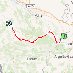
Percorso Cicloturismo di 62 km da scoprire a Occitania, Alti-Pirenei, Saint-Pé-de-Bigorre. Questo percorso è proposto da karawatsj.
Descrizione
We steken de Pau over die we volgen tot in Nay. Hier verlaten we de Pau en stijgen naar een golvend plateau tussen Gave de Pau en Gave d'Ossau. Eventjes flink klimmen.
Er is lage bewolking maar hier en daar komt toch de zon te voorschijn. De hoogste bergtoppen blijven verborgen. Mooi, ontspannend en uitermate rustig fietsen.
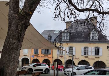
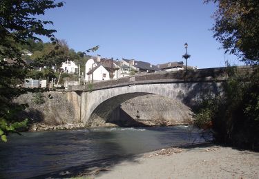
We dalen af naar Arudy. We steken de Gave d'Ossau over en rijden naar het centrum met gezellig stadspleintje. Een frisdrankje en even rust. We volgen de Ossau nog even maar dan stijgen we terug en klimmen door het prachtige Bois du Bager naar een col waar we onze casse-croûte nemen op een bankje nabij een boshut. Als we het bos uitrijden bevinden we ons op de rue des crêtes. De lucht is gedeeltelijk opgeklaard en ver weg kunnen we besneeuwde bergtoppen ontwaren.
Wat later dalen we terug af naar Oloron.
Localizzazione
Commenti
Percorsi nelle vicinanze
![Percorso Marcia Lestelle-Bétharram - Lestelle les grottes G4 - Photo](https://media.geolcdn.com/t/375/260/7f7b50d2-f2bb-47c5-8f12-711bf0f3d7e6.jpg&format=jpg&maxdim=2)
![Marcia Marcia](https://static1.geolcdn.com/sitytour/trail-icons/101.png)
Marcia
![](/images/other/stat-length.png)
![](https://static1.geolcdn.com/siteimages/upload/files/16400158638029165_repeat_loop_refresh_sync_direction_icon.png)
![Percorso A piedi Saint-Pé-de-Bigorre - SAINT PE DE BIGORRE Le grand tour de saint pe](https://media.geolcdn.com/t/375/260/d4e35e12-fcd4-45d8-ab2c-c6eef77cd69d.jpg&format=jpg&maxdim=2)
![A piedi A piedi](https://static1.geolcdn.com/sitytour/trail-icons/100.png)
A piedi
![](/images/other/stat-length.png)
![](https://static1.geolcdn.com/siteimages/upload/files/16400158638029165_repeat_loop_refresh_sync_direction_icon.png)
![Percorso A piedi Saint-Pé-de-Bigorre - Le Plateau du Mousqué - Photo](https://media.geolcdn.com/t/375/260/42583d43-4f8c-4618-a872-ff80c3533f76.jpeg&format=jpg&maxdim=2)
![A piedi A piedi](https://static1.geolcdn.com/sitytour/trail-icons/100.png)
A piedi
![](/images/other/stat-length.png)
![](https://static1.geolcdn.com/siteimages/upload/files/16400158638029165_repeat_loop_refresh_sync_direction_icon.png)
![Percorso A piedi Peyrouse - Le Chemin du Bédouret - Photo](https://media.geolcdn.com/t/375/260/410ed0c7-f304-4562-a01b-d18ec14f94a1.jpeg&format=jpg&maxdim=2)
![A piedi A piedi](https://static1.geolcdn.com/sitytour/trail-icons/100.png)
A piedi
![](/images/other/stat-length.png)
![](https://static1.geolcdn.com/siteimages/upload/files/16400158638029165_repeat_loop_refresh_sync_direction_icon.png)
![Percorso A piedi Saint-Pé-de-Bigorre - Lengous et Montagnou - Photo](https://media.geolcdn.com/t/375/260/3d171576-7edb-45cf-8fd4-ef8c6e3c3bb3.jpeg&format=jpg&maxdim=2)
![A piedi A piedi](https://static1.geolcdn.com/sitytour/trail-icons/100.png)
A piedi
![](/images/other/stat-length.png)
![](https://static1.geolcdn.com/siteimages/upload/files/16400158638029165_repeat_loop_refresh_sync_direction_icon.png)
![Percorso A piedi Saint-Pé-de-Bigorre - Les Coteaux de Saint-Pé - Photo](https://media.geolcdn.com/t/375/260/a489e4e4-1a5e-4103-b616-7e0cacda4ef5.jpeg&format=jpg&maxdim=2)
![A piedi A piedi](https://static1.geolcdn.com/sitytour/trail-icons/100.png)
A piedi
![](/images/other/stat-length.png)
![](https://static1.geolcdn.com/siteimages/upload/files/16400158638029165_repeat_loop_refresh_sync_direction_icon.png)
![Percorso Marcia Saint-Pé-de-Bigorre - SAINT PE de BIGORRE et ses côteaux G4 faite avec LPC](https://media.geolcdn.com/t/375/260/80dcc544-2fa3-498d-9bdc-669b61c91573.jpg&format=jpg&maxdim=2)
![Marcia Marcia](https://static1.geolcdn.com/sitytour/trail-icons/101.png)
Marcia
![](/images/other/stat-length.png)
![](https://static1.geolcdn.com/siteimages/upload/files/16400158638029165_repeat_loop_refresh_sync_direction_icon.png)
![Percorso Marcia Saint-Pé-de-Bigorre - Les Soums Saint-Péens - Saint Pé de Bigorre - Photo](https://media.geolcdn.com/t/375/260/ext.jpg?maxdim=2&url=https%3A%2F%2Fstatic1.geolcdn.com%2Fsiteimages%2Fupload%2Ffiles%2F1553511878bg_sport_marche.png)
![Marcia Marcia](https://static1.geolcdn.com/sitytour/trail-icons/101.png)
Marcia
![](/images/other/stat-length.png)
![](https://static1.geolcdn.com/siteimages/upload/files/16400158638029165_repeat_loop_refresh_sync_direction_icon.png)
![Percorso Marcia Lestelle-Bétharram - 2023 10 10 CHEMIN du PIÉMONT PYRÉNÉEN - 18ème étape : Lestelle-Bétharram - Asson - Bruges - Mifaget - Ste Colome - Arudy - Photo](https://media.geolcdn.com/t/375/260/cf775eff-bc3f-4ffa-8e7c-bf58d3fbf382.jpg&format=jpg&maxdim=2)
![Marcia Marcia](https://static1.geolcdn.com/sitytour/trail-icons/101.png)
Marcia
![](/images/other/stat-length.png)
![](https://static1.geolcdn.com/siteimages/upload/files/16400158638029165_repeat_loop_refresh_sync_direction_icon.png)