![](/images/other/stat-length.png)
![Percorso Mountainbike La Ferrière-aux-Étangs - Autour de Banvou - Photo](https://media.geolcdn.com/t/1900/400/ext.pjpeg?maxdim=2&url=https%3A%2F%2Fstatic1.geolcdn.com%2Fsiteimages%2Fupload%2Ffiles%2F1524743154velo.jpg)
Autour de Banvou
tracegps
Utente
![Lunghezza](/images/other/stat-length.png)
Lunghezza
32 km
![Altitudine massima](https://static1.geolcdn.com/siteimages/upload/files/1508320355ic_sort_altitude_max_24dp.png)
Altitudine massima
301 m
![Dislivello positivo](https://static1.geolcdn.com/siteimages/upload/files/1508320355ic_sort_den_pos_24dp.png)
Dislivello positivo
503 m
![Km-Effort](/images/other/stat-length.png)
Km-Effort
39 km
![Altitudine minima](https://static1.geolcdn.com/siteimages/upload/files/1508320355ic_sort_altitude_min_24dp.png)
Altitudine minima
154 m
![Dislivello negativo](https://static1.geolcdn.com/siteimages/upload/files/1508320355ic_sort_den_neg_24dp.png)
Dislivello negativo
503 m
![Boucle](https://static1.geolcdn.com/siteimages/upload/files/16400158638029165_repeat_loop_refresh_sync_direction_icon.png)
Boucle
Sì
Data di creazione :
2014-12-10 00:00:00.0
Ultima modifica :
2014-12-10 00:00:00.0
![Mountainbike](https://static1.geolcdn.com/sitytour/trail-icons/202.png)
2h30
Difficoltà : Medio
![Scannerizza questo codice QR per aprire il percorso nell'applicazione SityTrail](https://capi.geolives.com/qq0zvz2zws4bq2lad0pu/sitytour/trails/102965/qr.png?size=200)
Applicazione GPS da escursionismo GRATUITA
Chi siamo
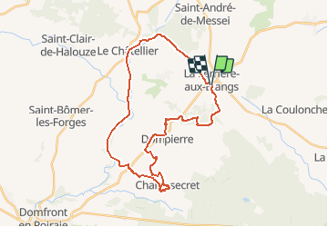
Percorso Mountainbike di 32 km da scoprire a Normandia, Orne, La Ferrière-aux-Étangs. Questo percorso è proposto da tracegps.
Descrizione
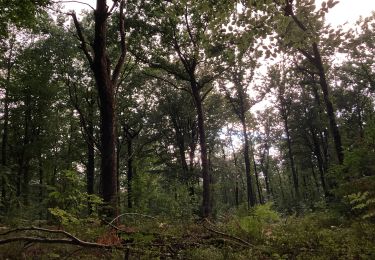
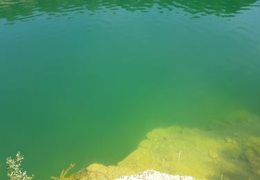
Boucle autour de Banvou. Point de Départ : dans le centre de La Ferrière aux Etangs, sur la digue en bout du plan d'eau. Parcourt varié alternant sous bois, chemins creux du bocage, Voie Verte et chemin en lisière de foret.
Localizzazione
Paese:
France
Regione :
Normandia
Dipartimento/Provincia :
Orne
Comune :
La Ferrière-aux-Étangs
Località :
Unknown
Partenza:(Dec)
Partenza:(UTM)
682721 ; 5392603 (30U) N.
Commenti
Percorsi nelle vicinanze
![Percorso Marcia La Ferrière-aux-Étangs - Circuit of IRON by Yannick-p14-61 - Photo](https://media.geolcdn.com/t/375/260/e9109058-b6fa-4ee9-9d84-e1a504225bdf.jpg&format=jpg&maxdim=2)
![Marcia Marcia](https://static1.geolcdn.com/sitytour/trail-icons/101.png)
Circuit of IRON by Yannick-p14-61
Marcia
Medio
(1)
La Ferrière-aux-Étangs,
Normandia,
Orne,
France
![](/images/other/stat-length.png)
13,3 km | 16,5 km-effort
3h 35min
![](https://static1.geolcdn.com/siteimages/upload/files/16400158638029165_repeat_loop_refresh_sync_direction_icon.png)
Sì
![Percorso Marcia La Coulonche - La coulonche - Photo](https://media.geolcdn.com/t/375/260/95c3eac8-30e6-4fa2-8846-ef805e476c7d.jpg&format=jpg&maxdim=2)
![Marcia Marcia](https://static1.geolcdn.com/sitytour/trail-icons/101.png)
La coulonche
Marcia
Molto facile
La Coulonche,
Normandia,
Orne,
France
![](/images/other/stat-length.png)
3,7 km | 4,9 km-effort
1h 22min
![](https://static1.geolcdn.com/siteimages/upload/files/16400158638029165_repeat_loop_refresh_sync_direction_icon.png)
Sì
![Percorso Marcia La Ferrière-aux-Étangs - La Ferrière - La Ferrière aux Etangs - Photo](https://media.geolcdn.com/t/375/260/ext.jpg?maxdim=2&url=https%3A%2F%2Fservices.sitytrail.com%2FGeolivesWS%2FDownloadMedia.ashx%3FTrailID%3D111661%26Media%3D7899_2.jpg)
![Marcia Marcia](https://static1.geolcdn.com/sitytour/trail-icons/101.png)
La Ferrière - La Ferrière aux Etangs
Marcia
Medio
La Ferrière-aux-Étangs,
Normandia,
Orne,
France
![](/images/other/stat-length.png)
14,3 km | 17,9 km-effort
3h 4min
![](https://static1.geolcdn.com/siteimages/upload/files/16400158638029165_repeat_loop_refresh_sync_direction_icon.png)
Sì
![Percorso Marcia La Ferrière-aux-Étangs - 1h16 - Photo](https://media.geolcdn.com/t/375/260/30fe1b0a-da55-41f8-8ede-6b74633fdbd3.jpg&format=jpg&maxdim=2)
![Marcia Marcia](https://static1.geolcdn.com/sitytour/trail-icons/101.png)
1h16
Marcia
Medio
La Ferrière-aux-Étangs,
Normandia,
Orne,
France
![](/images/other/stat-length.png)
6,4 km | 8,5 km-effort
1h 16min
![](https://static1.geolcdn.com/siteimages/upload/files/16400158638029165_repeat_loop_refresh_sync_direction_icon.png)
Sì
![Percorso Marcia Le Châtellier - chatellier - Photo](https://media.geolcdn.com/t/375/260/ext.jpg?maxdim=2&url=https%3A%2F%2Fstatic1.geolcdn.com%2Fsiteimages%2Fupload%2Ffiles%2F1553511878bg_sport_marche.png)
![Marcia Marcia](https://static1.geolcdn.com/sitytour/trail-icons/101.png)
![Percorso Marcia Dompierre - mines - Photo](https://media.geolcdn.com/t/375/260/ext.jpg?maxdim=2&url=https%3A%2F%2Fstatic1.geolcdn.com%2Fsiteimages%2Fupload%2Ffiles%2F1553511878bg_sport_marche.png)
![Marcia Marcia](https://static1.geolcdn.com/sitytour/trail-icons/101.png)
![Percorso Marcia La Ferrière-aux-Étangs - La Feriere aux etant - Photo](https://media.geolcdn.com/t/375/260/f76f6a14-4f12-4d3c-ba5b-00c3b8cd2d26.jpg&format=jpg&maxdim=2)
![Marcia Marcia](https://static1.geolcdn.com/sitytour/trail-icons/101.png)
La Feriere aux etant
Marcia
Molto facile
La Ferrière-aux-Étangs,
Normandia,
Orne,
France
![](/images/other/stat-length.png)
1,2 km | 1,3 km-effort
36min
![](https://static1.geolcdn.com/siteimages/upload/files/16400158638029165_repeat_loop_refresh_sync_direction_icon.png)
Sì
![Percorso Marcia Dompierre - Dompierre; trace GPS du 10/09/2019 - Photo](https://media.geolcdn.com/t/375/260/ext.jpg?maxdim=2&url=https%3A%2F%2Fstatic1.geolcdn.com%2Fsiteimages%2Fupload%2Ffiles%2F1553511878bg_sport_marche.png)
![Marcia Marcia](https://static1.geolcdn.com/sitytour/trail-icons/101.png)
Dompierre; trace GPS du 10/09/2019
Marcia
Molto facile
Dompierre,
Normandia,
Orne,
France
![](/images/other/stat-length.png)
8,2 km | 10,2 km-effort
4h 30min
![](https://static1.geolcdn.com/siteimages/upload/files/16400158638029165_repeat_loop_refresh_sync_direction_icon.png)
Sì
![Percorso Marcia Dompierre - Dompierre longue - Photo](https://media.geolcdn.com/t/375/260/ext.jpg?maxdim=2&url=https%3A%2F%2Fstatic1.geolcdn.com%2Fsiteimages%2Fupload%2Ffiles%2F1553511878bg_sport_marche.png)
![Marcia Marcia](https://static1.geolcdn.com/sitytour/trail-icons/101.png)