![](/images/other/stat-length.png)
- Percorsi
- Outdoor
- France
- Provenza-Alpi-Costa Azzurra
- Var
- Aiguines
Aiguines, Var : I migliori sentieri, percorsi e passeggiate
Aiguines: Scopri i migliori percorsi: 79 percorsi a piedi e 4 percorsi in bicicletta o MTB. Tutti questi percorsi, itinerari e attività outdoor sono disponibili nelle nostre app SityTrail per smartphone e tablet.
I percorsi migliori (0})
![Percorso Marcia Aiguines - Belvédère, gorges, Inbut, sentier Vidal - Photo](https://media.geolcdn.com/t/350/260/ext.jpg?maxdim=2&url=https%3A%2F%2Fservices.sitytrail.com%2FGeolivesWS%2FDownloadMedia.ashx%3FTrailID%3D285198%26Media%3Dfix__20140510140144.jpg)
![Marcia Marcia](https://static1.geolcdn.com/sitytour/trail-icons/101.png)
Km
Marcia
![](/images/other/stat-length.png)
![](https://static1.geolcdn.com/siteimages/upload/files/1508320355ic_sort_den_pos_24dp.png)
![](https://static1.geolcdn.com/siteimages/upload/files/1508320355ic_sort_den_neg_24dp.png)
![](https://static1.geolcdn.com/siteimages/upload/files/16400158638029165_repeat_loop_refresh_sync_direction_icon.png)
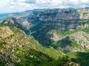
• Boucle à partir du Belvédère. Parcours aérien avec des passages équipés dans les gorges et lors de la remontée par le...
![Percorso Marcia Aiguines - Verdon - Aiguines - Mont Margès - Photo](https://media.geolcdn.com/t/350/260/ext.jpg?maxdim=2&url=https%3A%2F%2Fstatic1.geolcdn.com%2Fsiteimages%2Fupload%2Ffiles%2F1553511878bg_sport_marche.png)
![Marcia Marcia](https://static1.geolcdn.com/sitytour/trail-icons/101.png)
Km
Marcia
![](/images/other/stat-length.png)
![](https://static1.geolcdn.com/siteimages/upload/files/1508320355ic_sort_den_pos_24dp.png)
![](https://static1.geolcdn.com/siteimages/upload/files/1508320355ic_sort_den_neg_24dp.png)
![](https://static1.geolcdn.com/siteimages/upload/files/16400158638029165_repeat_loop_refresh_sync_direction_icon.png)
![Percorso Marcia Aiguines - 25-07-2023 Le Grand Margès retour par le cirque de Vaumale - Photo](https://media.geolcdn.com/t/350/260/636d8cc5-7aa8-4cca-9c55-e40a8cd11367.jpg&format=jpg&maxdim=2)
![Marcia Marcia](https://static1.geolcdn.com/sitytour/trail-icons/101.png)
Km
Marcia
![](/images/other/stat-length.png)
![](https://static1.geolcdn.com/siteimages/upload/files/1508320355ic_sort_den_pos_24dp.png)
![](https://static1.geolcdn.com/siteimages/upload/files/1508320355ic_sort_den_neg_24dp.png)
![](https://static1.geolcdn.com/siteimages/upload/files/16400158638029165_repeat_loop_refresh_sync_direction_icon.png)
![Percorso Marcia Aiguines - Grand Marges Gorges Verdon réel - Photo](https://media.geolcdn.com/t/350/260/a9c9c5a2-d843-460d-8768-728b79cb705c.jpg&format=jpg&maxdim=2)
![Marcia Marcia](https://static1.geolcdn.com/sitytour/trail-icons/101.png)
Km
Marcia
![](/images/other/stat-length.png)
![](https://static1.geolcdn.com/siteimages/upload/files/1508320355ic_sort_den_pos_24dp.png)
![](https://static1.geolcdn.com/siteimages/upload/files/1508320355ic_sort_den_neg_24dp.png)
![](https://static1.geolcdn.com/siteimages/upload/files/16400158638029165_repeat_loop_refresh_sync_direction_icon.png)
![Percorso Marcia Aiguines - Sentier de l'Imbut -Sentier Vidal - Photo](https://media.geolcdn.com/t/350/260/24ef0bc9-f073-44dd-a7de-d11489422dcc.jpg&format=jpg&maxdim=2)
![Marcia Marcia](https://static1.geolcdn.com/sitytour/trail-icons/101.png)
Km
Marcia
![](/images/other/stat-length.png)
![](https://static1.geolcdn.com/siteimages/upload/files/1508320355ic_sort_den_pos_24dp.png)
![](https://static1.geolcdn.com/siteimages/upload/files/1508320355ic_sort_den_neg_24dp.png)
![](https://static1.geolcdn.com/siteimages/upload/files/16400158638029165_repeat_loop_refresh_sync_direction_icon.png)
![Percorso Marcia Aiguines - aiguines - Photo](https://media.geolcdn.com/t/350/260/ext.jpg?maxdim=2&url=https%3A%2F%2Fstatic1.geolcdn.com%2Fsiteimages%2Fupload%2Ffiles%2F1553511878bg_sport_marche.png)
![Marcia Marcia](https://static1.geolcdn.com/sitytour/trail-icons/101.png)
Km
Marcia
![](/images/other/stat-length.png)
![](https://static1.geolcdn.com/siteimages/upload/files/1508320355ic_sort_den_pos_24dp.png)
![](https://static1.geolcdn.com/siteimages/upload/files/1508320355ic_sort_den_neg_24dp.png)
![](https://static1.geolcdn.com/siteimages/upload/files/16400158638029165_repeat_loop_refresh_sync_direction_icon.png)
•
![Percorso Marcia Aiguines - sentier de l'imbut par les cavaliers - Photo](https://media.geolcdn.com/t/350/260/928875a7-59ee-428f-a9c3-62319c041f01.jpg&format=jpg&maxdim=2)
![Marcia Marcia](https://static1.geolcdn.com/sitytour/trail-icons/101.png)
Km
Marcia
![](/images/other/stat-length.png)
![](https://static1.geolcdn.com/siteimages/upload/files/1508320355ic_sort_den_pos_24dp.png)
![](https://static1.geolcdn.com/siteimages/upload/files/1508320355ic_sort_den_neg_24dp.png)
![](https://static1.geolcdn.com/siteimages/upload/files/16400158638029165_repeat_loop_refresh_sync_direction_icon.png)
![Percorso Marcia Aiguines - aiguine. du galetas à aiguine - Photo](https://media.geolcdn.com/t/350/260/ace5469d-1226-494f-802d-984a616b105b.jpg&format=jpg&maxdim=2)
![Marcia Marcia](https://static1.geolcdn.com/sitytour/trail-icons/101.png)
Km
Marcia
![](/images/other/stat-length.png)
![](https://static1.geolcdn.com/siteimages/upload/files/1508320355ic_sort_den_pos_24dp.png)
![](https://static1.geolcdn.com/siteimages/upload/files/1508320355ic_sort_den_neg_24dp.png)
![](https://static1.geolcdn.com/siteimages/upload/files/16400158638029165_repeat_loop_refresh_sync_direction_icon.png)
![Percorso Marcia Aiguines - Sentier de l'imbut - Photo](https://media.geolcdn.com/t/350/260/c02ed4cd-5ea0-4c62-a046-035a064fcf79.jpg&format=jpg&maxdim=2)
![Marcia Marcia](https://static1.geolcdn.com/sitytour/trail-icons/101.png)
Km
Marcia
![](/images/other/stat-length.png)
![](https://static1.geolcdn.com/siteimages/upload/files/1508320355ic_sort_den_pos_24dp.png)
![](https://static1.geolcdn.com/siteimages/upload/files/1508320355ic_sort_den_neg_24dp.png)
![](https://static1.geolcdn.com/siteimages/upload/files/16400158638029165_repeat_loop_refresh_sync_direction_icon.png)
![Percorso Marcia Aiguines - Gorges du Verdon - Sentier de l'Imbut - Photo](https://media.geolcdn.com/t/350/260/ec3df984-bf55-4083-b8b8-3759fa813277.jpg&format=jpg&maxdim=2)
![Marcia Marcia](https://static1.geolcdn.com/sitytour/trail-icons/101.png)
Km
Marcia
![](/images/other/stat-length.png)
![](https://static1.geolcdn.com/siteimages/upload/files/1508320355ic_sort_den_pos_24dp.png)
![](https://static1.geolcdn.com/siteimages/upload/files/1508320355ic_sort_den_neg_24dp.png)
![](https://static1.geolcdn.com/siteimages/upload/files/16400158638029165_repeat_loop_refresh_sync_direction_icon.png)
![Percorso A piedi Aiguines - Sentier de l'Imbut - Photo](https://media.geolcdn.com/t/350/260/4b121f46-b5c2-45be-bf69-eed27c55b053.jpeg&format=jpg&maxdim=2)
![A piedi A piedi](https://static1.geolcdn.com/sitytour/trail-icons/100.png)
Km
A piedi
![](/images/other/stat-length.png)
![](https://static1.geolcdn.com/siteimages/upload/files/1508320355ic_sort_den_pos_24dp.png)
![](https://static1.geolcdn.com/siteimages/upload/files/1508320355ic_sort_den_neg_24dp.png)
![](https://static1.geolcdn.com/siteimages/upload/files/16400158638029165_repeat_loop_refresh_sync_direction_icon.png)
![Percorso Marcia Aiguines - AR Aiguines par les gorges - Photo](https://media.geolcdn.com/t/350/260/59372584-f824-4f9b-b9b4-95fc5de91a9b.jpg&format=jpg&maxdim=2)
![Marcia Marcia](https://static1.geolcdn.com/sitytour/trail-icons/101.png)
Km
Marcia
![](/images/other/stat-length.png)
![](https://static1.geolcdn.com/siteimages/upload/files/1508320355ic_sort_den_pos_24dp.png)
![](https://static1.geolcdn.com/siteimages/upload/files/1508320355ic_sort_den_neg_24dp.png)
![](https://static1.geolcdn.com/siteimages/upload/files/16400158638029165_repeat_loop_refresh_sync_direction_icon.png)
![Percorso Marcia Aiguines - La Maline-Imbut-Vidal - Photo](https://media.geolcdn.com/t/350/260/f72fb26d-b016-460e-8bf7-69a3200eb479.jpg&format=jpg&maxdim=2)
![Marcia Marcia](https://static1.geolcdn.com/sitytour/trail-icons/101.png)
Km
Marcia
![](/images/other/stat-length.png)
![](https://static1.geolcdn.com/siteimages/upload/files/1508320355ic_sort_den_pos_24dp.png)
![](https://static1.geolcdn.com/siteimages/upload/files/1508320355ic_sort_den_neg_24dp.png)
![](https://static1.geolcdn.com/siteimages/upload/files/16400158638029165_repeat_loop_refresh_sync_direction_icon.png)
![Percorso Marcia Aiguines - L'Imbut et retour par sentier Vidal puis par la route - Photo](https://media.geolcdn.com/t/350/260/38ae14ac-9496-4b45-9c32-99a0d93a96c9.jpg&format=jpg&maxdim=2)
![Marcia Marcia](https://static1.geolcdn.com/sitytour/trail-icons/101.png)
Km
Marcia
![](/images/other/stat-length.png)
![](https://static1.geolcdn.com/siteimages/upload/files/1508320355ic_sort_den_pos_24dp.png)
![](https://static1.geolcdn.com/siteimages/upload/files/1508320355ic_sort_den_neg_24dp.png)
![](https://static1.geolcdn.com/siteimages/upload/files/16400158638029165_repeat_loop_refresh_sync_direction_icon.png)
![Percorso Macchina Aiguines - D71(salles/verdon-comps sur artubry) - Photo](https://media.geolcdn.com/t/350/260/def95ff4-2f90-4b5b-a4e9-e0523c54a39a.jpg&format=jpg&maxdim=2)
![Macchina Macchina](https://static1.geolcdn.com/sitytour/trail-icons/401.png)
Km
Macchina
![](/images/other/stat-length.png)
![](https://static1.geolcdn.com/siteimages/upload/files/1508320355ic_sort_den_pos_24dp.png)
![](https://static1.geolcdn.com/siteimages/upload/files/1508320355ic_sort_den_neg_24dp.png)
![](https://static1.geolcdn.com/siteimages/upload/files/16400158638029165_repeat_loop_refresh_sync_direction_icon.png)
![Percorso Marcia Aiguines - Sentier de l'imbut - Photo](https://media.geolcdn.com/t/350/260/ee3f8936-976c-4685-a23e-a9050a6b0cf6.jpg&format=jpg&maxdim=2)
![Marcia Marcia](https://static1.geolcdn.com/sitytour/trail-icons/101.png)
Km
Marcia
![](/images/other/stat-length.png)
![](https://static1.geolcdn.com/siteimages/upload/files/1508320355ic_sort_den_pos_24dp.png)
![](https://static1.geolcdn.com/siteimages/upload/files/1508320355ic_sort_den_neg_24dp.png)
![](https://static1.geolcdn.com/siteimages/upload/files/16400158638029165_repeat_loop_refresh_sync_direction_icon.png)
![Percorso Marcia Aiguines - Balade en haut d'aiguines - Photo](https://media.geolcdn.com/t/350/260/4d0b43f1-8913-4199-a40d-cdde5c776f4d.jpg&format=jpg&maxdim=2)
![Marcia Marcia](https://static1.geolcdn.com/sitytour/trail-icons/101.png)
Km
Marcia
![](/images/other/stat-length.png)
![](https://static1.geolcdn.com/siteimages/upload/files/1508320355ic_sort_den_pos_24dp.png)
![](https://static1.geolcdn.com/siteimages/upload/files/1508320355ic_sort_den_neg_24dp.png)
![](https://static1.geolcdn.com/siteimages/upload/files/16400158638029165_repeat_loop_refresh_sync_direction_icon.png)
![Percorso Altra attività Aiguines - canoë verdon - Photo](https://media.geolcdn.com/t/350/260/ext.jpg?maxdim=2&url=https%3A%2F%2Fservices.sitytrail.com%2FGeolivesWS%2FDownloadMedia.ashx%3FTrailID%3D771109%26Media%3Dfix__20170611130336.jpg)
![Altra attività Altra attività](https://static1.geolcdn.com/sitytour/trail-icons/900.png)
Km
Altra attività
![](/images/other/stat-length.png)
![](https://static1.geolcdn.com/siteimages/upload/files/1508320355ic_sort_den_pos_24dp.png)
![](https://static1.geolcdn.com/siteimages/upload/files/1508320355ic_sort_den_neg_24dp.png)
![](https://static1.geolcdn.com/siteimages/upload/files/16400158638029165_repeat_loop_refresh_sync_direction_icon.png)
![Percorso Marcia Aiguines - Verdon Styx Imbut et Vidal - Photo](https://media.geolcdn.com/t/350/260/ext.jpg?maxdim=2&url=https%3A%2F%2Fservices.sitytrail.com%2FGeolivesWS%2FDownloadMedia.ashx%3FTrailID%3D555184%26Media%3Dfix__20160415170223.jpg)
![Marcia Marcia](https://static1.geolcdn.com/sitytour/trail-icons/101.png)
Km
Marcia
![](/images/other/stat-length.png)
![](https://static1.geolcdn.com/siteimages/upload/files/1508320355ic_sort_den_pos_24dp.png)
![](https://static1.geolcdn.com/siteimages/upload/files/1508320355ic_sort_den_neg_24dp.png)
![](https://static1.geolcdn.com/siteimages/upload/files/16400158638029165_repeat_loop_refresh_sync_direction_icon.png)
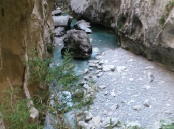
• Difficile mais belle randonnée qui mêle la contemplation d’un paysage splendide au plaisir de passages un peu physiqu...
![Percorso Marcia Aiguines - Sentier imbut - Photo](https://media.geolcdn.com/t/350/260/ext.jpg?maxdim=2&url=https%3A%2F%2Fstatic1.geolcdn.com%2Fsiteimages%2Fupload%2Ffiles%2F1553511878bg_sport_marche.png)
![Marcia Marcia](https://static1.geolcdn.com/sitytour/trail-icons/101.png)
Km
Marcia
![](/images/other/stat-length.png)
![](https://static1.geolcdn.com/siteimages/upload/files/1508320355ic_sort_den_pos_24dp.png)
![](https://static1.geolcdn.com/siteimages/upload/files/1508320355ic_sort_den_neg_24dp.png)
![](https://static1.geolcdn.com/siteimages/upload/files/16400158638029165_repeat_loop_refresh_sync_direction_icon.png)
20 percorsi visualizzati su 92
Applicazione GPS da escursionismo GRATUITA