![](/images/other/stat-length.png)
Landkreis Weimarer Land, Turingia : I migliori sentieri, percorsi e passeggiate
Landkreis Weimarer Land: Scopri i migliori percorsi: 27 percorsi a piedi. Tutti questi percorsi, itinerari e attività outdoor sono disponibili nelle nostre app SityTrail per smartphone e tablet.
I percorsi migliori (0})
![Percorso A piedi Kranichfeld - Kranich-Rundwanderweg 1 - Photo](https://media.geolcdn.com/t/350/260/74097348-87d2-42b2-9218-277a755d0837.jpeg&format=jpg&maxdim=2)
![A piedi A piedi](https://static1.geolcdn.com/sitytour/trail-icons/100.png)
Km
A piedi
![](/images/other/stat-length.png)
![](https://static1.geolcdn.com/siteimages/upload/files/1508320355ic_sort_den_pos_24dp.png)
![](https://static1.geolcdn.com/siteimages/upload/files/1508320355ic_sort_den_neg_24dp.png)
![](https://static1.geolcdn.com/siteimages/upload/files/16400158638029165_repeat_loop_refresh_sync_direction_icon.png)
• Trail created by Kranichfeld. Symbol: Weiße 1 auf schwarzem Hintergrund, drüber ein schwarzer Kranich auf weißem Gru...
![Percorso A piedi Kranichfeld - Kranich-Rundwanderweg 2 - Photo](https://media.geolcdn.com/t/350/260/fcb27b38-9c0c-43d1-96b9-a5d3e499e0c6.jpeg&format=jpg&maxdim=2)
![A piedi A piedi](https://static1.geolcdn.com/sitytour/trail-icons/100.png)
Km
A piedi
![](/images/other/stat-length.png)
![](https://static1.geolcdn.com/siteimages/upload/files/1508320355ic_sort_den_pos_24dp.png)
![](https://static1.geolcdn.com/siteimages/upload/files/1508320355ic_sort_den_neg_24dp.png)
![](https://static1.geolcdn.com/siteimages/upload/files/16400158638029165_repeat_loop_refresh_sync_direction_icon.png)
• Trail created by Kranichfeld. Symbol: Schwarze 2 auf gelbgrünem Hintergrund, drüber ein schwarzer Kranich auf weißem...
![Percorso A piedi Kranichfeld - Kranich-Rundwanderweg 5 - Photo](https://media.geolcdn.com/t/350/260/74097348-87d2-42b2-9218-277a755d0837.jpeg&format=jpg&maxdim=2)
![A piedi A piedi](https://static1.geolcdn.com/sitytour/trail-icons/100.png)
Km
A piedi
![](/images/other/stat-length.png)
![](https://static1.geolcdn.com/siteimages/upload/files/1508320355ic_sort_den_pos_24dp.png)
![](https://static1.geolcdn.com/siteimages/upload/files/1508320355ic_sort_den_neg_24dp.png)
![](https://static1.geolcdn.com/siteimages/upload/files/16400158638029165_repeat_loop_refresh_sync_direction_icon.png)
• Trail created by Kranichfeld. Symbol: Weiße 5 auf dunkelgrünem Hintergrund, drüber ein schwarzer Kranich auf weißem ...
![Percorso A piedi Kranichfeld - Kranich-Rundwanderweg 4 - Photo](https://media.geolcdn.com/t/350/260/107b3b36-5566-4eb2-a5f7-0596929cc96a.jpeg&format=jpg&maxdim=2)
![A piedi A piedi](https://static1.geolcdn.com/sitytour/trail-icons/100.png)
Km
A piedi
![](/images/other/stat-length.png)
![](https://static1.geolcdn.com/siteimages/upload/files/1508320355ic_sort_den_pos_24dp.png)
![](https://static1.geolcdn.com/siteimages/upload/files/1508320355ic_sort_den_neg_24dp.png)
![](https://static1.geolcdn.com/siteimages/upload/files/16400158638029165_repeat_loop_refresh_sync_direction_icon.png)
• Trail created by Kranichfeld. Symbol: Schwarze 4 auf rosa Hintergrund, drüber ein schwarzer Kranich auf weißem Grund.
![Percorso A piedi Bad Berka - Ludwig-Geist-Weg - Photo](https://media.geolcdn.com/t/350/260/0e45825d-8363-42f1-8ba7-0b70861684b0.jpeg&format=jpg&maxdim=2)
![A piedi A piedi](https://static1.geolcdn.com/sitytour/trail-icons/100.png)
Km
A piedi
![](/images/other/stat-length.png)
![](https://static1.geolcdn.com/siteimages/upload/files/1508320355ic_sort_den_pos_24dp.png)
![](https://static1.geolcdn.com/siteimages/upload/files/1508320355ic_sort_den_neg_24dp.png)
![](https://static1.geolcdn.com/siteimages/upload/files/16400158638029165_repeat_loop_refresh_sync_direction_icon.png)
• Trail created by Bad Berka. Symbol: schwarze 3 auf mittig senkrecht geteiltem, links blauen, rechts gelben Kreis
![Percorso A piedi Bad Berka - Heinrich-Schütz-Weg - Photo](https://media.geolcdn.com/t/350/260/0e45825d-8363-42f1-8ba7-0b70861684b0.jpeg&format=jpg&maxdim=2)
![A piedi A piedi](https://static1.geolcdn.com/sitytour/trail-icons/100.png)
Km
A piedi
![](/images/other/stat-length.png)
![](https://static1.geolcdn.com/siteimages/upload/files/1508320355ic_sort_den_pos_24dp.png)
![](https://static1.geolcdn.com/siteimages/upload/files/1508320355ic_sort_den_neg_24dp.png)
![](https://static1.geolcdn.com/siteimages/upload/files/16400158638029165_repeat_loop_refresh_sync_direction_icon.png)
• Trail created by Bad Berka. Symbol: schwarze 1 auf mittig senkrecht geteiltem, links baluen, rechts gelben Kreis
![Percorso A piedi Bad Berka - Justizrat-Reinhard-Weg - Photo](https://media.geolcdn.com/t/350/260/0e45825d-8363-42f1-8ba7-0b70861684b0.jpeg&format=jpg&maxdim=2)
![A piedi A piedi](https://static1.geolcdn.com/sitytour/trail-icons/100.png)
Km
A piedi
![](/images/other/stat-length.png)
![](https://static1.geolcdn.com/siteimages/upload/files/1508320355ic_sort_den_pos_24dp.png)
![](https://static1.geolcdn.com/siteimages/upload/files/1508320355ic_sort_den_neg_24dp.png)
![](https://static1.geolcdn.com/siteimages/upload/files/16400158638029165_repeat_loop_refresh_sync_direction_icon.png)
• Trail created by Bad Berka. Symbol: schwarze 2 auf mittig senkrecht geteiltem, links blauen, rechts gelben Kreis
![Percorso A piedi Bad Sulza - Weinwanderweg Bad Sulza - Photo](https://media.geolcdn.com/t/350/260/546476e3-25ce-483e-b2e9-a05d647513d4.jpeg&format=jpg&maxdim=2)
![A piedi A piedi](https://static1.geolcdn.com/sitytour/trail-icons/100.png)
Km
A piedi
![](/images/other/stat-length.png)
![](https://static1.geolcdn.com/siteimages/upload/files/1508320355ic_sort_den_pos_24dp.png)
![](https://static1.geolcdn.com/siteimages/upload/files/1508320355ic_sort_den_neg_24dp.png)
![](https://static1.geolcdn.com/siteimages/upload/files/16400158638029165_repeat_loop_refresh_sync_direction_icon.png)
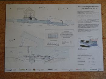
• Trail created by Touristinformation Bad Sulza. created by Johanna Müller
![Percorso A piedi Großheringen - Rundweg Kaatschen-Tultewitz - Photo](https://media.geolcdn.com/t/350/260/0da118d8-23e7-4f66-86b2-2f57f098cdb1.jpeg&format=jpg&maxdim=2)
![A piedi A piedi](https://static1.geolcdn.com/sitytour/trail-icons/100.png)
Km
A piedi
![](/images/other/stat-length.png)
![](https://static1.geolcdn.com/siteimages/upload/files/1508320355ic_sort_den_pos_24dp.png)
![](https://static1.geolcdn.com/siteimages/upload/files/1508320355ic_sort_den_neg_24dp.png)
![](https://static1.geolcdn.com/siteimages/upload/files/16400158638029165_repeat_loop_refresh_sync_direction_icon.png)
• unmarkiert
![Percorso A piedi Bad Berka - Ludwig-Häfner-Weg - Photo](https://media.geolcdn.com/t/350/260/24bfff84-3606-4d68-98bc-baa67bebd698.jpeg&format=jpg&maxdim=2)
![A piedi A piedi](https://static1.geolcdn.com/sitytour/trail-icons/100.png)
Km
A piedi
![](/images/other/stat-length.png)
![](https://static1.geolcdn.com/siteimages/upload/files/1508320355ic_sort_den_pos_24dp.png)
![](https://static1.geolcdn.com/siteimages/upload/files/1508320355ic_sort_den_neg_24dp.png)
![](https://static1.geolcdn.com/siteimages/upload/files/16400158638029165_repeat_loop_refresh_sync_direction_icon.png)
• Trail created by Bad Berka. Symbol: schwarze 7 auf mittig senkrecht geteiltem, links blauen, rechts gelben Kreis
![Percorso A piedi Bad Berka - Hexenberg-Rundweg - Photo](https://media.geolcdn.com/t/350/260/0e45825d-8363-42f1-8ba7-0b70861684b0.jpeg&format=jpg&maxdim=2)
![A piedi A piedi](https://static1.geolcdn.com/sitytour/trail-icons/100.png)
Km
A piedi
![](/images/other/stat-length.png)
![](https://static1.geolcdn.com/siteimages/upload/files/1508320355ic_sort_den_pos_24dp.png)
![](https://static1.geolcdn.com/siteimages/upload/files/1508320355ic_sort_den_neg_24dp.png)
![](https://static1.geolcdn.com/siteimages/upload/files/16400158638029165_repeat_loop_refresh_sync_direction_icon.png)
• Symbol: schwarze 6 auf mittig senkrecht geteiltem, links blauen, rechts gelben Kreis
![Percorso A piedi Bad Berka - grüner Balken Tannroda - Photo](https://media.geolcdn.com/t/350/260/7a56250f-64f6-4c3f-8ea5-6744e8b33f1c.jpeg&format=jpg&maxdim=2)
![A piedi A piedi](https://static1.geolcdn.com/sitytour/trail-icons/100.png)
Km
A piedi
![](/images/other/stat-length.png)
![](https://static1.geolcdn.com/siteimages/upload/files/1508320355ic_sort_den_pos_24dp.png)
![](https://static1.geolcdn.com/siteimages/upload/files/1508320355ic_sort_den_neg_24dp.png)
![](https://static1.geolcdn.com/siteimages/upload/files/16400158638029165_repeat_loop_refresh_sync_direction_icon.png)
• Wanderweg Grüner Balken Raum Tannroda
![Percorso A piedi Ilmtal-Weinstraße - Wanderweg - Photo](https://media.geolcdn.com/t/350/260/e1d9f7ac-1a19-41c7-8621-905720349f66.jpeg&format=jpg&maxdim=2)
![A piedi A piedi](https://static1.geolcdn.com/sitytour/trail-icons/100.png)
Km
A piedi
![](/images/other/stat-length.png)
![](https://static1.geolcdn.com/siteimages/upload/files/1508320355ic_sort_den_pos_24dp.png)
![](https://static1.geolcdn.com/siteimages/upload/files/1508320355ic_sort_den_neg_24dp.png)
![](https://static1.geolcdn.com/siteimages/upload/files/16400158638029165_repeat_loop_refresh_sync_direction_icon.png)
• Symbol: Grüner Strich auf weißem Grund
![Percorso A piedi Kranichfeld - lokales Wegenetz Gelber Balken - Photo](https://media.geolcdn.com/t/350/260/0e45825d-8363-42f1-8ba7-0b70861684b0.jpeg&format=jpg&maxdim=2)
![A piedi A piedi](https://static1.geolcdn.com/sitytour/trail-icons/100.png)
Km
A piedi
![](/images/other/stat-length.png)
![](https://static1.geolcdn.com/siteimages/upload/files/1508320355ic_sort_den_pos_24dp.png)
![](https://static1.geolcdn.com/siteimages/upload/files/1508320355ic_sort_den_neg_24dp.png)
![](https://static1.geolcdn.com/siteimages/upload/files/16400158638029165_repeat_loop_refresh_sync_direction_icon.png)
• Symbol: Gelber Querbalken auf weißem Grund
![Percorso A piedi Klettbach - lokales Wegenetz Grüner Balken - Photo](https://media.geolcdn.com/t/350/260/24bfff84-3606-4d68-98bc-baa67bebd698.jpeg&format=jpg&maxdim=2)
![A piedi A piedi](https://static1.geolcdn.com/sitytour/trail-icons/100.png)
Km
A piedi
![](/images/other/stat-length.png)
![](https://static1.geolcdn.com/siteimages/upload/files/1508320355ic_sort_den_pos_24dp.png)
![](https://static1.geolcdn.com/siteimages/upload/files/1508320355ic_sort_den_neg_24dp.png)
![](https://static1.geolcdn.com/siteimages/upload/files/16400158638029165_repeat_loop_refresh_sync_direction_icon.png)
• Symbol: Grüner Querbalken auf weißem Grund
![Percorso A piedi Bad Sulza - Im Brühlgrund - Photo](https://media.geolcdn.com/t/350/260/8819969a-a5b6-4421-a096-ec5464803ff6.jpeg&format=jpg&maxdim=2)
![A piedi A piedi](https://static1.geolcdn.com/sitytour/trail-icons/100.png)
Km
A piedi
![](/images/other/stat-length.png)
![](https://static1.geolcdn.com/siteimages/upload/files/1508320355ic_sort_den_pos_24dp.png)
![](https://static1.geolcdn.com/siteimages/upload/files/1508320355ic_sort_den_neg_24dp.png)
![](https://static1.geolcdn.com/siteimages/upload/files/16400158638029165_repeat_loop_refresh_sync_direction_icon.png)
![Percorso A piedi Bad Sulza - Schlachtfelder Bad Sulza - Photo](https://media.geolcdn.com/t/350/260/cbfb1c52-a17d-4f84-b71b-5f785beb0f9d.jpeg&format=jpg&maxdim=2)
![A piedi A piedi](https://static1.geolcdn.com/sitytour/trail-icons/100.png)
Km
A piedi
![](/images/other/stat-length.png)
![](https://static1.geolcdn.com/siteimages/upload/files/1508320355ic_sort_den_pos_24dp.png)
![](https://static1.geolcdn.com/siteimages/upload/files/1508320355ic_sort_den_neg_24dp.png)
![](https://static1.geolcdn.com/siteimages/upload/files/16400158638029165_repeat_loop_refresh_sync_direction_icon.png)
![Percorso A piedi Bad Sulza - Utenbach Wanderweg - Photo](https://media.geolcdn.com/t/350/260/7100866e-bc39-4da0-80b2-cb6458a9b1e0.jpeg&format=jpg&maxdim=2)
![A piedi A piedi](https://static1.geolcdn.com/sitytour/trail-icons/100.png)
Km
A piedi
![](/images/other/stat-length.png)
![](https://static1.geolcdn.com/siteimages/upload/files/1508320355ic_sort_den_pos_24dp.png)
![](https://static1.geolcdn.com/siteimages/upload/files/1508320355ic_sort_den_neg_24dp.png)
![](https://static1.geolcdn.com/siteimages/upload/files/16400158638029165_repeat_loop_refresh_sync_direction_icon.png)
![Percorso A piedi Bad Sulza - Himmelreich Rundweg Bad Sulza - Photo](https://media.geolcdn.com/t/350/260/ea54403f-f3af-4d92-a3f2-340d70a02da5.jpeg&format=jpg&maxdim=2)
![A piedi A piedi](https://static1.geolcdn.com/sitytour/trail-icons/100.png)
Km
A piedi
![](/images/other/stat-length.png)
![](https://static1.geolcdn.com/siteimages/upload/files/1508320355ic_sort_den_pos_24dp.png)
![](https://static1.geolcdn.com/siteimages/upload/files/1508320355ic_sort_den_neg_24dp.png)
![](https://static1.geolcdn.com/siteimages/upload/files/16400158638029165_repeat_loop_refresh_sync_direction_icon.png)
![Percorso A piedi Bad Sulza - Panorama Rundweg - Photo](https://media.geolcdn.com/t/350/260/d890ab57-cf55-4034-9612-7555cf97d79f.jpeg&format=jpg&maxdim=2)
![A piedi A piedi](https://static1.geolcdn.com/sitytour/trail-icons/100.png)
Km
A piedi
![](/images/other/stat-length.png)
![](https://static1.geolcdn.com/siteimages/upload/files/1508320355ic_sort_den_pos_24dp.png)
![](https://static1.geolcdn.com/siteimages/upload/files/1508320355ic_sort_den_neg_24dp.png)
![](https://static1.geolcdn.com/siteimages/upload/files/16400158638029165_repeat_loop_refresh_sync_direction_icon.png)
20 percorsi visualizzati su 27
Applicazione GPS da escursionismo GRATUITA