


3,2 km | 4,3 km-effort
Landkreis Breisgau-Hochschwarzwald: Scopri i migliori percorsi: 114 percorsi a piedi e 22 percorsi in bicicletta o MTB. Tutti questi percorsi, itinerari e attività outdoor sono disponibili nelle nostre app SityTrail per smartphone e tablet.
A piedi


• Trail created by Schwarzwaldverein. Habstmoos - Bannwald Zweribach Symbol: Gelbe Raute auf weißem Grund
A piedi
• Trail created by Schwarzwaldverein e.V.. Symbol: Blaue Raute auf weißem Grund
A piedi
• Trail created by Naturpark Südschwarzwald.
A piedi
• Trail created by Schwarzwaldverein e.V..
A piedi
• mehrer Symbole im Wegverlauf Symbol: gelbe Raute liegend auf weissem Grund
A piedi
• Südhangwanderung auf kleinen Bergpfaden hinauf zum Aussichtsplateau Breitacker, Wildnispfad - nicht durchgängig besch...
A piedi
• Trail created by Schwarzwaldverein. Symbol: Gelbe Raute auf weißem Grund
A piedi
• Trail created by Schwarzwaldverein. Symbol: Gelbe Raute auf weißem Grund
A piedi
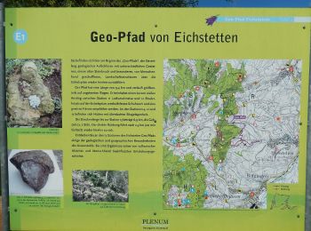
• Trail created by PLENUM Naturgarten Kaiserstuhl. Symbol: Gelbe Raute auf weißem Grund
A piedi
• Trail created by Schwarzwaldverein.
A piedi
• Symbol: Gelbe Raute auf weißem Grund
A piedi
• Trail created by PLENUM Naturgarten Kaiserstuhl. Symbol: Gelbe Raute auf weißem Grund
A piedi
• Trail created by Schwarzwaldverein. Symbol: Blaue Raute auf weißem Grund
A piedi
• Trail created by Schwarzwaldverein e.V.. Symbol: Blaue Raute auf weißem Grund
A piedi
• Trail created by HTG.
A piedi
• Trail created by Schwarzwaldverein. Symbol: Blaue Raute auf weißem Grund
A piedi
• Ehemalige Krummensäge - Kohlhütte - fixme Symbol: blauer Diamant (waagrecht) mit senkrechtem Strich (weiss)
A piedi
• Muchenländer Brücke - Schubenwald Symbol: gelber Diamant (waagrecht)
A piedi
• Trail created by Schwarzwaldverein. Symbol: Blaue Route auf weißem Grund
A piedi
• Trail created by Schwarzwaldverein. Symbol: Blaue Route auf weißem Grund
20 percorsi visualizzati su 147
Applicazione GPS da escursionismo GRATUITA
 SityTrail
IGN / Istituti geografici
SityTrail World
Il mondo è tuo