![](/images/other/stat-length.png)
- Percorsi
- Outdoor
- Germany
- Baviera
- Landkreis Traunstein
- Reit im Winkl
Reit im Winkl, Landkreis Traunstein : I migliori sentieri, percorsi e passeggiate
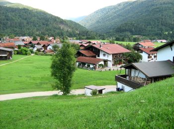
Reit im Winkl: Scopri i migliori percorsi: 6 percorsi a piedi. Tutti questi percorsi, itinerari e attività outdoor sono disponibili nelle nostre app SityTrail per smartphone e tablet.
I percorsi migliori (0})
![Percorso A piedi Reit im Winkl - Wanderweg 14 - Reit im Winkl - Photo](https://media.geolcdn.com/t/350/260/1c890e26-e4a9-4d0e-b97b-8f5a1969d3b8.jpeg&format=jpg&maxdim=2)
![A piedi A piedi](https://static1.geolcdn.com/sitytour/trail-icons/100.png)
Km
A piedi
![](/images/other/stat-length.png)
![](https://static1.geolcdn.com/siteimages/upload/files/1508320355ic_sort_den_pos_24dp.png)
![](https://static1.geolcdn.com/siteimages/upload/files/1508320355ic_sort_den_neg_24dp.png)
![](https://static1.geolcdn.com/siteimages/upload/files/16400158638029165_repeat_loop_refresh_sync_direction_icon.png)
• Symbol: Gelbe Wegweisschilder mit Text und Zahl
![Percorso A piedi Reit im Winkl - Winklmoosalm - Dürrnbachhorn - Photo](https://media.geolcdn.com/t/350/260/b4e550a9-f667-44fe-b589-db52df25738b.jpeg&format=jpg&maxdim=2)
![A piedi A piedi](https://static1.geolcdn.com/sitytour/trail-icons/100.png)
Km
A piedi
![](/images/other/stat-length.png)
![](https://static1.geolcdn.com/siteimages/upload/files/1508320355ic_sort_den_pos_24dp.png)
![](https://static1.geolcdn.com/siteimages/upload/files/1508320355ic_sort_den_neg_24dp.png)
![](https://static1.geolcdn.com/siteimages/upload/files/16400158638029165_repeat_loop_refresh_sync_direction_icon.png)
• Symbol: schwarze Schrift 12 auf orangenem Grund
![Percorso A piedi Reit im Winkl - Wanderweg 131 - Reit im Winkl - Photo](https://media.geolcdn.com/t/350/260/1c890e26-e4a9-4d0e-b97b-8f5a1969d3b8.jpeg&format=jpg&maxdim=2)
![A piedi A piedi](https://static1.geolcdn.com/sitytour/trail-icons/100.png)
Km
A piedi
![](/images/other/stat-length.png)
![](https://static1.geolcdn.com/siteimages/upload/files/1508320355ic_sort_den_pos_24dp.png)
![](https://static1.geolcdn.com/siteimages/upload/files/1508320355ic_sort_den_neg_24dp.png)
![](https://static1.geolcdn.com/siteimages/upload/files/16400158638029165_repeat_loop_refresh_sync_direction_icon.png)
• Symbol: Gelbe Wegweisschilder mit Text und Zahl
![Percorso A piedi Reit im Winkl - Wanderweg 9 - Reit im Winkl - Photo](https://media.geolcdn.com/t/350/260/ad67f29d-8ead-4b07-8a55-a72108354d1c.jpeg&format=jpg&maxdim=2)
![A piedi A piedi](https://static1.geolcdn.com/sitytour/trail-icons/100.png)
Km
A piedi
![](/images/other/stat-length.png)
![](https://static1.geolcdn.com/siteimages/upload/files/1508320355ic_sort_den_pos_24dp.png)
![](https://static1.geolcdn.com/siteimages/upload/files/1508320355ic_sort_den_neg_24dp.png)
![](https://static1.geolcdn.com/siteimages/upload/files/16400158638029165_repeat_loop_refresh_sync_direction_icon.png)
• Symbol: Gelbe Wegweisschilder mit Text und Zahl
![Percorso A piedi Reit im Winkl - Wanderweg 18 - Reit im Winkl - Photo](https://media.geolcdn.com/t/350/260/72efd524-69ac-4af5-bb69-8cbdde1760e7.jpeg&format=jpg&maxdim=2)
![A piedi A piedi](https://static1.geolcdn.com/sitytour/trail-icons/100.png)
Km
A piedi
![](/images/other/stat-length.png)
![](https://static1.geolcdn.com/siteimages/upload/files/1508320355ic_sort_den_pos_24dp.png)
![](https://static1.geolcdn.com/siteimages/upload/files/1508320355ic_sort_den_neg_24dp.png)
![](https://static1.geolcdn.com/siteimages/upload/files/16400158638029165_repeat_loop_refresh_sync_direction_icon.png)
• Symbol: Gelbe Wegweisschilder mit Text und Zahl
![Percorso A piedi Reit im Winkl - Wanderweg 6 - Reit im Winkl - Photo](https://media.geolcdn.com/t/350/260/72efd524-69ac-4af5-bb69-8cbdde1760e7.jpeg&format=jpg&maxdim=2)
![A piedi A piedi](https://static1.geolcdn.com/sitytour/trail-icons/100.png)
Km
A piedi
![](/images/other/stat-length.png)
![](https://static1.geolcdn.com/siteimages/upload/files/1508320355ic_sort_den_pos_24dp.png)
![](https://static1.geolcdn.com/siteimages/upload/files/1508320355ic_sort_den_neg_24dp.png)
![](https://static1.geolcdn.com/siteimages/upload/files/16400158638029165_repeat_loop_refresh_sync_direction_icon.png)
• Symbol: Gelbe Wegweisschilder mit Text und Zahl
6 percorsi visualizzati su 6
Applicazione GPS da escursionismo GRATUITA