![](/images/other/stat-length.png)
- Percorsi
- Outdoor
- Czech Republic
- Střední Morava
Střední Morava, Czech Republic : I migliori sentieri, percorsi e passeggiate
Střední Morava: Scopri i migliori percorsi: 141 percorsi a piedi. Tutti questi percorsi, itinerari e attività outdoor sono disponibili nelle nostre app SityTrail per smartphone e tablet.
I percorsi migliori (0})
![Percorso A piedi Olomouc - žlutý místní okruh Svatý kopeček - Photo](https://media.geolcdn.com/t/350/260/82dc9e37-b126-4d08-b297-3d283d21421e.jpeg&format=jpg&maxdim=2)
![A piedi A piedi](https://static1.geolcdn.com/sitytour/trail-icons/100.png)
Km
A piedi
![](/images/other/stat-length.png)
![](https://static1.geolcdn.com/siteimages/upload/files/1508320355ic_sort_den_pos_24dp.png)
![](https://static1.geolcdn.com/siteimages/upload/files/1508320355ic_sort_den_neg_24dp.png)
![](https://static1.geolcdn.com/siteimages/upload/files/16400158638029165_repeat_loop_refresh_sync_direction_icon.png)
• Percorso creato da cz:KČT.
![Percorso A piedi Olomouc - zelený místní okruh Svatý kopeček - Photo](https://media.geolcdn.com/t/350/260/7fcda208-1c27-426e-93f3-b39b2dcac466.jpeg&format=jpg&maxdim=2)
![A piedi A piedi](https://static1.geolcdn.com/sitytour/trail-icons/100.png)
Km
A piedi
![](/images/other/stat-length.png)
![](https://static1.geolcdn.com/siteimages/upload/files/1508320355ic_sort_den_pos_24dp.png)
![](https://static1.geolcdn.com/siteimages/upload/files/1508320355ic_sort_den_neg_24dp.png)
![](https://static1.geolcdn.com/siteimages/upload/files/16400158638029165_repeat_loop_refresh_sync_direction_icon.png)
• Percorso creato da cz:KČT.
![Percorso A piedi Olomouc - místní okruh Mariánské údolí - Velká Bystřice - Svatý kopeček - Photo](https://media.geolcdn.com/t/350/260/101996d1-c8dc-4469-bfaf-b8486d64d3a3.jpeg&format=jpg&maxdim=2)
![A piedi A piedi](https://static1.geolcdn.com/sitytour/trail-icons/100.png)
Km
A piedi
![](/images/other/stat-length.png)
![](https://static1.geolcdn.com/siteimages/upload/files/1508320355ic_sort_den_pos_24dp.png)
![](https://static1.geolcdn.com/siteimages/upload/files/1508320355ic_sort_den_neg_24dp.png)
![](https://static1.geolcdn.com/siteimages/upload/files/16400158638029165_repeat_loop_refresh_sync_direction_icon.png)
• Percorso creato da cz:KČT.
![Percorso A piedi Senice na Hané - NS Elišky z Kunštátu - Photo](https://media.geolcdn.com/t/350/260/4d1449a7-b2b6-4cb4-aaeb-ec2a9aea6a88.jpeg&format=jpg&maxdim=2)
![A piedi A piedi](https://static1.geolcdn.com/sitytour/trail-icons/100.png)
Km
A piedi
![](/images/other/stat-length.png)
![](https://static1.geolcdn.com/siteimages/upload/files/1508320355ic_sort_den_pos_24dp.png)
![](https://static1.geolcdn.com/siteimages/upload/files/1508320355ic_sort_den_neg_24dp.png)
![](https://static1.geolcdn.com/siteimages/upload/files/16400158638029165_repeat_loop_refresh_sync_direction_icon.png)
• Percorso creato da cz:KČT.
![Percorso A piedi Popovice - CZ-Turistický okruh Bukovina - Photo](https://media.geolcdn.com/t/350/260/d55da369-d29d-435b-ae09-8b1115b167ec.jpeg&format=jpg&maxdim=2)
![A piedi A piedi](https://static1.geolcdn.com/sitytour/trail-icons/100.png)
Km
A piedi
![](/images/other/stat-length.png)
![](https://static1.geolcdn.com/siteimages/upload/files/1508320355ic_sort_den_pos_24dp.png)
![](https://static1.geolcdn.com/siteimages/upload/files/1508320355ic_sort_den_neg_24dp.png)
![](https://static1.geolcdn.com/siteimages/upload/files/16400158638029165_repeat_loop_refresh_sync_direction_icon.png)
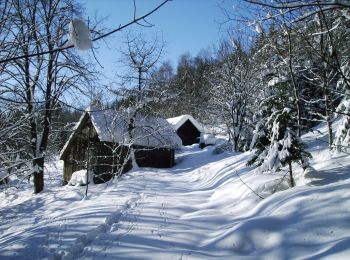
• Percorso creato da cz:KČT. Turistický okruh Bukovina
![Percorso A piedi Ludkovice - [Z] Lukáščena - Provodov - Photo](https://media.geolcdn.com/t/350/260/e1671f19-b9cb-4aa1-a32b-4cbea8d7ce75.jpeg&format=jpg&maxdim=2)
![A piedi A piedi](https://static1.geolcdn.com/sitytour/trail-icons/100.png)
Km
A piedi
![](/images/other/stat-length.png)
![](https://static1.geolcdn.com/siteimages/upload/files/1508320355ic_sort_den_pos_24dp.png)
![](https://static1.geolcdn.com/siteimages/upload/files/1508320355ic_sort_den_neg_24dp.png)
![](https://static1.geolcdn.com/siteimages/upload/files/16400158638029165_repeat_loop_refresh_sync_direction_icon.png)
• Percorso creato da cz:KČT.
![Percorso A piedi Velké Karlovice - Okruh Galik - Horal - Photo](https://media.geolcdn.com/t/350/260/55a9f7db-9dd0-4d44-884a-90affea5c38d.jpeg&format=jpg&maxdim=2)
![A piedi A piedi](https://static1.geolcdn.com/sitytour/trail-icons/100.png)
Km
A piedi
![](/images/other/stat-length.png)
![](https://static1.geolcdn.com/siteimages/upload/files/1508320355ic_sort_den_pos_24dp.png)
![](https://static1.geolcdn.com/siteimages/upload/files/1508320355ic_sort_den_neg_24dp.png)
![](https://static1.geolcdn.com/siteimages/upload/files/16400158638029165_repeat_loop_refresh_sync_direction_icon.png)
• Percorso creato da cz:KČT.
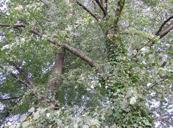
![Percorso A piedi Rapotín - [Ž] - Photo](https://media.geolcdn.com/t/350/260/ca426870-e86c-4a96-bde0-2f91190915ef.jpeg&format=jpg&maxdim=2)
![A piedi A piedi](https://static1.geolcdn.com/sitytour/trail-icons/100.png)
Km
A piedi
![](/images/other/stat-length.png)
![](https://static1.geolcdn.com/siteimages/upload/files/1508320355ic_sort_den_pos_24dp.png)
![](https://static1.geolcdn.com/siteimages/upload/files/1508320355ic_sort_den_neg_24dp.png)
![](https://static1.geolcdn.com/siteimages/upload/files/16400158638029165_repeat_loop_refresh_sync_direction_icon.png)
• Percorso creato da cz:KČT.
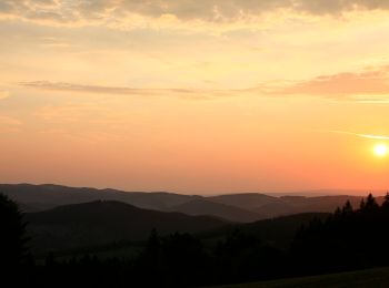
![Percorso A piedi Rapotín - [M] - Photo](https://media.geolcdn.com/t/350/260/2389b978-f881-4d49-8011-c5e6270880f1.jpeg&format=jpg&maxdim=2)
![A piedi A piedi](https://static1.geolcdn.com/sitytour/trail-icons/100.png)
Km
A piedi
![](/images/other/stat-length.png)
![](https://static1.geolcdn.com/siteimages/upload/files/1508320355ic_sort_den_pos_24dp.png)
![](https://static1.geolcdn.com/siteimages/upload/files/1508320355ic_sort_den_neg_24dp.png)
![](https://static1.geolcdn.com/siteimages/upload/files/16400158638029165_repeat_loop_refresh_sync_direction_icon.png)
• Percorso creato da cz:KČT.
![Percorso A piedi Konice - [Z] Runářov - Konice - Photo](https://media.geolcdn.com/t/350/260/90af7c62-097b-4fe0-b74f-f80499e5b5f8.jpeg&format=jpg&maxdim=2)
![A piedi A piedi](https://static1.geolcdn.com/sitytour/trail-icons/100.png)
Km
A piedi
![](/images/other/stat-length.png)
![](https://static1.geolcdn.com/siteimages/upload/files/1508320355ic_sort_den_pos_24dp.png)
![](https://static1.geolcdn.com/siteimages/upload/files/1508320355ic_sort_den_neg_24dp.png)
![](https://static1.geolcdn.com/siteimages/upload/files/16400158638029165_repeat_loop_refresh_sync_direction_icon.png)
• Percorso creato da cz:KČT.
![Percorso A piedi Zděchov - NS Zděchov - Photo](https://media.geolcdn.com/t/350/260/834c9a92-81c9-46c8-87cf-bf97a4d4f5b7.jpeg&format=jpg&maxdim=2)
![A piedi A piedi](https://static1.geolcdn.com/sitytour/trail-icons/100.png)
Km
A piedi
![](/images/other/stat-length.png)
![](https://static1.geolcdn.com/siteimages/upload/files/1508320355ic_sort_den_pos_24dp.png)
![](https://static1.geolcdn.com/siteimages/upload/files/1508320355ic_sort_den_neg_24dp.png)
![](https://static1.geolcdn.com/siteimages/upload/files/16400158638029165_repeat_loop_refresh_sync_direction_icon.png)
• NS
![Percorso A piedi Rapotín - naučná stezka Bukovka - Photo](https://media.geolcdn.com/t/350/260/ca426870-e86c-4a96-bde0-2f91190915ef.jpeg&format=jpg&maxdim=2)
![A piedi A piedi](https://static1.geolcdn.com/sitytour/trail-icons/100.png)
Km
A piedi
![](/images/other/stat-length.png)
![](https://static1.geolcdn.com/siteimages/upload/files/1508320355ic_sort_den_pos_24dp.png)
![](https://static1.geolcdn.com/siteimages/upload/files/1508320355ic_sort_den_neg_24dp.png)
![](https://static1.geolcdn.com/siteimages/upload/files/16400158638029165_repeat_loop_refresh_sync_direction_icon.png)
• Percorso creato da cz:KČT.
![Percorso A piedi Kobylá nad Vidnavkou - Naučná stezka nejen pro handicapované - Photo](https://media.geolcdn.com/t/350/260/ea13d288-17df-44b7-8a9e-0788db92a1de.jpeg&format=jpg&maxdim=2)
![A piedi A piedi](https://static1.geolcdn.com/sitytour/trail-icons/100.png)
Km
A piedi
![](/images/other/stat-length.png)
![](https://static1.geolcdn.com/siteimages/upload/files/1508320355ic_sort_den_pos_24dp.png)
![](https://static1.geolcdn.com/siteimages/upload/files/1508320355ic_sort_den_neg_24dp.png)
![](https://static1.geolcdn.com/siteimages/upload/files/16400158638029165_repeat_loop_refresh_sync_direction_icon.png)
• Percorso creato da cz:KČT.
![Percorso A piedi Chvalčov - Naučná stezka Chodník Masarykových - Photo](https://media.geolcdn.com/t/350/260/03db5ef3-b518-44ba-91e0-022ae3b0ed84.jpeg&format=jpg&maxdim=2)
![A piedi A piedi](https://static1.geolcdn.com/sitytour/trail-icons/100.png)
Km
A piedi
![](/images/other/stat-length.png)
![](https://static1.geolcdn.com/siteimages/upload/files/1508320355ic_sort_den_pos_24dp.png)
![](https://static1.geolcdn.com/siteimages/upload/files/1508320355ic_sort_den_neg_24dp.png)
![](https://static1.geolcdn.com/siteimages/upload/files/16400158638029165_repeat_loop_refresh_sync_direction_icon.png)
• Percorso creato da obec Chvalčov.
![Percorso A piedi Nový Hrozenkov - Velka- Studanky - Photo](https://media.geolcdn.com/t/350/260/f5f78048-1bf5-4521-b4f0-e61c3e953709.jpeg&format=jpg&maxdim=2)
![A piedi A piedi](https://static1.geolcdn.com/sitytour/trail-icons/100.png)
Km
A piedi
![](/images/other/stat-length.png)
![](https://static1.geolcdn.com/siteimages/upload/files/1508320355ic_sort_den_pos_24dp.png)
![](https://static1.geolcdn.com/siteimages/upload/files/1508320355ic_sort_den_neg_24dp.png)
![](https://static1.geolcdn.com/siteimages/upload/files/16400158638029165_repeat_loop_refresh_sync_direction_icon.png)
• Percorso creato da cz:KČT.
![Percorso A piedi Valašská Polanka - NS Vartovna - Photo](https://media.geolcdn.com/t/350/260/e054a369-61d5-4cdb-bc7a-0b1e53e974f6.jpeg&format=jpg&maxdim=2)
![A piedi A piedi](https://static1.geolcdn.com/sitytour/trail-icons/100.png)
Km
A piedi
![](/images/other/stat-length.png)
![](https://static1.geolcdn.com/siteimages/upload/files/1508320355ic_sort_den_pos_24dp.png)
![](https://static1.geolcdn.com/siteimages/upload/files/1508320355ic_sort_den_neg_24dp.png)
![](https://static1.geolcdn.com/siteimages/upload/files/16400158638029165_repeat_loop_refresh_sync_direction_icon.png)
• Percorso creato da cz:KČT.
![Percorso A piedi Lačnov - NS Varakovy paseky - Photo](https://media.geolcdn.com/t/350/260/5384b13d-0a01-44ad-b4b1-991d0110f8ae.jpeg&format=jpg&maxdim=2)
![A piedi A piedi](https://static1.geolcdn.com/sitytour/trail-icons/100.png)
Km
A piedi
![](/images/other/stat-length.png)
![](https://static1.geolcdn.com/siteimages/upload/files/1508320355ic_sort_den_pos_24dp.png)
![](https://static1.geolcdn.com/siteimages/upload/files/1508320355ic_sort_den_neg_24dp.png)
![](https://static1.geolcdn.com/siteimages/upload/files/16400158638029165_repeat_loop_refresh_sync_direction_icon.png)
• Percorso creato da cz:KČT.
![Percorso A piedi Francova Lhota - NS Pulčínská cesta - Photo](https://media.geolcdn.com/t/350/260/f8b0f0ba-7d80-46c9-8ae5-48edc92855f3.jpeg&format=jpg&maxdim=2)
![A piedi A piedi](https://static1.geolcdn.com/sitytour/trail-icons/100.png)
Km
A piedi
![](/images/other/stat-length.png)
![](https://static1.geolcdn.com/siteimages/upload/files/1508320355ic_sort_den_pos_24dp.png)
![](https://static1.geolcdn.com/siteimages/upload/files/1508320355ic_sort_den_neg_24dp.png)
![](https://static1.geolcdn.com/siteimages/upload/files/16400158638029165_repeat_loop_refresh_sync_direction_icon.png)
• Percorso creato da cz:KČT.
![Percorso A piedi Poličná - NS T.G. Masaryka - Photo](https://media.geolcdn.com/t/350/260/5a1be994-7043-478b-8e05-cbbf0ba96ef6.jpeg&format=jpg&maxdim=2)
![A piedi A piedi](https://static1.geolcdn.com/sitytour/trail-icons/100.png)
Km
A piedi
![](/images/other/stat-length.png)
![](https://static1.geolcdn.com/siteimages/upload/files/1508320355ic_sort_den_pos_24dp.png)
![](https://static1.geolcdn.com/siteimages/upload/files/1508320355ic_sort_den_neg_24dp.png)
![](https://static1.geolcdn.com/siteimages/upload/files/16400158638029165_repeat_loop_refresh_sync_direction_icon.png)
• Percorso creato da ČSOP Valašské Meziříčí.
![Percorso A piedi Růžďka - NS Kllenov - Photo](https://media.geolcdn.com/t/350/260/e7afc6f6-9a48-41b7-9ed8-5d69d9991048.jpeg&format=jpg&maxdim=2)
![A piedi A piedi](https://static1.geolcdn.com/sitytour/trail-icons/100.png)
Km
A piedi
![](/images/other/stat-length.png)
![](https://static1.geolcdn.com/siteimages/upload/files/1508320355ic_sort_den_pos_24dp.png)
![](https://static1.geolcdn.com/siteimages/upload/files/1508320355ic_sort_den_neg_24dp.png)
![](https://static1.geolcdn.com/siteimages/upload/files/16400158638029165_repeat_loop_refresh_sync_direction_icon.png)
• Percorso creato da cz:KČT.
20 percorsi visualizzati su 141
Applicazione GPS da escursionismo GRATUITA