![](/images/other/stat-length.png)
- Percorsi
- Outdoor
- Switzerland
- Zurigo
- Bezirk Winterthur
Bezirk Winterthur, Zurigo : I migliori sentieri, percorsi e passeggiate
Bezirk Winterthur: Scopri i migliori percorsi: 27 percorsi a piedi. Tutti questi percorsi, itinerari e attività outdoor sono disponibili nelle nostre app SityTrail per smartphone e tablet.
I percorsi migliori (0})
![Percorso A piedi Winterthur - Rundweg Winterthur - Etappe Leisental - Photo](https://media.geolcdn.com/t/350/260/b46f637d-974f-48a1-98b4-7a6fcf478692.jpeg&format=jpg&maxdim=2)
![A piedi A piedi](https://static1.geolcdn.com/sitytour/trail-icons/100.png)
Km
A piedi
![](/images/other/stat-length.png)
![](https://static1.geolcdn.com/siteimages/upload/files/1508320355ic_sort_den_pos_24dp.png)
![](https://static1.geolcdn.com/siteimages/upload/files/1508320355ic_sort_den_neg_24dp.png)
![](https://static1.geolcdn.com/siteimages/upload/files/16400158638029165_repeat_loop_refresh_sync_direction_icon.png)
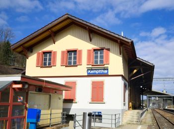
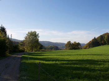
• Etappe Leisental: Sennhof Kemptthal Sito web: https://www.rundweg.winterthur.ch/index.php?ref=search&refid=334444...
![Percorso A piedi Winterthur - Brunibrugg - Kyburgerbrugg - Photo](https://media.geolcdn.com/t/350/260/9b0fa434-55c2-423a-913e-72b1327bfe19.jpeg&format=jpg&maxdim=2)
![A piedi A piedi](https://static1.geolcdn.com/sitytour/trail-icons/100.png)
Km
A piedi
![](/images/other/stat-length.png)
![](https://static1.geolcdn.com/siteimages/upload/files/1508320355ic_sort_den_pos_24dp.png)
![](https://static1.geolcdn.com/siteimages/upload/files/1508320355ic_sort_den_neg_24dp.png)
![](https://static1.geolcdn.com/siteimages/upload/files/16400158638029165_repeat_loop_refresh_sync_direction_icon.png)
• Trail created by Zürcher Wanderwege ZAW. Symbol: gelbe Raute
![Percorso A piedi Winterthur - Ritplatz - Chämleten - Photo](https://media.geolcdn.com/t/350/260/76f7eae9-adf9-478d-a972-b8ace6f07a39.jpeg&format=jpg&maxdim=2)
![A piedi A piedi](https://static1.geolcdn.com/sitytour/trail-icons/100.png)
Km
A piedi
![](/images/other/stat-length.png)
![](https://static1.geolcdn.com/siteimages/upload/files/1508320355ic_sort_den_pos_24dp.png)
![](https://static1.geolcdn.com/siteimages/upload/files/1508320355ic_sort_den_neg_24dp.png)
![](https://static1.geolcdn.com/siteimages/upload/files/16400158638029165_repeat_loop_refresh_sync_direction_icon.png)
• Trail created by Zürcher Wanderwege ZAW. Symbol: gelbe Raute
![Percorso A piedi Winterthur - Sennhof - Winterthur - Photo](https://media.geolcdn.com/t/350/260/6b98930b-4675-4823-904a-18a6989af0aa.jpeg&format=jpg&maxdim=2)
![A piedi A piedi](https://static1.geolcdn.com/sitytour/trail-icons/100.png)
Km
A piedi
![](/images/other/stat-length.png)
![](https://static1.geolcdn.com/siteimages/upload/files/1508320355ic_sort_den_pos_24dp.png)
![](https://static1.geolcdn.com/siteimages/upload/files/1508320355ic_sort_den_neg_24dp.png)
![](https://static1.geolcdn.com/siteimages/upload/files/16400158638029165_repeat_loop_refresh_sync_direction_icon.png)
• Trail created by Zürcher Wanderwege ZAW. Symbol: gelbe Raute
![Percorso A piedi Neftenbach - Tössegg-Klettgau-Weg - Photo](https://media.geolcdn.com/t/350/260/4d46e80c-f6de-449c-aa91-73ffe3091aa2.jpeg&format=jpg&maxdim=2)
![A piedi A piedi](https://static1.geolcdn.com/sitytour/trail-icons/100.png)
Km
A piedi
![](/images/other/stat-length.png)
![](https://static1.geolcdn.com/siteimages/upload/files/1508320355ic_sort_den_pos_24dp.png)
![](https://static1.geolcdn.com/siteimages/upload/files/1508320355ic_sort_den_neg_24dp.png)
![](https://static1.geolcdn.com/siteimages/upload/files/16400158638029165_repeat_loop_refresh_sync_direction_icon.png)
• Trail created by Wanderland Schweiz. Symbol: Weinrebe zusammen mit schwarzer Schrift Tössegg Klettgau Weg in grünem ...
![Percorso A piedi Pfungen - Pfungen - Stiegen - Photo](https://media.geolcdn.com/t/350/260/5e13f51a-5798-4564-9709-f178bcab977e.jpeg&format=jpg&maxdim=2)
![A piedi A piedi](https://static1.geolcdn.com/sitytour/trail-icons/100.png)
Km
A piedi
![](/images/other/stat-length.png)
![](https://static1.geolcdn.com/siteimages/upload/files/1508320355ic_sort_den_pos_24dp.png)
![](https://static1.geolcdn.com/siteimages/upload/files/1508320355ic_sort_den_neg_24dp.png)
![](https://static1.geolcdn.com/siteimages/upload/files/16400158638029165_repeat_loop_refresh_sync_direction_icon.png)
• Trail created by Zürcher Wanderwege ZAW. Symbol: gelbe Raute
![Percorso A piedi Brütten - Effretikon - Wülflingen - Photo](https://media.geolcdn.com/t/350/260/ffc97948-63ac-4c76-b9d4-b267680ed02f.jpeg&format=jpg&maxdim=2)
![A piedi A piedi](https://static1.geolcdn.com/sitytour/trail-icons/100.png)
Km
A piedi
![](/images/other/stat-length.png)
![](https://static1.geolcdn.com/siteimages/upload/files/1508320355ic_sort_den_pos_24dp.png)
![](https://static1.geolcdn.com/siteimages/upload/files/1508320355ic_sort_den_neg_24dp.png)
![](https://static1.geolcdn.com/siteimages/upload/files/16400158638029165_repeat_loop_refresh_sync_direction_icon.png)
• Trail created by Zürcher Wanderwege ZAW. Symbol: gelbe Raute
![Percorso A piedi Winterthur - Winterthur Töss - Pfungen - Photo](https://media.geolcdn.com/t/350/260/64d1243c-eecf-47bc-8037-a387c6e3e4be.jpeg&format=jpg&maxdim=2)
![A piedi A piedi](https://static1.geolcdn.com/sitytour/trail-icons/100.png)
Km
A piedi
![](/images/other/stat-length.png)
![](https://static1.geolcdn.com/siteimages/upload/files/1508320355ic_sort_den_pos_24dp.png)
![](https://static1.geolcdn.com/siteimages/upload/files/1508320355ic_sort_den_neg_24dp.png)
![](https://static1.geolcdn.com/siteimages/upload/files/16400158638029165_repeat_loop_refresh_sync_direction_icon.png)
• Trail created by Zürcher Wanderwege ZAW. Symbol: gelbe Raute
![Percorso A piedi Pfungen - Pfungen - Oberembrach - Photo](https://media.geolcdn.com/t/350/260/264f6337-3574-4ad2-a1a3-6195a173578f.jpeg&format=jpg&maxdim=2)
![A piedi A piedi](https://static1.geolcdn.com/sitytour/trail-icons/100.png)
Km
A piedi
![](/images/other/stat-length.png)
![](https://static1.geolcdn.com/siteimages/upload/files/1508320355ic_sort_den_pos_24dp.png)
![](https://static1.geolcdn.com/siteimages/upload/files/1508320355ic_sort_den_neg_24dp.png)
![](https://static1.geolcdn.com/siteimages/upload/files/16400158638029165_repeat_loop_refresh_sync_direction_icon.png)
• Trail created by Zürcher Wanderwege ZAW. Symbol: gelbe Raute
![Percorso A piedi Pfungen - Pfungen - Bülach - Photo](https://media.geolcdn.com/t/350/260/36227899-c984-4f88-a456-b215b6ec5faa.jpeg&format=jpg&maxdim=2)
![A piedi A piedi](https://static1.geolcdn.com/sitytour/trail-icons/100.png)
Km
A piedi
![](/images/other/stat-length.png)
![](https://static1.geolcdn.com/siteimages/upload/files/1508320355ic_sort_den_pos_24dp.png)
![](https://static1.geolcdn.com/siteimages/upload/files/1508320355ic_sort_den_neg_24dp.png)
![](https://static1.geolcdn.com/siteimages/upload/files/16400158638029165_repeat_loop_refresh_sync_direction_icon.png)
• Trail created by Zürcher Wanderwege ZAW. Symbol: gelbe Raute
![Percorso A piedi Pfungen - Pfungen - Embrach Unterdorf - Photo](https://media.geolcdn.com/t/350/260/b16dc78d-c7c2-44fa-bc05-1712b267545d.jpeg&format=jpg&maxdim=2)
![A piedi A piedi](https://static1.geolcdn.com/sitytour/trail-icons/100.png)
Km
A piedi
![](/images/other/stat-length.png)
![](https://static1.geolcdn.com/siteimages/upload/files/1508320355ic_sort_den_pos_24dp.png)
![](https://static1.geolcdn.com/siteimages/upload/files/1508320355ic_sort_den_neg_24dp.png)
![](https://static1.geolcdn.com/siteimages/upload/files/16400158638029165_repeat_loop_refresh_sync_direction_icon.png)
• Trail created by Zürcher Wanderwege ZAW. Symbol: gelbe Raute
![Percorso A piedi Winterthur - Winterthur Töss - Freienstein - Photo](https://media.geolcdn.com/t/350/260/745d5156-2d7e-46fd-aced-69d365bbbd09.jpeg&format=jpg&maxdim=2)
![A piedi A piedi](https://static1.geolcdn.com/sitytour/trail-icons/100.png)
Km
A piedi
![](/images/other/stat-length.png)
![](https://static1.geolcdn.com/siteimages/upload/files/1508320355ic_sort_den_pos_24dp.png)
![](https://static1.geolcdn.com/siteimages/upload/files/1508320355ic_sort_den_neg_24dp.png)
![](https://static1.geolcdn.com/siteimages/upload/files/16400158638029165_repeat_loop_refresh_sync_direction_icon.png)
• Trail created by Zürcher Wanderwege ZAW. Symbol: gelbe Raute
![Percorso A piedi Winterthur - Winterthur Töss - Hardau - Photo](https://media.geolcdn.com/t/350/260/15a9fff8-6ef0-4616-a637-2cadd1ac7b10.jpeg&format=jpg&maxdim=2)
![A piedi A piedi](https://static1.geolcdn.com/sitytour/trail-icons/100.png)
Km
A piedi
![](/images/other/stat-length.png)
![](https://static1.geolcdn.com/siteimages/upload/files/1508320355ic_sort_den_pos_24dp.png)
![](https://static1.geolcdn.com/siteimages/upload/files/1508320355ic_sort_den_neg_24dp.png)
![](https://static1.geolcdn.com/siteimages/upload/files/16400158638029165_repeat_loop_refresh_sync_direction_icon.png)
• Trail created by Zürcher Wanderwege ZAW. Symbol: gelbe Raute
![Percorso A piedi Pfungen - Pfungen - Heerenbänkli Irchelturm - Photo](https://media.geolcdn.com/t/350/260/745d5156-2d7e-46fd-aced-69d365bbbd09.jpeg&format=jpg&maxdim=2)
![A piedi A piedi](https://static1.geolcdn.com/sitytour/trail-icons/100.png)
Km
A piedi
![](/images/other/stat-length.png)
![](https://static1.geolcdn.com/siteimages/upload/files/1508320355ic_sort_den_pos_24dp.png)
![](https://static1.geolcdn.com/siteimages/upload/files/1508320355ic_sort_den_neg_24dp.png)
![](https://static1.geolcdn.com/siteimages/upload/files/16400158638029165_repeat_loop_refresh_sync_direction_icon.png)
• Trail created by Zürcher Wanderwege ZAW. Symbol: gelbe Raute
![Percorso A piedi Neftenbach - Neftenbach - Desibach - Photo](https://media.geolcdn.com/t/350/260/352cd752-c0e9-4052-8e7e-4eb5bfee977a.jpeg&format=jpg&maxdim=2)
![A piedi A piedi](https://static1.geolcdn.com/sitytour/trail-icons/100.png)
Km
A piedi
![](/images/other/stat-length.png)
![](https://static1.geolcdn.com/siteimages/upload/files/1508320355ic_sort_den_pos_24dp.png)
![](https://static1.geolcdn.com/siteimages/upload/files/1508320355ic_sort_den_neg_24dp.png)
![](https://static1.geolcdn.com/siteimages/upload/files/16400158638029165_repeat_loop_refresh_sync_direction_icon.png)
• Trail created by Zürcher Wanderwege ZAW. Symbol: gelbe Raute
![Percorso A piedi Dättlikon - Dättlikon - Schartenflue - Photo](https://media.geolcdn.com/t/350/260/e8918e04-ad97-4a08-9020-9715a47b6198.jpeg&format=jpg&maxdim=2)
![A piedi A piedi](https://static1.geolcdn.com/sitytour/trail-icons/100.png)
Km
A piedi
![](/images/other/stat-length.png)
![](https://static1.geolcdn.com/siteimages/upload/files/1508320355ic_sort_den_pos_24dp.png)
![](https://static1.geolcdn.com/siteimages/upload/files/1508320355ic_sort_den_neg_24dp.png)
![](https://static1.geolcdn.com/siteimages/upload/files/16400158638029165_repeat_loop_refresh_sync_direction_icon.png)
• Trail created by Zürcher Wanderwege ZAW. Symbol: gelbe Raute
![Percorso A piedi Winterthur - Winterthur Wülflingen - Neftenbach - Photo](https://media.geolcdn.com/t/350/260/ffc97948-63ac-4c76-b9d4-b267680ed02f.jpeg&format=jpg&maxdim=2)
![A piedi A piedi](https://static1.geolcdn.com/sitytour/trail-icons/100.png)
Km
A piedi
![](/images/other/stat-length.png)
![](https://static1.geolcdn.com/siteimages/upload/files/1508320355ic_sort_den_pos_24dp.png)
![](https://static1.geolcdn.com/siteimages/upload/files/1508320355ic_sort_den_neg_24dp.png)
![](https://static1.geolcdn.com/siteimages/upload/files/16400158638029165_repeat_loop_refresh_sync_direction_icon.png)
• Trail created by Zürcher Wanderwege ZAW. Symbol: gelbe Raute
![Percorso A piedi Dättlikon - Dättlikon - Freienstein - Photo](https://media.geolcdn.com/t/350/260/3b45e12e-c71e-4b66-9d71-01f20182128c.jpeg&format=jpg&maxdim=2)
![A piedi A piedi](https://static1.geolcdn.com/sitytour/trail-icons/100.png)
Km
A piedi
![](/images/other/stat-length.png)
![](https://static1.geolcdn.com/siteimages/upload/files/1508320355ic_sort_den_pos_24dp.png)
![](https://static1.geolcdn.com/siteimages/upload/files/1508320355ic_sort_den_neg_24dp.png)
![](https://static1.geolcdn.com/siteimages/upload/files/16400158638029165_repeat_loop_refresh_sync_direction_icon.png)
• Trail created by Zürcher Wanderwege ZAW. Symbol: gelbe Raute
![Percorso A piedi Winterthur - Hardau - Blindensteg - Photo](https://media.geolcdn.com/t/350/260/ab2f733f-8f79-4740-9fae-7ab94246df54.jpeg&format=jpg&maxdim=2)
![A piedi A piedi](https://static1.geolcdn.com/sitytour/trail-icons/100.png)
Km
A piedi
![](/images/other/stat-length.png)
![](https://static1.geolcdn.com/siteimages/upload/files/1508320355ic_sort_den_pos_24dp.png)
![](https://static1.geolcdn.com/siteimages/upload/files/1508320355ic_sort_den_neg_24dp.png)
![](https://static1.geolcdn.com/siteimages/upload/files/16400158638029165_repeat_loop_refresh_sync_direction_icon.png)
• Trail created by Zürcher Wanderwege ZAW. Symbol: gelbe Raute
![Percorso A piedi Winterthur - Römerholz Rundweg - Photo](https://media.geolcdn.com/t/350/260/55a4a679-946e-44d0-b3f5-15ae498c0e35.jpeg&format=jpg&maxdim=2)
![A piedi A piedi](https://static1.geolcdn.com/sitytour/trail-icons/100.png)
Km
A piedi
![](/images/other/stat-length.png)
![](https://static1.geolcdn.com/siteimages/upload/files/1508320355ic_sort_den_pos_24dp.png)
![](https://static1.geolcdn.com/siteimages/upload/files/1508320355ic_sort_den_neg_24dp.png)
![](https://static1.geolcdn.com/siteimages/upload/files/16400158638029165_repeat_loop_refresh_sync_direction_icon.png)
• Trail created by Zürcher Wanderwege. Symbol: gelbe Raute
20 percorsi visualizzati su 27
Applicazione GPS da escursionismo GRATUITA