


3,5 km | 11,2 km-effort
Le Dévoluy: Scopri i migliori percorsi: 1 via ferrata e 1 arrampicata . Tutti questi percorsi, itinerari e attività outdoor sono disponibili nelle nostre app SityTrail per smartphone e tablet.
Arrampicata


Altra attività

Altra attività
• Ski rando
Altra attività
• ski de rando
Altra attività
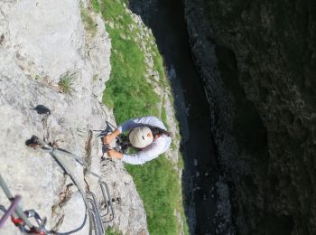
Via ferrata
Altra attività
Altra attività
Altra attività
Altra attività
Altra attività
11 percorsi visualizzati su 11
Applicazione GPS da escursionismo GRATUITA
 SityTrail
IGN / Istituti geografici
SityTrail World
Il mondo è tuo