![](/images/other/stat-length.png)
- Percorsi
- A piedi
- Germany
- Renania-Palatinato
- Landkreis Vulkaneifel
Landkreis Vulkaneifel, Renania-Palatinato, A piedi : I migliori sentieri, percorsi e passeggiate
Landkreis Vulkaneifel: Scopri i migliori percorsi: 24 a piedi e 28 marcia. Tutti questi percorsi, itinerari e attività outdoor sono disponibili nelle nostre app SityTrail per smartphone e tablet.
I percorsi migliori (0})
![Percorso A piedi Wallenborn - HeimatSpur Wallenborner Weg - Photo](https://media.geolcdn.com/t/350/260/08414572-6267-479b-9e5f-5501dfbc3e83.jpeg&format=jpg&maxdim=2)
![A piedi A piedi](https://static1.geolcdn.com/sitytour/trail-icons/100.png)
Km
A piedi
![](/images/other/stat-length.png)
![](https://static1.geolcdn.com/siteimages/upload/files/1508320355ic_sort_den_pos_24dp.png)
![](https://static1.geolcdn.com/siteimages/upload/files/1508320355ic_sort_den_neg_24dp.png)
![](https://static1.geolcdn.com/siteimages/upload/files/16400158638029165_repeat_loop_refresh_sync_direction_icon.png)
• Trail created by Eifel Tourismus.
![Percorso A piedi Daun - HeimatSpur Großer Dauner - Photo](https://media.geolcdn.com/t/350/260/c7f2fcb7-dac5-4db8-bc46-541d9f834168.jpeg&format=jpg&maxdim=2)
![A piedi A piedi](https://static1.geolcdn.com/sitytour/trail-icons/100.png)
Km
A piedi
![](/images/other/stat-length.png)
![](https://static1.geolcdn.com/siteimages/upload/files/1508320355ic_sort_den_pos_24dp.png)
![](https://static1.geolcdn.com/siteimages/upload/files/1508320355ic_sort_den_neg_24dp.png)
![](https://static1.geolcdn.com/siteimages/upload/files/16400158638029165_repeat_loop_refresh_sync_direction_icon.png)
• Trail created by Eifel Tourismus.
![Percorso A piedi Üdersdorf - HeimatSpur Wasser- und Felsenweg - Photo](https://media.geolcdn.com/t/350/260/2a06d58d-a40a-4c3b-9920-9399a98721d8.jpeg&format=jpg&maxdim=2)
![A piedi A piedi](https://static1.geolcdn.com/sitytour/trail-icons/100.png)
Km
A piedi
![](/images/other/stat-length.png)
![](https://static1.geolcdn.com/siteimages/upload/files/1508320355ic_sort_den_pos_24dp.png)
![](https://static1.geolcdn.com/siteimages/upload/files/1508320355ic_sort_den_neg_24dp.png)
![](https://static1.geolcdn.com/siteimages/upload/files/16400158638029165_repeat_loop_refresh_sync_direction_icon.png)
• Trail created by Eifel Tourismus.
![Percorso A piedi Niederstadtfeld - HeimatSpur 1000-jähriger Weg - Photo](https://media.geolcdn.com/t/350/260/61236137-3a2a-4eba-a67c-81ce289debec.jpeg&format=jpg&maxdim=2)
![A piedi A piedi](https://static1.geolcdn.com/sitytour/trail-icons/100.png)
Km
A piedi
![](/images/other/stat-length.png)
![](https://static1.geolcdn.com/siteimages/upload/files/1508320355ic_sort_den_pos_24dp.png)
![](https://static1.geolcdn.com/siteimages/upload/files/1508320355ic_sort_den_neg_24dp.png)
![](https://static1.geolcdn.com/siteimages/upload/files/16400158638029165_repeat_loop_refresh_sync_direction_icon.png)
• Trail created by Eifel Tourismus.
![Percorso A piedi Steineberg - HeimatSpur Keltenrundweg - Photo](https://media.geolcdn.com/t/350/260/4b1692aa-f11b-4d67-8202-607607da5a44.jpeg&format=jpg&maxdim=2)
![A piedi A piedi](https://static1.geolcdn.com/sitytour/trail-icons/100.png)
Km
A piedi
![](/images/other/stat-length.png)
![](https://static1.geolcdn.com/siteimages/upload/files/1508320355ic_sort_den_pos_24dp.png)
![](https://static1.geolcdn.com/siteimages/upload/files/1508320355ic_sort_den_neg_24dp.png)
![](https://static1.geolcdn.com/siteimages/upload/files/16400158638029165_repeat_loop_refresh_sync_direction_icon.png)
• Trail created by Eifel Tourismus. Symbol: grünes rechteck mit KE in weißer Schrift
![Percorso A piedi Strohn - Rundweg Strohner Schweiz - Photo](https://media.geolcdn.com/t/350/260/0d85f9aa-8c27-4f78-b3f2-bfe04930aefe.jpeg&format=jpg&maxdim=2)
![A piedi A piedi](https://static1.geolcdn.com/sitytour/trail-icons/100.png)
Km
A piedi
![](/images/other/stat-length.png)
![](https://static1.geolcdn.com/siteimages/upload/files/1508320355ic_sort_den_pos_24dp.png)
![](https://static1.geolcdn.com/siteimages/upload/files/1508320355ic_sort_den_neg_24dp.png)
![](https://static1.geolcdn.com/siteimages/upload/files/16400158638029165_repeat_loop_refresh_sync_direction_icon.png)
• Trail created by Eifelverein.
![Percorso A piedi Strohn - HeimatSpur Lavaweg Strohn - Photo](https://media.geolcdn.com/t/350/260/f09be04d-a256-4442-9159-f0968e97baeb.jpeg&format=jpg&maxdim=2)
![A piedi A piedi](https://static1.geolcdn.com/sitytour/trail-icons/100.png)
Km
A piedi
![](/images/other/stat-length.png)
![](https://static1.geolcdn.com/siteimages/upload/files/1508320355ic_sort_den_pos_24dp.png)
![](https://static1.geolcdn.com/siteimages/upload/files/1508320355ic_sort_den_neg_24dp.png)
![](https://static1.geolcdn.com/siteimages/upload/files/16400158638029165_repeat_loop_refresh_sync_direction_icon.png)
• Trail created by Eifel Tourismus.
![Percorso A piedi Steffeln - Georundweg Steffeln - Photo](https://media.geolcdn.com/t/350/260/2dd48710-1fdf-44c6-86c1-df2458f9f525.jpeg&format=jpg&maxdim=2)
![A piedi A piedi](https://static1.geolcdn.com/sitytour/trail-icons/100.png)
Km
A piedi
![](/images/other/stat-length.png)
![](https://static1.geolcdn.com/siteimages/upload/files/1508320355ic_sort_den_pos_24dp.png)
![](https://static1.geolcdn.com/siteimages/upload/files/1508320355ic_sort_den_neg_24dp.png)
![](https://static1.geolcdn.com/siteimages/upload/files/16400158638029165_repeat_loop_refresh_sync_direction_icon.png)
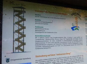
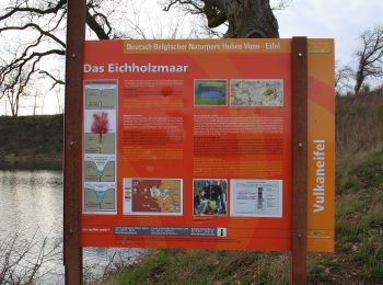
• eichholzmaar, steffeln, duppach, vulkangarten, geo, rundweg, wandern, vulakneifel, natur, geologie, maare, dreese, vu...
![Percorso A piedi Gerolstein - Gerolsteiner Keltenpfad - Photo](https://media.geolcdn.com/t/350/260/702d393f-231f-41c2-907f-13868b96b901.jpeg&format=jpg&maxdim=2)
![A piedi A piedi](https://static1.geolcdn.com/sitytour/trail-icons/100.png)
Km
A piedi
![](/images/other/stat-length.png)
![](https://static1.geolcdn.com/siteimages/upload/files/1508320355ic_sort_den_pos_24dp.png)
![](https://static1.geolcdn.com/siteimages/upload/files/1508320355ic_sort_den_neg_24dp.png)
![](https://static1.geolcdn.com/siteimages/upload/files/16400158638029165_repeat_loop_refresh_sync_direction_icon.png)
• Der Gerolsteiner Keltenpfad ist ein Wanderweg in der Eifel rund um Gerolstein. Wegbeschreibung, Wanderkarte, Höhenpro...
![Percorso A piedi Gerolstein - Gerolsteiner Felsenpfad - Photo](https://media.geolcdn.com/t/350/260/15a3db22-5820-45b4-9fd9-4f37b568139b.jpeg&format=jpg&maxdim=2)
![A piedi A piedi](https://static1.geolcdn.com/sitytour/trail-icons/100.png)
Km
A piedi
![](/images/other/stat-length.png)
![](https://static1.geolcdn.com/siteimages/upload/files/1508320355ic_sort_den_pos_24dp.png)
![](https://static1.geolcdn.com/siteimages/upload/files/1508320355ic_sort_den_neg_24dp.png)
![](https://static1.geolcdn.com/siteimages/upload/files/16400158638029165_repeat_loop_refresh_sync_direction_icon.png)
• Der Gerolsteiner Felsenpfad ist ein Wanderweg in der Eifel rund um Gerolstein. Wegbeschreibung, Wanderkarte, Höhenpro...
![Percorso A piedi Birresborn - Bertrada Route - Photo](https://media.geolcdn.com/t/350/260/88c24b6a-7f61-496b-8b0a-2d0fd807ca49.jpeg&format=jpg&maxdim=2)
![A piedi A piedi](https://static1.geolcdn.com/sitytour/trail-icons/100.png)
Km
A piedi
![](/images/other/stat-length.png)
![](https://static1.geolcdn.com/siteimages/upload/files/1508320355ic_sort_den_pos_24dp.png)
![](https://static1.geolcdn.com/siteimages/upload/files/1508320355ic_sort_den_neg_24dp.png)
![](https://static1.geolcdn.com/siteimages/upload/files/16400158638029165_repeat_loop_refresh_sync_direction_icon.png)
• Trail created by Tourist-Information Gerolsteiner Land. Symbol: "Rote Turmburg in wwasserstehend oben in schwarzer S...
![Percorso A piedi Schalkenmehren - HeimatSpur Maareglück - Photo](https://media.geolcdn.com/t/350/260/cbd6f176-1f85-46b9-810b-a27d08e42f51.jpeg&format=jpg&maxdim=2)
![A piedi A piedi](https://static1.geolcdn.com/sitytour/trail-icons/100.png)
Km
A piedi
![](/images/other/stat-length.png)
![](https://static1.geolcdn.com/siteimages/upload/files/1508320355ic_sort_den_pos_24dp.png)
![](https://static1.geolcdn.com/siteimages/upload/files/1508320355ic_sort_den_neg_24dp.png)
![](https://static1.geolcdn.com/siteimages/upload/files/16400158638029165_repeat_loop_refresh_sync_direction_icon.png)
• Trail created by Eifel Tourismus. Symbol: green:green::MA:white
![Percorso A piedi Ellscheid - HeimatSpur Antoniusweg - Photo](https://media.geolcdn.com/t/350/260/e2ac7d32-3d28-4bd5-b014-b033b8555420.jpeg&format=jpg&maxdim=2)
![A piedi A piedi](https://static1.geolcdn.com/sitytour/trail-icons/100.png)
Km
A piedi
![](/images/other/stat-length.png)
![](https://static1.geolcdn.com/siteimages/upload/files/1508320355ic_sort_den_pos_24dp.png)
![](https://static1.geolcdn.com/siteimages/upload/files/1508320355ic_sort_den_neg_24dp.png)
![](https://static1.geolcdn.com/siteimages/upload/files/16400158638029165_repeat_loop_refresh_sync_direction_icon.png)
• Trail created by Eifel Tourismus. Symbol: grünes rechteck mit AN in weißer Schrift
![Percorso A piedi Strohn - Määrchenweg - Photo](https://media.geolcdn.com/t/350/260/f09be04d-a256-4442-9159-f0968e97baeb.jpeg&format=jpg&maxdim=2)
![A piedi A piedi](https://static1.geolcdn.com/sitytour/trail-icons/100.png)
Km
A piedi
![](/images/other/stat-length.png)
![](https://static1.geolcdn.com/siteimages/upload/files/1508320355ic_sort_den_pos_24dp.png)
![](https://static1.geolcdn.com/siteimages/upload/files/1508320355ic_sort_den_neg_24dp.png)
![](https://static1.geolcdn.com/siteimages/upload/files/16400158638029165_repeat_loop_refresh_sync_direction_icon.png)
• Trail created by Eifelverein.
![Percorso A piedi Jünkerath - Jünkerath (Burgruine & Stauseen) - Photo](https://media.geolcdn.com/t/350/260/fc4fb1d4-03e8-4973-b0fd-25ac2fec27ad.jpeg&format=jpg&maxdim=2)
![A piedi A piedi](https://static1.geolcdn.com/sitytour/trail-icons/100.png)
Km
A piedi
![](/images/other/stat-length.png)
![](https://static1.geolcdn.com/siteimages/upload/files/1508320355ic_sort_den_pos_24dp.png)
![](https://static1.geolcdn.com/siteimages/upload/files/1508320355ic_sort_den_neg_24dp.png)
![](https://static1.geolcdn.com/siteimages/upload/files/16400158638029165_repeat_loop_refresh_sync_direction_icon.png)
• Trail created by Eifelverein. Symbol: schwarze J3 auf weißem Grund
![Percorso A piedi Jünkerath - Bisselbachtal - Photo](https://media.geolcdn.com/t/350/260/3f1d35e0-7262-41a7-a897-a3f2505f7004.jpeg&format=jpg&maxdim=2)
![A piedi A piedi](https://static1.geolcdn.com/sitytour/trail-icons/100.png)
Km
A piedi
![](/images/other/stat-length.png)
![](https://static1.geolcdn.com/siteimages/upload/files/1508320355ic_sort_den_pos_24dp.png)
![](https://static1.geolcdn.com/siteimages/upload/files/1508320355ic_sort_den_neg_24dp.png)
![](https://static1.geolcdn.com/siteimages/upload/files/16400158638029165_repeat_loop_refresh_sync_direction_icon.png)
• Trail created by Eifelverein. Symbol: Schwarze J6 auf weißem Grund
![Percorso A piedi Schalkenmehren - Lieserpfad - Photo](https://media.geolcdn.com/t/350/260/53574610-aaca-459d-b253-05eac0ad6a61.jpeg&format=jpg&maxdim=2)
![A piedi A piedi](https://static1.geolcdn.com/sitytour/trail-icons/100.png)
Km
A piedi
![](/images/other/stat-length.png)
![](https://static1.geolcdn.com/siteimages/upload/files/1508320355ic_sort_den_pos_24dp.png)
![](https://static1.geolcdn.com/siteimages/upload/files/1508320355ic_sort_den_neg_24dp.png)
![](https://static1.geolcdn.com/siteimages/upload/files/16400158638029165_repeat_loop_refresh_sync_direction_icon.png)
• Trail created by Eifelverein. Symbol: Schwarzes Dreieck, Spitze nach links, auf weißem Grund
![Percorso Marcia Pelm - Dolomites de Gerolstein (Eifel) - Photo](https://media.geolcdn.com/t/350/260/bc5670f7-5ecd-4c4d-8448-5f29a634bb1b.jpeg&format=jpg&maxdim=2)
![Marcia Marcia](https://static1.geolcdn.com/sitytour/trail-icons/101.png)
Km
Marcia
![](/images/other/stat-length.png)
![](https://static1.geolcdn.com/siteimages/upload/files/1508320355ic_sort_den_pos_24dp.png)
![](https://static1.geolcdn.com/siteimages/upload/files/1508320355ic_sort_den_neg_24dp.png)
![](https://static1.geolcdn.com/siteimages/upload/files/16400158638029165_repeat_loop_refresh_sync_direction_icon.png)
![Percorso Marcia Daun - Les 3 Maars de Daun (Eifel) - Photo](https://media.geolcdn.com/t/350/260/61bd873f-19aa-487d-992d-48eb1acfb1df.jpeg&format=jpg&maxdim=2)
![Marcia Marcia](https://static1.geolcdn.com/sitytour/trail-icons/101.png)
Km
Marcia
![](/images/other/stat-length.png)
![](https://static1.geolcdn.com/siteimages/upload/files/1508320355ic_sort_den_pos_24dp.png)
![](https://static1.geolcdn.com/siteimages/upload/files/1508320355ic_sort_den_neg_24dp.png)
![](https://static1.geolcdn.com/siteimages/upload/files/16400158638029165_repeat_loop_refresh_sync_direction_icon.png)
![Percorso A piedi Darscheid - HeimatSpur Pfad der Artenvielfalt - Photo](https://media.geolcdn.com/t/350/260/46945c2e-932f-4377-b136-a41388844541.jpeg&format=jpg&maxdim=2)
![A piedi A piedi](https://static1.geolcdn.com/sitytour/trail-icons/100.png)
Km
A piedi
![](/images/other/stat-length.png)
![](https://static1.geolcdn.com/siteimages/upload/files/1508320355ic_sort_den_pos_24dp.png)
![](https://static1.geolcdn.com/siteimages/upload/files/1508320355ic_sort_den_neg_24dp.png)
![](https://static1.geolcdn.com/siteimages/upload/files/16400158638029165_repeat_loop_refresh_sync_direction_icon.png)
• Trail created by Natur-Erlebnis-Zentrum Darscheid. Symbol: Rote Eule Sito web: http://www.darscheid.nez-vulkaneife...
20 percorsi visualizzati su 52
Applicazione GPS da escursionismo GRATUITA
Attività
Regioni vicine
- Basberg
- Beinhausen
- Berlingen
- Birgel
- Birresborn
- Bleckhausen
- Boxberg
- Brockscheid
- Darscheid
- Daun
- Deudesfeld
- Dreis-Brück
- Ellscheid
- Gefell
- Gelenberg
- Gerolstein
- Gillenfeld
- Gunderath
- Hillesheim
- Immerath
- Jünkerath
- Kelberg
- Kerpen (Eifel)
- Kopp
- Mehren
- Mosbruch
- Nerdlen
- Neroth
- Niederstadtfeld
- Nohn
- Oberbettingen
- Oberehe-Stroheich
- Oberstadtfeld
- Pelm
- Reuth
- Salm
- Schalkenmehren
- Stadtkyll
- Steffeln
- Steineberg
- Strohn
- Strotzbüsch
- Üdersdorf
- Üxheim
- Wallenborn
- Walsdorf
- Wiesbaum
- Winkel (Eifel)