![](/images/other/stat-length.png)
Burgbernheim, Landkreis Neustadt an der Aisch-Bad Windsheim, A piedi : I migliori sentieri, percorsi e passeggiate
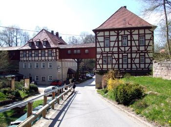
Burgbernheim: Scopri i migliori percorsi: 10 a piedi. Tutti questi percorsi, itinerari e attività outdoor sono disponibili nelle nostre app SityTrail per smartphone e tablet.
I percorsi migliori (0})
![Percorso A piedi Burgbernheim - Nordic-Walking-Strecke Birkensumpf - Photo](https://media.geolcdn.com/t/350/260/82399683-7c89-4c22-ba52-774eeba51623.jpeg&format=jpg&maxdim=2)
![A piedi A piedi](https://static1.geolcdn.com/sitytour/trail-icons/100.png)
Km
A piedi
![](/images/other/stat-length.png)
![](https://static1.geolcdn.com/siteimages/upload/files/1508320355ic_sort_den_pos_24dp.png)
![](https://static1.geolcdn.com/siteimages/upload/files/1508320355ic_sort_den_neg_24dp.png)
![](https://static1.geolcdn.com/siteimages/upload/files/16400158638029165_repeat_loop_refresh_sync_direction_icon.png)
• Trail created by Gemeinde Burgbernheim. Symbol: Weiße 8 auf schwarzem Punkt
![Percorso A piedi Burgbernheim - Rundweg Elster Burgbernheim - Photo](https://media.geolcdn.com/t/350/260/82399683-7c89-4c22-ba52-774eeba51623.jpeg&format=jpg&maxdim=2)
![A piedi A piedi](https://static1.geolcdn.com/sitytour/trail-icons/100.png)
Km
A piedi
![](/images/other/stat-length.png)
![](https://static1.geolcdn.com/siteimages/upload/files/1508320355ic_sort_den_pos_24dp.png)
![](https://static1.geolcdn.com/siteimages/upload/files/1508320355ic_sort_den_neg_24dp.png)
![](https://static1.geolcdn.com/siteimages/upload/files/16400158638029165_repeat_loop_refresh_sync_direction_icon.png)
• Trail created by Gemeinde Burgbernheim. Symbol: Elster auf gelbem Hintergrund
![Percorso A piedi Burgbernheim - Markgrafenweg Burgbernheim - Photo](https://media.geolcdn.com/t/350/260/82399683-7c89-4c22-ba52-774eeba51623.jpeg&format=jpg&maxdim=2)
![A piedi A piedi](https://static1.geolcdn.com/sitytour/trail-icons/100.png)
Km
A piedi
![](/images/other/stat-length.png)
![](https://static1.geolcdn.com/siteimages/upload/files/1508320355ic_sort_den_pos_24dp.png)
![](https://static1.geolcdn.com/siteimages/upload/files/1508320355ic_sort_den_neg_24dp.png)
![](https://static1.geolcdn.com/siteimages/upload/files/16400158638029165_repeat_loop_refresh_sync_direction_icon.png)
• Trail created by Gemeinde Burgbernheim. Symbol: Markgrafenwappen
![Percorso A piedi Burgbernheim - Rundweg Fuchs Burgbernheim - Photo](https://media.geolcdn.com/t/350/260/82399683-7c89-4c22-ba52-774eeba51623.jpeg&format=jpg&maxdim=2)
![A piedi A piedi](https://static1.geolcdn.com/sitytour/trail-icons/100.png)
Km
A piedi
![](/images/other/stat-length.png)
![](https://static1.geolcdn.com/siteimages/upload/files/1508320355ic_sort_den_pos_24dp.png)
![](https://static1.geolcdn.com/siteimages/upload/files/1508320355ic_sort_den_neg_24dp.png)
![](https://static1.geolcdn.com/siteimages/upload/files/16400158638029165_repeat_loop_refresh_sync_direction_icon.png)
• Trail created by Gemeinde Burgbernheim. Symbol: Fuchs auf gelbem Hintergrund
![Percorso A piedi Burgbernheim - Rundweg Eichhörnchen Burgbernheim - Photo](https://media.geolcdn.com/t/350/260/82399683-7c89-4c22-ba52-774eeba51623.jpeg&format=jpg&maxdim=2)
![A piedi A piedi](https://static1.geolcdn.com/sitytour/trail-icons/100.png)
Km
A piedi
![](/images/other/stat-length.png)
![](https://static1.geolcdn.com/siteimages/upload/files/1508320355ic_sort_den_pos_24dp.png)
![](https://static1.geolcdn.com/siteimages/upload/files/1508320355ic_sort_den_neg_24dp.png)
![](https://static1.geolcdn.com/siteimages/upload/files/16400158638029165_repeat_loop_refresh_sync_direction_icon.png)
• Trail created by Gemeinde Burgbernheim. Symbol: Eichhörnchen auf gelbem Hintergrund
![Percorso A piedi Burgbernheim - Nordic-Walking-Strecke Tiefenbach - Photo](https://media.geolcdn.com/t/350/260/82399683-7c89-4c22-ba52-774eeba51623.jpeg&format=jpg&maxdim=2)
![A piedi A piedi](https://static1.geolcdn.com/sitytour/trail-icons/100.png)
Km
A piedi
![](/images/other/stat-length.png)
![](https://static1.geolcdn.com/siteimages/upload/files/1508320355ic_sort_den_pos_24dp.png)
![](https://static1.geolcdn.com/siteimages/upload/files/1508320355ic_sort_den_neg_24dp.png)
![](https://static1.geolcdn.com/siteimages/upload/files/16400158638029165_repeat_loop_refresh_sync_direction_icon.png)
• Trail created by Gemeinde Burgbernheim. Symbol: Weiße 8 auf rotem Punkt
![Percorso A piedi Burgbernheim - Rundweg Waldohreule Burgbernheim - Photo](https://media.geolcdn.com/t/350/260/82399683-7c89-4c22-ba52-774eeba51623.jpeg&format=jpg&maxdim=2)
![A piedi A piedi](https://static1.geolcdn.com/sitytour/trail-icons/100.png)
Km
A piedi
![](/images/other/stat-length.png)
![](https://static1.geolcdn.com/siteimages/upload/files/1508320355ic_sort_den_pos_24dp.png)
![](https://static1.geolcdn.com/siteimages/upload/files/1508320355ic_sort_den_neg_24dp.png)
![](https://static1.geolcdn.com/siteimages/upload/files/16400158638029165_repeat_loop_refresh_sync_direction_icon.png)
• Trail created by Gemeinde Burgbernheim. Symbol: Waldohreule auf gelbem Hintergrund
![Percorso A piedi Burgbernheim - Rundweg Reh Burgbernheim - Photo](https://media.geolcdn.com/t/350/260/82399683-7c89-4c22-ba52-774eeba51623.jpeg&format=jpg&maxdim=2)
![A piedi A piedi](https://static1.geolcdn.com/sitytour/trail-icons/100.png)
Km
A piedi
![](/images/other/stat-length.png)
![](https://static1.geolcdn.com/siteimages/upload/files/1508320355ic_sort_den_pos_24dp.png)
![](https://static1.geolcdn.com/siteimages/upload/files/1508320355ic_sort_den_neg_24dp.png)
![](https://static1.geolcdn.com/siteimages/upload/files/16400158638029165_repeat_loop_refresh_sync_direction_icon.png)
• Trail created by Gemeinde Burgbernheim. Symbol: Reh auf gelbem Hintergrund
![Percorso A piedi Burgbernheim - Rundweg Feuersalamander Burgbernheim - Photo](https://media.geolcdn.com/t/350/260/82399683-7c89-4c22-ba52-774eeba51623.jpeg&format=jpg&maxdim=2)
![A piedi A piedi](https://static1.geolcdn.com/sitytour/trail-icons/100.png)
Km
A piedi
![](/images/other/stat-length.png)
![](https://static1.geolcdn.com/siteimages/upload/files/1508320355ic_sort_den_pos_24dp.png)
![](https://static1.geolcdn.com/siteimages/upload/files/1508320355ic_sort_den_neg_24dp.png)
![](https://static1.geolcdn.com/siteimages/upload/files/16400158638029165_repeat_loop_refresh_sync_direction_icon.png)
• Trail created by Gemeinde Burgbernheim. Symbol: Feuersalamander auf gelbem Hintergrund
![Percorso A piedi Burgbernheim - Rundweg Kirsche Burgbernheim - Photo](https://media.geolcdn.com/t/350/260/ext.jpg?maxdim=2&url=https%3A%2F%2Fstatic1.geolcdn.com%2Fsiteimages%2Fupload%2Ffiles%2F1545311037marcheuse_200dpi.jpg)
![A piedi A piedi](https://static1.geolcdn.com/sitytour/trail-icons/100.png)
Km
A piedi
![](/images/other/stat-length.png)
![](https://static1.geolcdn.com/siteimages/upload/files/1508320355ic_sort_den_pos_24dp.png)
![](https://static1.geolcdn.com/siteimages/upload/files/1508320355ic_sort_den_neg_24dp.png)
![](https://static1.geolcdn.com/siteimages/upload/files/16400158638029165_repeat_loop_refresh_sync_direction_icon.png)
• Trail created by Gemeinde Burgbernheim. Symbol: Kirsche auf gelbem Hintergrund
10 percorsi visualizzati su 10
Applicazione GPS da escursionismo GRATUITA