![](/images/other/stat-length.png)
- Percorsi
- A piedi
- Germany
- Baviera
- Landkreis Main-Spessart
- Steinfeld
Steinfeld, Landkreis Main-Spessart, A piedi : I migliori sentieri, percorsi e passeggiate
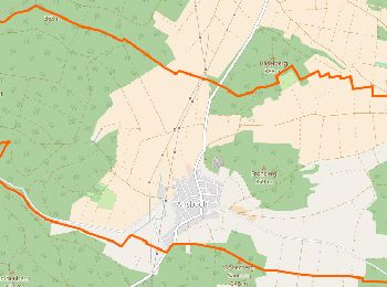
Steinfeld: Scopri i migliori percorsi: 6 a piedi. Tutti questi percorsi, itinerari e attività outdoor sono disponibili nelle nostre app SityTrail per smartphone e tablet.
I percorsi migliori (0})
![Percorso A piedi Steinfeld - Kulturweg Waldsassengau 2 - Photo](https://media.geolcdn.com/t/350/260/d1a7d55f-0430-4d47-b1fd-70d37ed38f7d.jpeg&format=jpg&maxdim=2)
![A piedi A piedi](https://static1.geolcdn.com/sitytour/trail-icons/100.png)
Km
A piedi
![](/images/other/stat-length.png)
![](https://static1.geolcdn.com/siteimages/upload/files/1508320355ic_sort_den_pos_24dp.png)
![](https://static1.geolcdn.com/siteimages/upload/files/1508320355ic_sort_den_neg_24dp.png)
![](https://static1.geolcdn.com/siteimages/upload/files/16400158638029165_repeat_loop_refresh_sync_direction_icon.png)
• Trail created by Archäologisches Spessartprojekt. Symbol: Gelbes EU-Schiffchen auf blauem Grund Sito web: https://...
![Percorso A piedi Steinfeld - Methusalem Wanderweg Blaue Route - Photo](https://media.geolcdn.com/t/350/260/831a1998-9adc-46c3-b0b4-98cd96c2acc8.jpeg&format=jpg&maxdim=2)
![A piedi A piedi](https://static1.geolcdn.com/sitytour/trail-icons/100.png)
Km
A piedi
![](/images/other/stat-length.png)
![](https://static1.geolcdn.com/siteimages/upload/files/1508320355ic_sort_den_pos_24dp.png)
![](https://static1.geolcdn.com/siteimages/upload/files/1508320355ic_sort_den_neg_24dp.png)
![](https://static1.geolcdn.com/siteimages/upload/files/16400158638029165_repeat_loop_refresh_sync_direction_icon.png)
• Trail created by Amt für Ernährung, Landwirtschaft und Forsten Karlstadt. Sito web: http://www.steinfeld-msp.de/se...
![Percorso A piedi Steinfeld - Landwirtschaftlicher Rundweg Steinfeld - Photo](https://media.geolcdn.com/t/350/260/db41c6ff-0fbc-4994-905a-82642a4e0810.jpeg&format=jpg&maxdim=2)
![A piedi A piedi](https://static1.geolcdn.com/sitytour/trail-icons/100.png)
Km
A piedi
![](/images/other/stat-length.png)
![](https://static1.geolcdn.com/siteimages/upload/files/1508320355ic_sort_den_pos_24dp.png)
![](https://static1.geolcdn.com/siteimages/upload/files/1508320355ic_sort_den_neg_24dp.png)
![](https://static1.geolcdn.com/siteimages/upload/files/16400158638029165_repeat_loop_refresh_sync_direction_icon.png)
• Trail created by Arbeitsgruppe Landwirtschaft der 1200 Jahr Feier Steinfeld.
![Percorso A piedi Steinfeld - Methusalem Wanderweg - Photo](https://media.geolcdn.com/t/350/260/ext.jpg?maxdim=2&url=https%3A%2F%2Fstatic1.geolcdn.com%2Fsiteimages%2Fupload%2Ffiles%2F1545311037marcheuse_200dpi.jpg)
![A piedi A piedi](https://static1.geolcdn.com/sitytour/trail-icons/100.png)
Km
A piedi
![](/images/other/stat-length.png)
![](https://static1.geolcdn.com/siteimages/upload/files/1508320355ic_sort_den_pos_24dp.png)
![](https://static1.geolcdn.com/siteimages/upload/files/1508320355ic_sort_den_neg_24dp.png)
![](https://static1.geolcdn.com/siteimages/upload/files/16400158638029165_repeat_loop_refresh_sync_direction_icon.png)
• Trail created by Amt für Ernährung, Landwirtschaft und Forsten Karlstadt. Sito web: http://www.steinfeld-msp.de/se...
![Percorso A piedi Steinfeld - Methusalem Wanderweg Orange Route - Photo](https://media.geolcdn.com/t/350/260/ext.jpg?maxdim=2&url=https%3A%2F%2Fstatic1.geolcdn.com%2Fsiteimages%2Fupload%2Ffiles%2F1545311037marcheuse_200dpi.jpg)
![A piedi A piedi](https://static1.geolcdn.com/sitytour/trail-icons/100.png)
Km
A piedi
![](/images/other/stat-length.png)
![](https://static1.geolcdn.com/siteimages/upload/files/1508320355ic_sort_den_pos_24dp.png)
![](https://static1.geolcdn.com/siteimages/upload/files/1508320355ic_sort_den_neg_24dp.png)
![](https://static1.geolcdn.com/siteimages/upload/files/16400158638029165_repeat_loop_refresh_sync_direction_icon.png)
• Trail created by Amt für Ernährung, Landwirtschaft und Forsten Karlstadt. Sito web: http://www.steinfeld-msp.de/se...
![Percorso A piedi Steinfeld - Archäologischer Wanderweg - Photo](https://media.geolcdn.com/t/350/260/ext.jpg?maxdim=2&url=https%3A%2F%2Fstatic1.geolcdn.com%2Fsiteimages%2Fupload%2Ffiles%2F1545311037marcheuse_200dpi.jpg)
![A piedi A piedi](https://static1.geolcdn.com/sitytour/trail-icons/100.png)
Km
A piedi
![](/images/other/stat-length.png)
![](https://static1.geolcdn.com/siteimages/upload/files/1508320355ic_sort_den_pos_24dp.png)
![](https://static1.geolcdn.com/siteimages/upload/files/1508320355ic_sort_den_neg_24dp.png)
![](https://static1.geolcdn.com/siteimages/upload/files/16400158638029165_repeat_loop_refresh_sync_direction_icon.png)
• Trail created by Heimat- und Geschichtsverein Steinfeld-Hausen-Waldzell. Sito web: https://hgv-steinfeld.de/arch-w...
6 percorsi visualizzati su 6
Applicazione GPS da escursionismo GRATUITA