![](/images/other/stat-length.png)
- Percorsi
- A piedi
- Austria
- Bassa Austria
- Bezirk Neunkirchen
- Gemeinde Seebenstein
Gemeinde Seebenstein, Bezirk Neunkirchen, A piedi : I migliori sentieri, percorsi e passeggiate
Gemeinde Seebenstein: Scopri i migliori percorsi: 7 a piedi. Tutti questi percorsi, itinerari e attività outdoor sono disponibili nelle nostre app SityTrail per smartphone e tablet.
I percorsi migliori (0})
![Percorso A piedi Gemeinde Seebenstein - Pittental Hochwechsel Rundwanderweg 3 - Photo](https://media.geolcdn.com/t/350/260/bec888b9-de6c-4918-847c-285910c1a278.jpeg&format=jpg&maxdim=2)
![A piedi A piedi](https://static1.geolcdn.com/sitytour/trail-icons/100.png)
Km
A piedi
![](/images/other/stat-length.png)
![](https://static1.geolcdn.com/siteimages/upload/files/1508320355ic_sort_den_pos_24dp.png)
![](https://static1.geolcdn.com/siteimages/upload/files/1508320355ic_sort_den_neg_24dp.png)
![](https://static1.geolcdn.com/siteimages/upload/files/16400158638029165_repeat_loop_refresh_sync_direction_icon.png)
• Symbol: Abbildung eines Schuh's auf grünem Schild + 3
![Percorso A piedi Gemeinde Seebenstein - Seebenstein Bahnhof - Waldlehrpfad - Schiltern - Pitten - Photo](https://media.geolcdn.com/t/350/260/c21ad7c5-7ce7-450b-9771-ec9390475d48.jpeg&format=jpg&maxdim=2)
![A piedi A piedi](https://static1.geolcdn.com/sitytour/trail-icons/100.png)
Km
A piedi
![](/images/other/stat-length.png)
![](https://static1.geolcdn.com/siteimages/upload/files/1508320355ic_sort_den_pos_24dp.png)
![](https://static1.geolcdn.com/siteimages/upload/files/1508320355ic_sort_den_neg_24dp.png)
![](https://static1.geolcdn.com/siteimages/upload/files/16400158638029165_repeat_loop_refresh_sync_direction_icon.png)
• Trail created by Österreichischer Touristenklub + Touristenverein "Die Naturfreunde" Ortsgruppe Pitten. Symbol: grün...
![Percorso A piedi Gemeinde Seebenstein - Scheiblingkirchen: Naturparkrunde - Photo](https://media.geolcdn.com/t/350/260/d9494102-eedc-4a1e-bc51-c5b421c3e5d3.jpeg&format=jpg&maxdim=2)
![A piedi A piedi](https://static1.geolcdn.com/sitytour/trail-icons/100.png)
Km
A piedi
![](/images/other/stat-length.png)
![](https://static1.geolcdn.com/siteimages/upload/files/1508320355ic_sort_den_pos_24dp.png)
![](https://static1.geolcdn.com/siteimages/upload/files/1508320355ic_sort_den_neg_24dp.png)
![](https://static1.geolcdn.com/siteimages/upload/files/16400158638029165_repeat_loop_refresh_sync_direction_icon.png)
• Trail created by Marktgemeinde Scheiblingkirchen-Thernberg. Symbol: grün, Beschrifung: Naturparkrunde

![Percorso A piedi Gemeinde Seebenstein - Seebenstein - Scheiblingkirchen - Photo](https://media.geolcdn.com/t/350/260/71576771-aee6-4a0d-aee4-1fa4d8722512.jpeg&format=jpg&maxdim=2)
![A piedi A piedi](https://static1.geolcdn.com/sitytour/trail-icons/100.png)
Km
A piedi
![](/images/other/stat-length.png)
![](https://static1.geolcdn.com/siteimages/upload/files/1508320355ic_sort_den_pos_24dp.png)
![](https://static1.geolcdn.com/siteimages/upload/files/1508320355ic_sort_den_neg_24dp.png)
![](https://static1.geolcdn.com/siteimages/upload/files/16400158638029165_repeat_loop_refresh_sync_direction_icon.png)
• Trail created by Österreichischer Touristenklub, Sektion Neunkirchen. Symbol: roter, waagrechter Balken
![Percorso A piedi Gemeinde Seebenstein - Seebenstein - Sollgraben über Türkensturz oder über Alm - Photo](https://media.geolcdn.com/t/350/260/bd253ddc-783f-493a-917c-48dcd643f1cf.jpeg&format=jpg&maxdim=2)
![A piedi A piedi](https://static1.geolcdn.com/sitytour/trail-icons/100.png)
Km
A piedi
![](/images/other/stat-length.png)
![](https://static1.geolcdn.com/siteimages/upload/files/1508320355ic_sort_den_pos_24dp.png)
![](https://static1.geolcdn.com/siteimages/upload/files/1508320355ic_sort_den_neg_24dp.png)
![](https://static1.geolcdn.com/siteimages/upload/files/16400158638029165_repeat_loop_refresh_sync_direction_icon.png)
• Symbol: grüner, waagrechter Balken
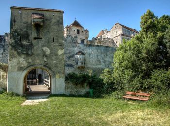
![Percorso A piedi Gemeinde Seebenstein - Seebenstein - Weingart über Burg Seebenstein - Photo](https://media.geolcdn.com/t/350/260/3e661856-3b05-44b2-90c7-6e32f6da757d.jpeg&format=jpg&maxdim=2)
![A piedi A piedi](https://static1.geolcdn.com/sitytour/trail-icons/100.png)
Km
A piedi
![](/images/other/stat-length.png)
![](https://static1.geolcdn.com/siteimages/upload/files/1508320355ic_sort_den_pos_24dp.png)
![](https://static1.geolcdn.com/siteimages/upload/files/1508320355ic_sort_den_neg_24dp.png)
![](https://static1.geolcdn.com/siteimages/upload/files/16400158638029165_repeat_loop_refresh_sync_direction_icon.png)
• Trail created by Österreichischer Touristenklub, Zentrale Wien. Symbol: roter, waagrechter Balken
![Percorso A piedi Gemeinde Seebenstein - Schiltern (Bachgrabenweg) - Arzberg - Stanghof - Photo](https://media.geolcdn.com/t/350/260/ext.jpg?maxdim=2&url=https%3A%2F%2Fstatic1.geolcdn.com%2Fsiteimages%2Fupload%2Ffiles%2F1545311037marcheuse_200dpi.jpg)
![A piedi A piedi](https://static1.geolcdn.com/sitytour/trail-icons/100.png)
Km
A piedi
![](/images/other/stat-length.png)
![](https://static1.geolcdn.com/siteimages/upload/files/1508320355ic_sort_den_pos_24dp.png)
![](https://static1.geolcdn.com/siteimages/upload/files/1508320355ic_sort_den_neg_24dp.png)
![](https://static1.geolcdn.com/siteimages/upload/files/16400158638029165_repeat_loop_refresh_sync_direction_icon.png)
• Symbol: roter, waagrechter Balken
7 percorsi visualizzati su 7
Applicazione GPS da escursionismo GRATUITA