chris83330

Offline

Favoris publics

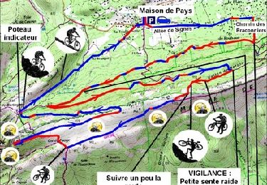
Randonnée V.T.T. Signes - vallon oure - Photo
V.T.T.
marcodesignes

V.T.T.

Très facile
Signes, Provence-Alpes-Côte d'Azur, Var, France
19,5 km | 26 km-effort
Inconnu
Non
Randonnée V.T.T. Plan-d'Aups-Sainte-Baume - Pic de Bertagne - Plan d'Aups - Photo
V.T.T.
tracegps

V.T.T.

Difficile
Plan-d'Aups-Sainte-Baume, Provence-Alpes-Côte d'Azur, Var, France
17,9 km | 25 km-effort
3h 0min
Oui
Randonnée V.T.T. Ollioules - Chez Gérard  - Photo
V.T.T.
FERAUD

V.T.T.

Difficile
(3)
Ollioules, Provence-Alpes-Côte d'Azur, Var, France
22 km | 32 km-effort
3h 37min
Oui
Randonnée V.T.T. Plan-d'Aups-Sainte-Baume - Sainte Baume - Sentier Poucel - Photo
V.T.T.
tracegps

V.T.T.

Moyen
Plan-d'Aups-Sainte-Baume, Provence-Alpes-Côte d'Azur, Var, France
20 km | 27 km-effort
3h 30min
Oui
Randonnée V.T.T. Le Beausset - Jeudaï- Maisondes4frères-05Oct2017 - Photo
V.T.T.

V.T.T.

Moyen
Le Beausset, Provence-Alpes-Côte d'Azur, Var, France
22 km | 29 km-effort
1h 52min
Oui
Randonnée V.T.T. Signes - Signes - Photo
V.T.T.
Franz BOFFARD

V.T.T.

Très difficile
Signes, Provence-Alpes-Côte d'Azur, Var, France
31 km | 40 km-effort
3h 43min
Oui
Randonnée V.T.T. Signes - Barres de Cuges - Photo
V.T.T.
Franz BOFFARD

V.T.T.

Moyen
Signes, Provence-Alpes-Côte d'Azur, Var, France
38 km | 48 km-effort
3h 55min
Oui

Fermer
Mes abonnements