Chafoin

Offline
Cuicui

Randonnées

Randonnée A pied École - Du parking des Jarses au col d'Arclusaz - Photo
A pied
Chafoin

A pied

Facile
École, Auvergne-Rhône-Alpes, Savoie, France
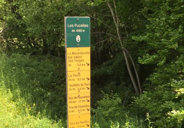
8 km | 16,1 km-effort
3h 38min
Non
Randonnée Marche École - Vers le col d'Arclusaz - Photo
Marche
Chafoin

Marche

Facile
École, Auvergne-Rhône-Alpes, Savoie, France
3,2 km | 5,8 km-effort
1h 19min
Non
Randonnée A pied École - Col d'Arclusaz ( Aller ) - Photo
A pied
Chafoin

A pied

Facile
École, Auvergne-Rhône-Alpes, Savoie, France
7,6 km | 17,3 km-effort
3h 56min
Non
Randonnée sport Izeron - G3 montchardon - Photo
sport
Chafoin

sport

Très facile
Izeron, Auvergne-Rhône-Alpes, Isère, France
12 km | 21 km-effort
Inconnu
Oui
Randonnée A pied Thoiry - La pointe de la Galoppaz (1680 nm) du col des Prés ( 1043 m ) - Photo
A pied
Chafoin

A pied

Facile
Thoiry, Auvergne-Rhône-Alpes, Savoie, France
8,8 km | 17,9 km-effort
4h 4min
Oui
Randonnée sport Charavines - Charavines_G3-G4 - Photo
sport
Chafoin

sport

Très facile
Charavines, Auvergne-Rhône-Alpes, Isère, France
8,5 km | 11 km-effort
Inconnu
Oui
Randonnée A pied La Thuile - Lac de la Thuile-Manettaz-Roche du Guet-Le Tapin - Photo
A pied
Chafoin

A pied

Facile
La Thuile, Auvergne-Rhône-Alpes, Savoie, France
8 km | 12,8 km-effort
2h 53min
Oui
Randonnée A pied Autrans-Méaudre en Vercors - Bec de l' Orient - Photo
A pied
Chafoin

A pied

Facile
Autrans-Méaudre en Vercors, Auvergne-Rhône-Alpes, Isère, France
9 km | 14,1 km-effort
3h 12min
Oui
Randonnée A pied Theys - Autour du Grand Rocher - Photo
A pied
Chafoin

A pied

Moyen
Theys, Auvergne-Rhône-Alpes, Isère, France
12,1 km | 20 km-effort
4h 34min
Oui
Randonnée A pied Gresse-en-Vercors - Un petit tour au Grand Brisou - Photo
A pied
Chafoin

A pied

Facile
Gresse-en-Vercors, Auvergne-Rhône-Alpes, Isère, France
9,3 km | 15,8 km-effort
3h 36min
Oui
Randonnée Marche Saint-Nizier-du-Moucherotte - Un petit AR sur le sentier du Périmètre  - Photo
Marche
Chafoin

Marche

Saint-Nizier-du-Moucherotte, Auvergne-Rhône-Alpes, Isère, France
6,1 km | 10,5 km-effort
1h 48min
Oui
Randonnée A pied Saint-Laurent-du-Pont - LA Crête des Charmilles ( A Salvi Chartreuse N°22 p . 83 croquis p .80 ) ) - Photo
A pied
Chafoin

A pied

Moyen
Saint-Laurent-du-Pont, Auvergne-Rhône-Alpes, Isère, France
10,5 km | 21 km-effort
4h 47min
Oui
Randonnée A pied Saint-Michel-les-Portes - Au tour (sic !) du Goutaroux et de l'Aubeyron - Photo
A pied
Chafoin

A pied

Moyen
Saint-Michel-les-Portes, Auvergne-Rhône-Alpes, Isère, France
11,4 km | 19,3 km-effort
4h 22min
Oui
Randonnée Marche Apremont - Du col du Granier vers le Mt Joigny et la Bornée - Photo
Marche
Chafoin

Marche

Moyen
Apremont, Auvergne-Rhône-Alpes, Savoie, France
7,7 km | 13,9 km-effort
3h 9min
Oui
Randonnée Marche Saint-Christophe-en-Oisans - Refuge de la Lavey lac des Bêches - Photo
Marche
Chafoin

Marche

Moyen
Saint-Christophe-en-Oisans, Auvergne-Rhône-Alpes, Isère, France
7,7 km | 18,2 km-effort
4h 7min
Non
Randonnée Marche Chantepérier - Du Périer aux Daurens  en passant par le Touret (1564 m) - Photo
Marche
Chafoin

Marche

Moyen
Chantepérier, Auvergne-Rhône-Alpes, Isère, France
7,5 km | 16,3 km-effort
3h 42min
Non
Randonnée Marche Chichilianne - du Pas de l'Aiguille au pas de l'Essaure - Photo
Marche
Chafoin

Marche

Moyen
Chichilianne, Auvergne-Rhône-Alpes, Isère, France
10,7 km | 19,9 km-effort
4h 31min
Non
Randonnée A pied Valbonnais - Canal et Crêtes du Beaumont - Photo
A pied
Chafoin

A pied

Moyen
Valbonnais, Auvergne-Rhône-Alpes, Isère, France
15,4 km | 26 km-effort
3h 0min
Oui
Randonnée A pied Saint-Martin-d'Hères - Autour du Bigot - Photo
A pied
Chafoin

A pied

Facile
Saint-Martin-d'Hères, Auvergne-Rhône-Alpes, Isère, France
5,3 km | 7,7 km-effort
Inconnu
Oui

Fermer
Mes abonnements