Randonnée Marche Saint-Amarin - Marche Vallée de Thur - Photo

Marche Vallée de Thur

 Schaff
Schaff

Utilisateur

© OpenStreetMap contributors
Longueur
Longueur
73 km
Altitude max
Altitude max
1268 m
Dénivelé positif
Dénivelé positif
2715 m
Km-Effort
Km-Effort  
109 km
Altitude min
Altitude min
401 m
Dénivelé négatif
Dénivelé négatif
2716 m
Boucle
Boucle
Oui
Date de création :
2019-01-15 12:22:05.309
Dernière modification :
2019-01-15 12:22:05.309

(0 Avis)

Marche
Marche
17h23
Difficulté : Très difficile

Scannez ce code QR pour ouvrir la randonnée dans l'application SityTrail

Application GPS de randonnée GRATUITE

Logo SityTrail SityTrail

IGN / Instituts géographiques

Télécharger SityTrail sur l'App Store Télécharger SityTrail sur Google Play

Logo SityTrail SityTrail World

Le monde est à vous

Télécharger SityTrail sur l'App Store Télécharger SityTrail sur Google Play Télécharger SityTrail sur Huawei AppGallery

À propos

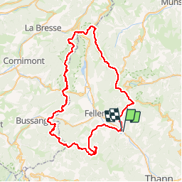
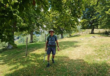
Randonnée Marche de 73 km à découvrir à Grand Est, Haut-Rhin, Saint-Amarin. Cette randonnée est proposée par Schaff.

Description

Dur et longue pour des marcheurs amateurs et surveillés par les organisateurs  et volontaires du Tour de La Vallée de la Thur

Profil altimétrique

Photos

Localisation

Pays :
France
Région :
Grand Est
Département/Province :
Haut-Rhin
Commune :
Saint-Amarin
Localité :
Unknown
Départ:(Dec)
Départ:(UTM)
352854 ; 5303948 (32T) N.

Randonnées à proximité

Randonnée A pied Bitschwiller-lès-Thann - Bitschwiller les Thann - Rehbrunnel - Abri du Becherkopf - Roche Albert - Photo
A pied
patrickbeyrath

A pied

Moyen
(1)
Bitschwiller-lès-Thann, Grand Est, Haut-Rhin, France
10,3 km | 16,4 km-effort
Inconnu
Oui
Randonnée Marche Oderen - TREK ALSACIEN (boucle, la meute) - Photo
Marche
Godasses et Grosses Pattes

Marche

Difficile
Oderen, Grand Est, Haut-Rhin, France
14,3 km | 23 km-effort
4h 30min
Oui
Randonnée Marche Oderen - Oderen Bergenbach Langenbach - Photo
Marche
geishouse

Marche

Moyen
Oderen, Grand Est, Haut-Rhin, France
7,1 km | 11,6 km-effort
3h 40min
Non
Randonnée Marche Mollau - Le rossberg - Photo
Marche
margotte

Marche

Moyen
Mollau, Grand Est, Haut-Rhin, France
14,9 km | 25 km-effort
7h 41min
Oui
Randonnée Marche Oderen - TREK ALSACIEN (1ère étape) - Photo
Marche
Godasses et Grosses Pattes

Marche

Moyen
Oderen, Grand Est, Haut-Rhin, France
9,2 km | 18,1 km-effort
4h 0min
Non
Randonnée Marche Ranspach - Rando des Marcheurs 20/07/2023 - Photo
Marche
boubou68

Marche

Très difficile
Ranspach, Grand Est, Haut-Rhin, France
23 km | 38 km-effort
5h 31min
Oui
Randonnée Marche Saint-Amarin - dimanche - Photo
Marche
Ninie38MD

Marche

Très difficile
(1)
Saint-Amarin, Grand Est, Haut-Rhin, France
19,4 km | 35 km-effort
7h 51min
Oui
Randonnée Marche Moosch - Moosch Haag - Photo
Marche
Estelle Handschin

Marche

Difficile
(1)
Moosch, Grand Est, Haut-Rhin, France
21 km | 0 m-effort
5h 27min
Oui
Randonnée Marche Oderen -  TREK ALSACIEN (boucle, Odin) - Photo
Marche
Godasses et Grosses Pattes

Marche

Moyen
Oderen, Grand Est, Haut-Rhin, France
8,5 km | 12,9 km-effort
2h 56min
Oui


Fermer
Mes abonnements