![](/images/other/stat-length.png)
![Randonnée Marche Hyères - Porquerolles par Henri Antoine - Photo](https://media.geolcdn.com/t/1900/400/ext.pjpeg?maxdim=2&url=https%3A%2F%2Fservices.sitytrail.com%2FGeolivesWS%2FDownloadMedia.ashx%3FTrailID%3D995795%26Media%3D20180619150930.jpg)
Porquerolles par Henri Antoine
henriantoine
Utilisateur
![Longueur](/images/other/stat-length.png)
Longueur
9,5 km
![Altitude max](https://static1.geolcdn.com/siteimages/upload/files/1508320355ic_sort_altitude_max_24dp.png)
Altitude max
68 m
![Dénivelé positif](https://static1.geolcdn.com/siteimages/upload/files/1508320355ic_sort_den_pos_24dp.png)
Dénivelé positif
199 m
![Km-Effort](/images/other/stat-length.png)
Km-Effort
12,2 km
![Altitude min](https://static1.geolcdn.com/siteimages/upload/files/1508320355ic_sort_altitude_min_24dp.png)
Altitude min
6 m
![Dénivelé négatif](https://static1.geolcdn.com/siteimages/upload/files/1508320355ic_sort_den_neg_24dp.png)
Dénivelé négatif
198 m
![Boucle](https://static1.geolcdn.com/siteimages/upload/files/16400158638029165_repeat_loop_refresh_sync_direction_icon.png)
Boucle
Oui
Date de création :
2018-09-11 10:15:35.187
Dernière modification :
2018-09-11 10:15:35.187
![Marche](https://static1.geolcdn.com/sitytour/trail-icons/101.png)
2h36
Difficulté : Moyen
![Scannez ce code QR pour ouvrir la randonnée dans l'application SityTrail](https://capi.geolives.com/qq0zvz2zws4bq2lad0pu/sitytour/trails/995795/qr.png?size=200)
Application GPS de randonnée GRATUITE
À propos
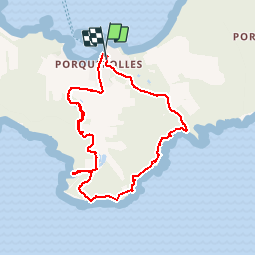
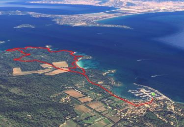
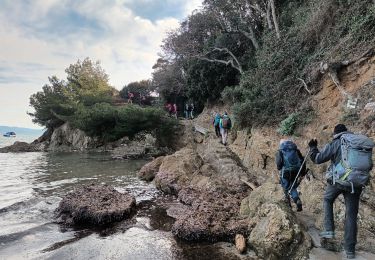
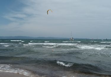
Randonnée Marche de 9,5 km à découvrir à Provence-Alpes-Côte d'Azur, Var, Hyères. Cette randonnée est proposée par henriantoine.
Description
Une des ombreuses possibilités de randonnée accessible en distance et en efforts a tout marcheurs normal. superbe boucles mettant en valeur la nature et les cotes maritimes superbes et sauvages de cette île attirante
Localisation
Pays :
France
Région :
Provence-Alpes-Côte d'Azur
Département/Province :
Var
Commune :
Hyères
Localité :
Unknown
Départ:(Dec)
Départ:(UTM)
272051 ; 4764750 (32T) N.
Commentaires
Randonnées à proximité
![Randonnée Marche Hyères - Presqu'ile de Giens coté Est (version longue) - Photo](https://media.geolcdn.com/t/375/260/ext.jpg?maxdim=2&url=https%3A%2F%2Fmedia.geolcdn.com%2Ff%2F111e178c-db2d-4519-839d-89c97a7ddc38.jpg)
![Marche Marche](https://static1.geolcdn.com/sitytour/trail-icons/101.png)
Presqu'ile de Giens coté Est (version longue)
Marche
Facile
(2)
Hyères,
Provence-Alpes-Côte d'Azur,
Var,
France
![](/images/other/stat-length.png)
11,9 km | 14,2 km-effort
4h 0min
![](https://static1.geolcdn.com/siteimages/upload/files/16400158638029165_repeat_loop_refresh_sync_direction_icon.png)
Oui
![Randonnée Marche Hyères - Tour Fondue - La Madrague - Photo](https://media.geolcdn.com/t/375/260/ext.jpg?maxdim=2&url=https%3A%2F%2Fservices.sitytrail.com%2FGeolivesWS%2FDownloadMedia.ashx%3FTrailID%3D408792%26Media%3Dfix__20150414183437.jpg)
![Marche Marche](https://static1.geolcdn.com/sitytour/trail-icons/101.png)
Tour Fondue - La Madrague
Marche
Très facile
(1)
Hyères,
Provence-Alpes-Côte d'Azur,
Var,
France
![](/images/other/stat-length.png)
7,7 km | 10,5 km-effort
1h 51min
![](https://static1.geolcdn.com/siteimages/upload/files/16400158638029165_repeat_loop_refresh_sync_direction_icon.png)
Non
![Randonnée Marche Hyères - Ile de Porquerolles - Photo](https://media.geolcdn.com/t/375/260/ext.jpg?maxdim=2&url=https%3A%2F%2Fmedia.geolcdn.com%2Ff%2Fa1c0ccd3-737f-48da-a3f1-3d7559d679bf.jpg)
![Marche Marche](https://static1.geolcdn.com/sitytour/trail-icons/101.png)
Ile de Porquerolles
Marche
Très facile
Hyères,
Provence-Alpes-Côte d'Azur,
Var,
France
![](/images/other/stat-length.png)
9,4 km | 11,3 km-effort
3h 0min
![](https://static1.geolcdn.com/siteimages/upload/files/16400158638029165_repeat_loop_refresh_sync_direction_icon.png)
Oui
![Randonnée Marche Hyères - Tour de la Presqu'île de Giens-05-04-23 - Photo](https://media.geolcdn.com/t/375/260/ext.jpg?maxdim=2&url=https%3A%2F%2Fmedia.geolcdn.com%2Ff%2F14c5260e-a78f-4087-82e6-20738fb1aa89.jpg)
![Marche Marche](https://static1.geolcdn.com/sitytour/trail-icons/101.png)
Tour de la Presqu'île de Giens-05-04-23
Marche
Moyen
Hyères,
Provence-Alpes-Côte d'Azur,
Var,
France
![](/images/other/stat-length.png)
21 km | 28 km-effort
5h 49min
![](https://static1.geolcdn.com/siteimages/upload/files/16400158638029165_repeat_loop_refresh_sync_direction_icon.png)
Oui
![Randonnée V.T.T. Hyères - 83 porquerolles - Photo](https://media.geolcdn.com/t/375/260/ext.jpg?maxdim=2&url=https%3A%2F%2Fmedia.geolcdn.com%2Ff%2Ff1373d3a-3c7f-4956-b2e9-fceb4ddd92ad.jpg)
![V.T.T. V.T.T.](https://static1.geolcdn.com/sitytour/trail-icons/202.png)
83 porquerolles
V.T.T.
Facile
Hyères,
Provence-Alpes-Côte d'Azur,
Var,
France
![](/images/other/stat-length.png)
28 km | 34 km-effort
5h 33min
![](https://static1.geolcdn.com/siteimages/upload/files/16400158638029165_repeat_loop_refresh_sync_direction_icon.png)
Non
![Randonnée Marche Hyères - Presqu'île de Giens est-03-06-22 - Photo](https://media.geolcdn.com/t/375/260/ext.jpg?maxdim=2&url=https%3A%2F%2Fmedia.geolcdn.com%2Ff%2Fc844f258-4d5d-4c60-bd4a-d27d3e19e122.jpg)
![Marche Marche](https://static1.geolcdn.com/sitytour/trail-icons/101.png)
Presqu'île de Giens est-03-06-22
Marche
Moyen
Hyères,
Provence-Alpes-Côte d'Azur,
Var,
France
![](/images/other/stat-length.png)
7,1 km | 8,3 km-effort
2h 40min
![](https://static1.geolcdn.com/siteimages/upload/files/16400158638029165_repeat_loop_refresh_sync_direction_icon.png)
Oui
![Randonnée Marche Hyères - Porquerolles - Photo](https://media.geolcdn.com/t/375/260/ext.jpg?maxdim=2&url=https%3A%2F%2Fmedia.geolcdn.com%2Ff%2Ff3396ed8-c944-4ad3-a27c-027176be03ea.heic)
![Marche Marche](https://static1.geolcdn.com/sitytour/trail-icons/101.png)
Porquerolles
Marche
Moyen
Hyères,
Provence-Alpes-Côte d'Azur,
Var,
France
![](/images/other/stat-length.png)
11,5 km | 14,3 km-effort
2h 40min
![](https://static1.geolcdn.com/siteimages/upload/files/16400158638029165_repeat_loop_refresh_sync_direction_icon.png)
Oui
![Randonnée Marche Hyères - Presqu'île de Giens - Photo](https://media.geolcdn.com/t/375/260/ext.jpg?maxdim=2&url=https%3A%2F%2Fmedia.geolcdn.com%2Ff%2Fd99cb6ec-3473-41c8-ab6f-a769bbdddcae.jpg)
![Marche Marche](https://static1.geolcdn.com/sitytour/trail-icons/101.png)
Presqu'île de Giens
Marche
Moyen
Hyères,
Provence-Alpes-Côte d'Azur,
Var,
France
![](/images/other/stat-length.png)
8,3 km | 10 km-effort
3h 15min
![](https://static1.geolcdn.com/siteimages/upload/files/16400158638029165_repeat_loop_refresh_sync_direction_icon.png)
Oui
![Randonnée Marche Hyères - La Badine sentier côtier Hyères - Photo](https://media.geolcdn.com/t/375/260/ext.jpg?maxdim=2&url=https%3A%2F%2Fmedia.geolcdn.com%2Ff%2Fb1b9796b-40ac-4856-bd47-3622b514169a.jpg)
![Marche Marche](https://static1.geolcdn.com/sitytour/trail-icons/101.png)
La Badine sentier côtier Hyères
Marche
Moyen
Hyères,
Provence-Alpes-Côte d'Azur,
Var,
France
![](/images/other/stat-length.png)
10,8 km | 13,2 km-effort
3h 21min
![](https://static1.geolcdn.com/siteimages/upload/files/16400158638029165_repeat_loop_refresh_sync_direction_icon.png)
Oui