![](/images/other/stat-length.png)
![Randonnée Marche Saint-Étienne-de-Tinée - Pas de Colle Longue par Douans - Photo](https://media.geolcdn.com/t/1900/400/ext.pjpeg?maxdim=2&url=https%3A%2F%2Fstatic1.geolcdn.com%2Fsiteimages%2Fupload%2Ffiles%2F1553511878bg_sport_marche.png)
Pas de Colle Longue par Douans
GrouGary
Utilisateur
![Longueur](/images/other/stat-length.png)
Longueur
15,3 km
![Altitude max](https://static1.geolcdn.com/siteimages/upload/files/1508320355ic_sort_altitude_max_24dp.png)
Altitude max
2542 m
![Dénivelé positif](https://static1.geolcdn.com/siteimages/upload/files/1508320355ic_sort_den_pos_24dp.png)
Dénivelé positif
1281 m
![Km-Effort](/images/other/stat-length.png)
Km-Effort
32 km
![Altitude min](https://static1.geolcdn.com/siteimages/upload/files/1508320355ic_sort_altitude_min_24dp.png)
Altitude min
1308 m
![Dénivelé négatif](https://static1.geolcdn.com/siteimages/upload/files/1508320355ic_sort_den_neg_24dp.png)
Dénivelé négatif
1279 m
![Boucle](https://static1.geolcdn.com/siteimages/upload/files/16400158638029165_repeat_loop_refresh_sync_direction_icon.png)
Boucle
Oui
Date de création :
2018-06-26 16:32:02.852
Dernière modification :
2018-06-26 16:32:02.852
![Marche](https://static1.geolcdn.com/sitytour/trail-icons/101.png)
6h23
Difficulté : Moyen
![Scannez ce code QR pour ouvrir la randonnée dans l'application SityTrail](https://capi.geolives.com/qq0zvz2zws4bq2lad0pu/sitytour/trails/988114/qr.png?size=200)
Application GPS de randonnée GRATUITE
À propos
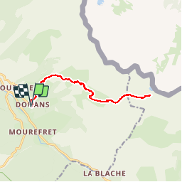
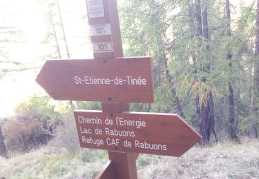
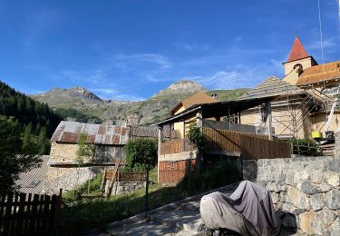
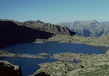
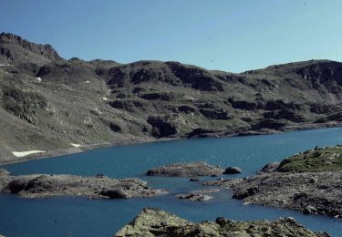
Randonnée Marche de 15,3 km à découvrir à Provence-Alpes-Côte d'Azur, Alpes-Maritimes, Saint-Étienne-de-Tinée. Cette randonnée est proposée par GrouGary.
Description
Une moyenne sans difficultés mais sportive car longue et passage névés en juin. Alpages et fleurs variées(Benoîte des ruisseaux, lys de st Bruno, orchidees, joubarbes...)
Localisation
Pays :
France
Région :
Provence-Alpes-Côte d'Azur
Département/Province :
Alpes-Maritimes
Commune :
Saint-Étienne-de-Tinée
Localité :
Unknown
Départ:(Dec)
Départ:(UTM)
338034 ; 4898310 (32T) N.
Commentaires
Randonnées à proximité
![Randonnée Marche Saint-Étienne-de-Tinée - MERCANTOUR - Lac de rabuons - Photo](https://media.geolcdn.com/t/375/260/9be970a9-36fb-4800-8850-f3d8a283d146.jpg&format=jpg&maxdim=2)
![Marche Marche](https://static1.geolcdn.com/sitytour/trail-icons/101.png)
MERCANTOUR - Lac de rabuons
Marche
Très difficile
(1)
Saint-Étienne-de-Tinée,
Provence-Alpes-Côte d'Azur,
Alpes-Maritimes,
France
![](/images/other/stat-length.png)
19,5 km | 40 km-effort
9h 9min
![](https://static1.geolcdn.com/siteimages/upload/files/16400158638029165_repeat_loop_refresh_sync_direction_icon.png)
Non
![Randonnée Marche Saint-Étienne-de-Tinée - Mont Ténibre en boucle depuis Saint Etienne de Tinée - Photo](https://media.geolcdn.com/t/375/260/ext.jpg?maxdim=2&url=https%3A%2F%2Fservices.sitytrail.com%2FGeolivesWS%2FDownloadMedia.ashx%3FTrailID%3D316962%26Media%3D16081_1.jpg)
![Marche Marche](https://static1.geolcdn.com/sitytour/trail-icons/101.png)
Mont Ténibre en boucle depuis Saint Etienne de Tinée
Marche
Très difficile
(4)
Saint-Étienne-de-Tinée,
Provence-Alpes-Côte d'Azur,
Alpes-Maritimes,
France
![](/images/other/stat-length.png)
18 km | 45 km-effort
10h 0min
![](https://static1.geolcdn.com/siteimages/upload/files/16400158638029165_repeat_loop_refresh_sync_direction_icon.png)
Oui
![Randonnée Marche Saint-Étienne-de-Tinée - Lacs de Rabuons et Chaffour - Photo](https://media.geolcdn.com/t/375/260/3c095966-4d41-4343-af9e-eff2f1957790.jpg&format=jpg&maxdim=2)
![Marche Marche](https://static1.geolcdn.com/sitytour/trail-icons/101.png)
Lacs de Rabuons et Chaffour
Marche
Difficile
Saint-Étienne-de-Tinée,
Provence-Alpes-Côte d'Azur,
Alpes-Maritimes,
France
![](/images/other/stat-length.png)
22 km | 46 km-effort
7h 4min
![](https://static1.geolcdn.com/siteimages/upload/files/16400158638029165_repeat_loop_refresh_sync_direction_icon.png)
Oui
![Randonnée Marche Saint-Étienne-de-Tinée - Réel Roya Col de Crousette Stèle Valette Petit Mounier et Mounier - Photo](https://media.geolcdn.com/t/375/260/b5c86927-6c55-4c7f-afae-58ada10c53b3.jpg&format=jpg&maxdim=2)
![Marche Marche](https://static1.geolcdn.com/sitytour/trail-icons/101.png)
Réel Roya Col de Crousette Stèle Valette Petit Mounier et Mounier
Marche
Très difficile
Saint-Étienne-de-Tinée,
Provence-Alpes-Côte d'Azur,
Alpes-Maritimes,
France
![](/images/other/stat-length.png)
22 km | 42 km-effort
6h 31min
![](https://static1.geolcdn.com/siteimages/upload/files/16400158638029165_repeat_loop_refresh_sync_direction_icon.png)
Oui
![Randonnée A pied Saint-Étienne-de-Tinée - Circuit du Bois d'Anelle - Photo](https://media.geolcdn.com/t/375/260/33170b65-b2a2-4258-939b-53929311e4fe.jpeg&format=jpg&maxdim=2)
![A pied A pied](https://static1.geolcdn.com/sitytour/trail-icons/100.png)
Circuit du Bois d'Anelle
A pied
Moyen
Saint-Étienne-de-Tinée,
Provence-Alpes-Côte d'Azur,
Alpes-Maritimes,
France
![](/images/other/stat-length.png)
11,3 km | 21 km-effort
4h 40min
![](https://static1.geolcdn.com/siteimages/upload/files/16400158638029165_repeat_loop_refresh_sync_direction_icon.png)
Oui
![Randonnée A pied Saint-Étienne-de-Tinée - Circuit de Selasse - Photo](https://media.geolcdn.com/t/375/260/dfb717e2-6ad9-4c5c-8a23-b53a05088fa8.jpeg&format=jpg&maxdim=2)
![A pied A pied](https://static1.geolcdn.com/sitytour/trail-icons/100.png)
Circuit de Selasse
A pied
Facile
Saint-Étienne-de-Tinée,
Provence-Alpes-Côte d'Azur,
Alpes-Maritimes,
France
![](/images/other/stat-length.png)
6,3 km | 15,1 km-effort
3h 25min
![](https://static1.geolcdn.com/siteimages/upload/files/16400158638029165_repeat_loop_refresh_sync_direction_icon.png)
Oui
![Randonnée A pied Saint-Étienne-de-Tinée - Cime de la Bercha - Photo](https://media.geolcdn.com/t/375/260/06e4d46f-e317-406d-bd2c-01041e541c38.jpeg&format=jpg&maxdim=2)
![A pied A pied](https://static1.geolcdn.com/sitytour/trail-icons/100.png)
Cime de la Bercha
A pied
Facile
Saint-Étienne-de-Tinée,
Provence-Alpes-Côte d'Azur,
Alpes-Maritimes,
France
![](/images/other/stat-length.png)
9,3 km | 18,1 km-effort
4h 7min
![](https://static1.geolcdn.com/siteimages/upload/files/16400158638029165_repeat_loop_refresh_sync_direction_icon.png)
Oui
![Randonnée A pied Saint-Étienne-de-Tinée - Mont Ténibre - Photo](https://media.geolcdn.com/t/375/260/e4d2ef1c-7332-48ac-8d35-d330e68b6f30.jpeg&format=jpg&maxdim=2)
![A pied A pied](https://static1.geolcdn.com/sitytour/trail-icons/100.png)
Mont Ténibre
A pied
Très difficile
Saint-Étienne-de-Tinée,
Provence-Alpes-Côte d'Azur,
Alpes-Maritimes,
France
![](/images/other/stat-length.png)
24 km | 52 km-effort
11h 45min
![](https://static1.geolcdn.com/siteimages/upload/files/16400158638029165_repeat_loop_refresh_sync_direction_icon.png)
Oui
![Randonnée A pied Saint-Étienne-de-Tinée - Mont Ténibre - Etape 1 - Photo](https://media.geolcdn.com/t/375/260/0ae9acc1-b5e7-475c-ba30-b123ec5f057b.jpeg&format=jpg&maxdim=2)
![A pied A pied](https://static1.geolcdn.com/sitytour/trail-icons/100.png)
Mont Ténibre - Etape 1
A pied
Moyen
Saint-Étienne-de-Tinée,
Provence-Alpes-Côte d'Azur,
Alpes-Maritimes,
France
![](/images/other/stat-length.png)
8,4 km | 24 km-effort
5h 20min
![](https://static1.geolcdn.com/siteimages/upload/files/16400158638029165_repeat_loop_refresh_sync_direction_icon.png)
Non