![](/images/other/stat-length.png)
![Randonnée Marche Marseille - Callelongue (Escalier geants-Pas du pin, Marseilleveyre, pasde la selle, trois arches, malvallon median, malvallon, col galinette) - Photo](https://media.geolcdn.com/t/1900/400/ext.pjpeg?maxdim=2&url=https%3A%2F%2Fstatic1.geolcdn.com%2Fsiteimages%2Fupload%2Ffiles%2F1553511878bg_sport_marche.png)
Callelongue (Escalier geants-Pas du pin, Marseilleveyre, pasde la selle, trois arches, malvallon median, malvallon, col galinette)
mapomme
Utilisateur
![Longueur](/images/other/stat-length.png)
Longueur
8,7 km
![Altitude max](https://static1.geolcdn.com/siteimages/upload/files/1508320355ic_sort_altitude_max_24dp.png)
Altitude max
417 m
![Dénivelé positif](https://static1.geolcdn.com/siteimages/upload/files/1508320355ic_sort_den_pos_24dp.png)
Dénivelé positif
551 m
![Km-Effort](/images/other/stat-length.png)
Km-Effort
16,1 km
![Altitude min](https://static1.geolcdn.com/siteimages/upload/files/1508320355ic_sort_altitude_min_24dp.png)
Altitude min
8 m
![Dénivelé négatif](https://static1.geolcdn.com/siteimages/upload/files/1508320355ic_sort_den_neg_24dp.png)
Dénivelé négatif
552 m
![Boucle](https://static1.geolcdn.com/siteimages/upload/files/16400158638029165_repeat_loop_refresh_sync_direction_icon.png)
Boucle
Oui
Date de création :
2014-12-10 00:00:00.0
Dernière modification :
2014-12-10 00:00:00.0
![Marche](https://static1.geolcdn.com/sitytour/trail-icons/101.png)
4h00
Difficulté : Moyen
![Scannez ce code QR pour ouvrir la randonnée dans l'application SityTrail](https://capi.geolives.com/qq0zvz2zws4bq2lad0pu/sitytour/trails/98712/qr.png?size=200)
Application GPS de randonnée GRATUITE
À propos
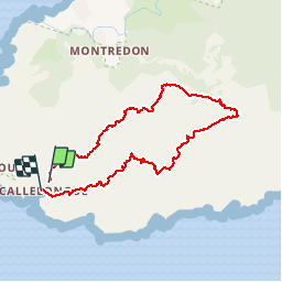
Randonnée Marche de 8,7 km à découvrir à Provence-Alpes-Côte d'Azur, Bouches-du-Rhône, Marseille. Cette randonnée est proposée par mapomme.
Description
Callelongue (Escalier geants-Pas du pin, Marseilleveyre, pasde la selle, trois arches, malvallon median, malvallon, col galinette)
Localisation
Pays :
France
Région :
Provence-Alpes-Côte d'Azur
Département/Province :
Bouches-du-Rhône
Commune :
Marseille
Localité :
8e Arrondissement
Départ:(Dec)
Départ:(UTM)
691301 ; 4787234 (31T) N.
Commentaires
Randonnées à proximité
![Randonnée V.T.T. Marseille - Trilogie des Calanques version courte - Photo](https://media.geolcdn.com/t/375/260/37b85b5c-5918-4ab9-a017-9d4bcff1fa49.jpg&format=jpg&maxdim=2)
![V.T.T. V.T.T.](https://static1.geolcdn.com/sitytour/trail-icons/202.png)
Trilogie des Calanques version courte
V.T.T.
Difficile
(1)
Marseille,
Provence-Alpes-Côte d'Azur,
Bouches-du-Rhône,
France
![](/images/other/stat-length.png)
28 km | 35 km-effort
3h 30min
![](https://static1.geolcdn.com/siteimages/upload/files/16400158638029165_repeat_loop_refresh_sync_direction_icon.png)
Oui
![Randonnée Marche Marseille - Marseilleveyre - Photo](https://media.geolcdn.com/t/375/260/1c6dd8e4-fc3d-455d-ab0a-aecb3f4e28f3.jpg&format=jpg&maxdim=2)
![Marche Marche](https://static1.geolcdn.com/sitytour/trail-icons/101.png)
Marseilleveyre
Marche
Très difficile
Marseille,
Provence-Alpes-Côte d'Azur,
Bouches-du-Rhône,
France
![](/images/other/stat-length.png)
13,8 km | 23 km-effort
6h 7min
![](https://static1.geolcdn.com/siteimages/upload/files/16400158638029165_repeat_loop_refresh_sync_direction_icon.png)
Oui
![Randonnée A pied Marseille - FR-4 - Photo](https://media.geolcdn.com/t/375/260/95b4ab9b-15fa-4206-9283-bece755bce28.jpeg&format=jpg&maxdim=2)
![A pied A pied](https://static1.geolcdn.com/sitytour/trail-icons/100.png)
FR-4
A pied
Facile
Marseille,
Provence-Alpes-Côte d'Azur,
Bouches-du-Rhône,
France
![](/images/other/stat-length.png)
4 km | 7,3 km-effort
1h 39min
![](https://static1.geolcdn.com/siteimages/upload/files/16400158638029165_repeat_loop_refresh_sync_direction_icon.png)
Non
![Randonnée A pied Marseille - FR-1 - Photo](https://media.geolcdn.com/t/375/260/bc3bf1c1-4e6d-4ecd-b741-b7754447ebb3.jpeg&format=jpg&maxdim=2)
![A pied A pied](https://static1.geolcdn.com/sitytour/trail-icons/100.png)
FR-1
A pied
Facile
Marseille,
Provence-Alpes-Côte d'Azur,
Bouches-du-Rhône,
France
![](/images/other/stat-length.png)
3,4 km | 5,8 km-effort
1h 18min
![](https://static1.geolcdn.com/siteimages/upload/files/16400158638029165_repeat_loop_refresh_sync_direction_icon.png)
Non
![Randonnée A pied Marseille - FR-1 - Photo](https://media.geolcdn.com/t/375/260/99184d8a-cb78-4a50-b5ed-c50326639dce.jpeg&format=jpg&maxdim=2)
![A pied A pied](https://static1.geolcdn.com/sitytour/trail-icons/100.png)
FR-1
A pied
Facile
(1)
Marseille,
Provence-Alpes-Côte d'Azur,
Bouches-du-Rhône,
France
![](/images/other/stat-length.png)
7,2 km | 12,8 km-effort
2h 54min
![](https://static1.geolcdn.com/siteimages/upload/files/16400158638029165_repeat_loop_refresh_sync_direction_icon.png)
Non
![Randonnée A pied Marseille - FR-1 - Photo](https://media.geolcdn.com/t/375/260/bc3bf1c1-4e6d-4ecd-b741-b7754447ebb3.jpeg&format=jpg&maxdim=2)
![A pied A pied](https://static1.geolcdn.com/sitytour/trail-icons/100.png)
FR-1
A pied
Facile
Marseille,
Provence-Alpes-Côte d'Azur,
Bouches-du-Rhône,
France
![](/images/other/stat-length.png)
3 km | 7,1 km-effort
1h 37min
![](https://static1.geolcdn.com/siteimages/upload/files/16400158638029165_repeat_loop_refresh_sync_direction_icon.png)
Non
![Randonnée A pied Marseille - FR-1 - Photo](https://media.geolcdn.com/t/375/260/4cd62a7f-c9ca-4a0b-a61b-53cee5136735.jpeg&format=jpg&maxdim=2)
![A pied A pied](https://static1.geolcdn.com/sitytour/trail-icons/100.png)
FR-1
A pied
Facile
Marseille,
Provence-Alpes-Côte d'Azur,
Bouches-du-Rhône,
France
![](/images/other/stat-length.png)
6,3 km | 13,2 km-effort
3h 0min
![](https://static1.geolcdn.com/siteimages/upload/files/16400158638029165_repeat_loop_refresh_sync_direction_icon.png)
Non
![Randonnée A pied Marseille - FR-2 - Photo](https://media.geolcdn.com/t/375/260/4e6398b1-8b18-413e-9aa3-3eda435bcb35.jpeg&format=jpg&maxdim=2)
![A pied A pied](https://static1.geolcdn.com/sitytour/trail-icons/100.png)
FR-2
A pied
Facile
Marseille,
Provence-Alpes-Côte d'Azur,
Bouches-du-Rhône,
France
![](/images/other/stat-length.png)
5,4 km | 9 km-effort
2h 3min
![](https://static1.geolcdn.com/siteimages/upload/files/16400158638029165_repeat_loop_refresh_sync_direction_icon.png)
Non
![Randonnée A pied Marseille - FR-2 - Photo](https://media.geolcdn.com/t/375/260/95b4ab9b-15fa-4206-9283-bece755bce28.jpeg&format=jpg&maxdim=2)
![A pied A pied](https://static1.geolcdn.com/sitytour/trail-icons/100.png)
FR-2
A pied
Facile
Marseille,
Provence-Alpes-Côte d'Azur,
Bouches-du-Rhône,
France
![](/images/other/stat-length.png)
7,8 km | 12,8 km-effort
2h 54min
![](https://static1.geolcdn.com/siteimages/upload/files/16400158638029165_repeat_loop_refresh_sync_direction_icon.png)
Non