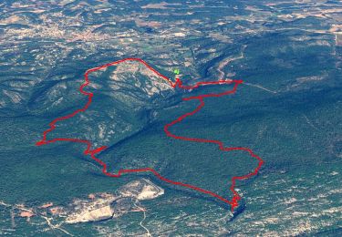
![](/images/other/stat-length.png)
![Randonnée Marche Tourves - chapelle Saint Probace et gorges du caramy - Photo](https://media.geolcdn.com/t/1900/400/ext.pjpeg?maxdim=2&url=https%3A%2F%2Fservices.sitytrail.com%2FGeolivesWS%2FDownloadMedia.ashx%3FTrailID%3D984279%26Media%3Dfix__20180610150603.jpg)
chapelle Saint Probace et gorges du caramy
amiral13
Utilisateur GUIDE
![Longueur](/images/other/stat-length.png)
![Altitude max](https://static1.geolcdn.com/siteimages/upload/files/1508320355ic_sort_altitude_max_24dp.png)
![Dénivelé positif](https://static1.geolcdn.com/siteimages/upload/files/1508320355ic_sort_den_pos_24dp.png)
![Km-Effort](/images/other/stat-length.png)
![Altitude min](https://static1.geolcdn.com/siteimages/upload/files/1508320355ic_sort_altitude_min_24dp.png)
![Dénivelé négatif](https://static1.geolcdn.com/siteimages/upload/files/1508320355ic_sort_den_neg_24dp.png)
![Boucle](https://static1.geolcdn.com/siteimages/upload/files/16400158638029165_repeat_loop_refresh_sync_direction_icon.png)
![Marche](https://static1.geolcdn.com/sitytour/trail-icons/101.png)
3h26
Difficulté : Facile
![Scannez ce code QR pour ouvrir la randonnée dans l'application SityTrail](https://capi.geolives.com/qq0zvz2zws4bq2lad0pu/sitytour/trails/984279/qr.png?size=200)
Application GPS de randonnée GRATUITE
À propos
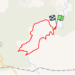
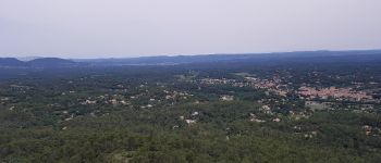
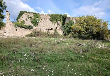
Randonnée Marche de 7,7 km à découvrir à Provence-Alpes-Côte d'Azur, Var, Tourves. Cette randonnée est proposée par amiral13.
Description
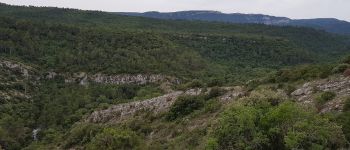
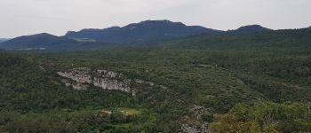
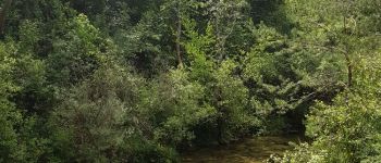
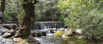
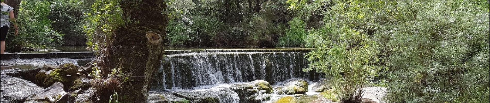
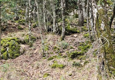
une petite randonnée sur les rives du Caramy.
Du point 1, il est intéressant de remonter le cours de la rivière jusqu'au lieu -dit "sauts du cabri" (route de Mazaugues). D'abord par un bon sentier, puis par une sente et au travers d'un chaos rocheux. A éviter lorsque le débit est trop important. Voir un de mes autres topos ou l'aller se fait par le lit de la rivière et le retour par les crêtes est.
Localisation
Commentaires
Randonnées à proximité
![Randonnée Marche Mazaugues - Mazaugues 21.4.24 - Photo](https://media.geolcdn.com/t/375/260/73ef7019-56c4-45d7-90ef-e1bea2022610.jpg&format=jpg&maxdim=2)
![Marche Marche](https://static1.geolcdn.com/sitytour/trail-icons/101.png)
Marche
![](/images/other/stat-length.png)
![](https://static1.geolcdn.com/siteimages/upload/files/16400158638029165_repeat_loop_refresh_sync_direction_icon.png)
![Randonnée Marche Tourves - Tourves - Les gorges du Caramy - Le Saut du Cabri - Casteleret - Grotte Chuchy - St Probace - Photo](https://media.geolcdn.com/t/375/260/124cbbf2-932c-4737-ad3d-4f1fc25db1d8.jpg&format=jpg&maxdim=2)
![Marche Marche](https://static1.geolcdn.com/sitytour/trail-icons/101.png)
Marche
![](/images/other/stat-length.png)
![](https://static1.geolcdn.com/siteimages/upload/files/16400158638029165_repeat_loop_refresh_sync_direction_icon.png)
![Randonnée Marche Mazaugues - le Mourre d'Agnis au départ du Caucadis - Photo](https://media.geolcdn.com/t/375/260/dcd1794e-c5af-44e1-af91-1fadcb296c68.jpg&format=jpg&maxdim=2)
![Marche Marche](https://static1.geolcdn.com/sitytour/trail-icons/101.png)
Marche
![](/images/other/stat-length.png)
![](https://static1.geolcdn.com/siteimages/upload/files/16400158638029165_repeat_loop_refresh_sync_direction_icon.png)
![Randonnée Marche Mazaugues - Mazaugues le vallon de l'Herbette - Photo](https://media.geolcdn.com/t/375/260/62c4707c-a050-47d0-822e-64a046e156e1.jpg&format=jpg&maxdim=2)
![Marche Marche](https://static1.geolcdn.com/sitytour/trail-icons/101.png)
Marche
![](/images/other/stat-length.png)
![](https://static1.geolcdn.com/siteimages/upload/files/16400158638029165_repeat_loop_refresh_sync_direction_icon.png)
![Marche Marche](https://static1.geolcdn.com/sitytour/trail-icons/101.png)
Marche
![](/images/other/stat-length.png)
![](https://static1.geolcdn.com/siteimages/upload/files/16400158638029165_repeat_loop_refresh_sync_direction_icon.png)
![Randonnée A pied Mazaugues - Mazaugues-Mourre d'Agnis-23-10-2024 - Photo](https://media.geolcdn.com/t/375/260/8bdd9a43-13c3-4a0a-a9d2-ae092f24102a.jpg&format=jpg&maxdim=2)
![A pied A pied](https://static1.geolcdn.com/sitytour/trail-icons/100.png)
A pied
![](/images/other/stat-length.png)
![](https://static1.geolcdn.com/siteimages/upload/files/16400158638029165_repeat_loop_refresh_sync_direction_icon.png)
![Randonnée Marche Mazaugues - De Mazaugues vers la glacière Pivaut - Photo](https://media.geolcdn.com/t/375/260/93cdb635-dd33-4fbf-b53a-783eebba00a2.jpg&format=jpg&maxdim=2)
![Marche Marche](https://static1.geolcdn.com/sitytour/trail-icons/101.png)
Marche
![](/images/other/stat-length.png)
![](https://static1.geolcdn.com/siteimages/upload/files/16400158638029165_repeat_loop_refresh_sync_direction_icon.png)
![Randonnée Marche Tourves - Chapelle Saint Probace-Caramy - Photo](https://media.geolcdn.com/t/375/260/7f1232ec-7969-4983-99a5-20a0dcf4a9ed.jpg&format=jpg&maxdim=2)
![Marche Marche](https://static1.geolcdn.com/sitytour/trail-icons/101.png)
Marche
![](/images/other/stat-length.png)
![](https://static1.geolcdn.com/siteimages/upload/files/16400158638029165_repeat_loop_refresh_sync_direction_icon.png)
![Randonnée Marche Tourves - Caramy version courte - Photo](https://media.geolcdn.com/t/375/260/37415954-4374-47c8-b9b8-5d268df2d30c.jpg&format=jpg&maxdim=2)
![Marche Marche](https://static1.geolcdn.com/sitytour/trail-icons/101.png)
Marche
![](/images/other/stat-length.png)
![](https://static1.geolcdn.com/siteimages/upload/files/16400158638029165_repeat_loop_refresh_sync_direction_icon.png)