![](/images/other/stat-length.png)
![Randonnée Marche Plouzané - Tour Toulbroc'h et Deolen - Photo](https://media.geolcdn.com/t/1900/400/ext.pjpeg?maxdim=2&url=https%3A%2F%2Fservices.sitytrail.com%2FGeolivesWS%2FDownloadMedia.ashx%3FTrailID%3D977485%26Media%3Dfix__20180530181251.jpg)
Tour Toulbroc'h et Deolen
Balades en Finistère
Promenez-vous au bout du monde !
![Longueur](/images/other/stat-length.png)
Longueur
8 km
![Altitude max](https://static1.geolcdn.com/siteimages/upload/files/1508320355ic_sort_altitude_max_24dp.png)
Altitude max
74 m
![Dénivelé positif](https://static1.geolcdn.com/siteimages/upload/files/1508320355ic_sort_den_pos_24dp.png)
Dénivelé positif
145 m
![Km-Effort](/images/other/stat-length.png)
Km-Effort
10 km
![Altitude min](https://static1.geolcdn.com/siteimages/upload/files/1508320355ic_sort_altitude_min_24dp.png)
Altitude min
7 m
![Dénivelé négatif](https://static1.geolcdn.com/siteimages/upload/files/1508320355ic_sort_den_neg_24dp.png)
Dénivelé négatif
144 m
![Boucle](https://static1.geolcdn.com/siteimages/upload/files/16400158638029165_repeat_loop_refresh_sync_direction_icon.png)
Boucle
Oui
Date de création :
2018-07-06 09:45:10.911
Dernière modification :
2018-07-06 09:45:10.911
![Marche](https://static1.geolcdn.com/sitytour/trail-icons/101.png)
2h12
Difficulté : Facile
![Scannez ce code QR pour ouvrir la randonnée dans l'application SityTrail](https://capi.geolives.com/qq0zvz2zws4bq2lad0pu/sitytour/trails/977485/qr.png?size=200)
Application GPS de randonnée GRATUITE
À propos
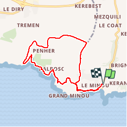
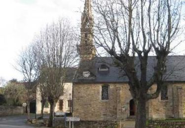
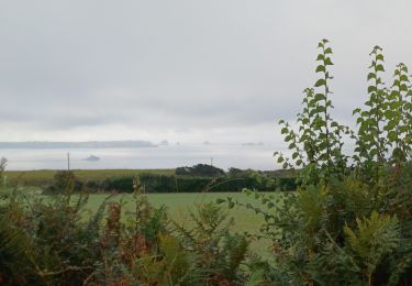
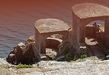
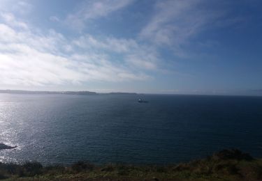
Randonnée Marche de 8 km à découvrir à Bretagne, Finistère, Plouzané. Cette randonnée est proposée par Balades en Finistère.
Description
En partant de la plage du petit Minou, on longe la côte par le GR34 jusque l'anse de Deolen pour revenir au point de départ par des petites routes.
Localisation
Pays :
France
Région :
Bretagne
Département/Province :
Finistère
Commune :
Plouzané
Localité :
Unknown
Départ:(Dec)
Départ:(UTM)
380323 ; 5355416 (30U) N.
Commentaires
Randonnées à proximité
![Randonnée V.T.T. Plouzané - Tournerre de Brest - Photo](https://media.geolcdn.com/t/375/260/ext.jpg?maxdim=2&url=https%3A%2F%2Fservices.sitytrail.com%2FGeolivesWS%2FDownloadMedia.ashx%3FTrailID%3D215094%26Media%3D15674_6.jpg)
![V.T.T. V.T.T.](https://static1.geolcdn.com/sitytour/trail-icons/202.png)
Tournerre de Brest
V.T.T.
Difficile
(1)
Plouzané,
Bretagne,
Finistère,
France
![](/images/other/stat-length.png)
50 km | 58 km-effort
4h 0min
![](https://static1.geolcdn.com/siteimages/upload/files/16400158638029165_repeat_loop_refresh_sync_direction_icon.png)
Oui
![Randonnée Marche Roscanvel - De Roscanvel à la Pointe des Espagnols - Photo](https://media.geolcdn.com/t/375/260/ext.jpg?maxdim=2&url=https%3A%2F%2Fservices.sitytrail.com%2FGeolivesWS%2FDownloadMedia.ashx%3FTrailID%3D109167%26Media%3D3210_1.jpg)
![Marche Marche](https://static1.geolcdn.com/sitytour/trail-icons/101.png)
De Roscanvel à la Pointe des Espagnols
Marche
Moyen
(2)
Roscanvel,
Bretagne,
Finistère,
France
![](/images/other/stat-length.png)
17,7 km | 22 km-effort
2h 30min
![](https://static1.geolcdn.com/siteimages/upload/files/16400158638029165_repeat_loop_refresh_sync_direction_icon.png)
Oui
![Randonnée Marche Roscanvel - La pointe des Espagnols Boucle 18 km - Photo](https://media.geolcdn.com/t/375/260/93ad904e-720a-4417-9e64-50801db79033.jpg&format=jpg&maxdim=2)
![Marche Marche](https://static1.geolcdn.com/sitytour/trail-icons/101.png)
La pointe des Espagnols Boucle 18 km
Marche
Moyen
Roscanvel,
Bretagne,
Finistère,
France
![](/images/other/stat-length.png)
17,6 km | 22 km-effort
4h 12min
![](https://static1.geolcdn.com/siteimages/upload/files/16400158638029165_repeat_loop_refresh_sync_direction_icon.png)
Oui
![Randonnée Marche Locmaria-Plouzané - 11.09.23 Pen Ar Menez -- Brest - Photo](https://media.geolcdn.com/t/375/260/6882fce9-18a5-4c78-a7c4-bc1b88a1a635.jpg&format=jpg&maxdim=2)
![Marche Marche](https://static1.geolcdn.com/sitytour/trail-icons/101.png)
11.09.23 Pen Ar Menez -- Brest
Marche
Très difficile
Locmaria-Plouzané,
Bretagne,
Finistère,
France
![](/images/other/stat-length.png)
22 km | 28 km-effort
6h 25min
![](https://static1.geolcdn.com/siteimages/upload/files/16400158638029165_repeat_loop_refresh_sync_direction_icon.png)
Non
![Randonnée Marche Roscanvel - Quélern - Pointe des Espagnols Boucle GR34 - 20.2km 325m 5h15 (35mn) - 2019 09 10 - Photo](https://media.geolcdn.com/t/375/260/d3722b6e-34eb-4a9e-a2a0-ac45e343e6f5.jpg&format=jpg&maxdim=2)
![Marche Marche](https://static1.geolcdn.com/sitytour/trail-icons/101.png)
Quélern - Pointe des Espagnols Boucle GR34 - 20.2km 325m 5h15 (35mn) - 2019 0...
Marche
Moyen
Roscanvel,
Bretagne,
Finistère,
France
![](/images/other/stat-length.png)
20 km | 25 km-effort
5h 15min
![](https://static1.geolcdn.com/siteimages/upload/files/16400158638029165_repeat_loop_refresh_sync_direction_icon.png)
Oui
![Randonnée Marche Roscanvel - Pointe des Espagnols - Roscanvel - Photo](https://media.geolcdn.com/t/375/260/ext.jpg?maxdim=2&url=https%3A%2F%2Fstatic1.geolcdn.com%2Fsiteimages%2Fupload%2Ffiles%2F1553511878bg_sport_marche.png)
![Marche Marche](https://static1.geolcdn.com/sitytour/trail-icons/101.png)
Pointe des Espagnols - Roscanvel
Marche
Moyen
(2)
Roscanvel,
Bretagne,
Finistère,
France
![](/images/other/stat-length.png)
14,9 km | 18,6 km-effort
3h 19min
![](https://static1.geolcdn.com/siteimages/upload/files/16400158638029165_repeat_loop_refresh_sync_direction_icon.png)
Oui
![Randonnée Marche nordique Locmaria-Plouzané - Plouzané Pen ar c hleus - Photo](https://media.geolcdn.com/t/375/260/340beccd-49b5-4d8f-9e7c-37e017438e9f.jpg&format=jpg&maxdim=2)
![Marche nordique Marche nordique](https://static1.geolcdn.com/sitytour/trail-icons/102.png)
Plouzané Pen ar c hleus
Marche nordique
Très facile
Locmaria-Plouzané,
Bretagne,
Finistère,
France
![](/images/other/stat-length.png)
12,4 km | 15,8 km-effort
2h 47min
![](https://static1.geolcdn.com/siteimages/upload/files/16400158638029165_repeat_loop_refresh_sync_direction_icon.png)
Oui
![Randonnée Marche Roscanvel - boucle pointe espagnole - Photo](https://media.geolcdn.com/t/375/260/f95b8bb0-b672-48a5-a561-b1a849326fcc.jpg&format=jpg&maxdim=2)
![Marche Marche](https://static1.geolcdn.com/sitytour/trail-icons/101.png)
boucle pointe espagnole
Marche
Facile
(1)
Roscanvel,
Bretagne,
Finistère,
France
![](/images/other/stat-length.png)
13,7 km | 16,9 km-effort
3h 19min
![](https://static1.geolcdn.com/siteimages/upload/files/16400158638029165_repeat_loop_refresh_sync_direction_icon.png)
Oui
![Randonnée Marche Roscanvel - ROSCANVEL - Photo](https://media.geolcdn.com/t/375/260/e473e0f7-84f5-406e-8e1c-7cd2e8b078e2.jpg&format=jpg&maxdim=2)
![Marche Marche](https://static1.geolcdn.com/sitytour/trail-icons/101.png)