![](/images/other/stat-length.png)
![Randonnée Marche Esmoulières - Esmoulières 18 960m +448m - Photo](https://media.geolcdn.com/t/1900/400/ext.pjpeg?maxdim=2&url=https%3A%2F%2Fstatic1.geolcdn.com%2Fsiteimages%2Fupload%2Ffiles%2F1553511878bg_sport_marche.png)
Esmoulières 18 960m +448m
DanielROLLET
Utilisateur
![Longueur](/images/other/stat-length.png)
Longueur
19 km
![Altitude max](https://static1.geolcdn.com/siteimages/upload/files/1508320355ic_sort_altitude_max_24dp.png)
Altitude max
672 m
![Dénivelé positif](https://static1.geolcdn.com/siteimages/upload/files/1508320355ic_sort_den_pos_24dp.png)
Dénivelé positif
448 m
![Km-Effort](/images/other/stat-length.png)
Km-Effort
25 km
![Altitude min](https://static1.geolcdn.com/siteimages/upload/files/1508320355ic_sort_altitude_min_24dp.png)
Altitude min
468 m
![Dénivelé négatif](https://static1.geolcdn.com/siteimages/upload/files/1508320355ic_sort_den_neg_24dp.png)
Dénivelé négatif
448 m
![Boucle](https://static1.geolcdn.com/siteimages/upload/files/16400158638029165_repeat_loop_refresh_sync_direction_icon.png)
Boucle
Oui
Date de création :
2018-06-26 14:27:54.309
Dernière modification :
2024-07-01 08:25:57.578
![Marche](https://static1.geolcdn.com/sitytour/trail-icons/101.png)
5h39
Difficulté : Très difficile
![Scannez ce code QR pour ouvrir la randonnée dans l'application SityTrail](https://capi.geolives.com/qq0zvz2zws4bq2lad0pu/sitytour/trails/970507/qr.png?size=200)
Application GPS de randonnée GRATUITE
À propos
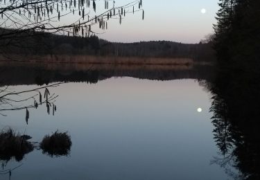
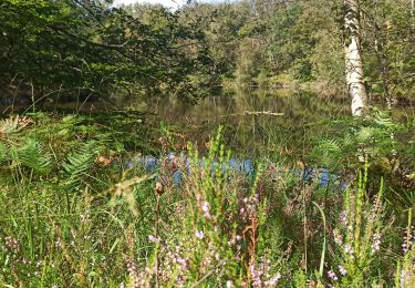
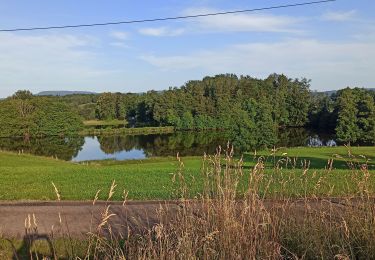
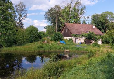
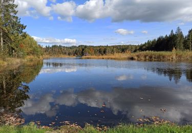
Randonnée Marche de 19 km à découvrir à Bourgogne-Franche-Comté, Haute-Saône, Esmoulières. Cette randonnée est proposée par DanielROLLET.
Description
2018.05.20 - 10:00 à 14:00
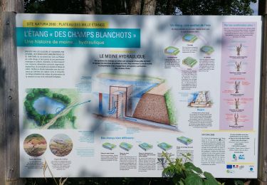
Festival de rando "Mille Pas aux Mille Étangs"
1950 participants
Très beau circuit mais que n'est pas renouvelable car il passe dans des propriétés privées
Arrivée avec la pluie, sinon beau temps couvert.
Localisation
Pays :
France
Région :
Bourgogne-Franche-Comté
Département/Province :
Haute-Saône
Commune :
Esmoulières
Localité :
Unknown
Départ:(Dec)
Départ:(UTM)
321850 ; 5302972 (32T) N.
Commentaires
Randonnées à proximité
![Randonnée Marche Beulotte-Saint-Laurent - Randonnée des étangs - Beulotte Saint Laurent - Photo](https://media.geolcdn.com/t/375/260/ext.jpg?maxdim=2&url=https%3A%2F%2Fservices.sitytrail.com%2FGeolivesWS%2FDownloadMedia.ashx%3FTrailID%3D107231%26Media%3D12098_5.jpg)
![Marche Marche](https://static1.geolcdn.com/sitytour/trail-icons/101.png)
Randonnée des étangs - Beulotte Saint Laurent
Marche
Moyen
(4)
Beulotte-Saint-Laurent,
Bourgogne-Franche-Comté,
Haute-Saône,
France
![](/images/other/stat-length.png)
10,7 km | 13,9 km-effort
2h 30min
![](https://static1.geolcdn.com/siteimages/upload/files/16400158638029165_repeat_loop_refresh_sync_direction_icon.png)
Oui
![Randonnée Marche Faucogney-et-la-Mer - 08-02-20 La mer, étang de Pierre Plate et retour. - Photo](https://media.geolcdn.com/t/375/260/1db8c6b9-2ea1-4f8e-aef5-d4d9373f14e8.jpg&format=jpg&maxdim=2)
![Marche Marche](https://static1.geolcdn.com/sitytour/trail-icons/101.png)
08-02-20 La mer, étang de Pierre Plate et retour.
Marche
Très facile
(1)
Faucogney-et-la-Mer,
Bourgogne-Franche-Comté,
Haute-Saône,
France
![](/images/other/stat-length.png)
9,9 km | 12,3 km-effort
2h 4min
![](https://static1.geolcdn.com/siteimages/upload/files/16400158638029165_repeat_loop_refresh_sync_direction_icon.png)
Oui
![Randonnée Marche Beulotte-Saint-Laurent - Beulotte-Saint-Laurent 13 700m + 317m - Photo](https://media.geolcdn.com/t/375/260/ext.jpg?maxdim=2&url=https%3A%2F%2Fstatic1.geolcdn.com%2Fsiteimages%2Fupload%2Ffiles%2F1553511878bg_sport_marche.png)
![Marche Marche](https://static1.geolcdn.com/sitytour/trail-icons/101.png)
Beulotte-Saint-Laurent 13 700m + 317m
Marche
Facile
(1)
Beulotte-Saint-Laurent,
Bourgogne-Franche-Comté,
Haute-Saône,
France
![](/images/other/stat-length.png)
13,7 km | 17,9 km-effort
3h 50min
![](https://static1.geolcdn.com/siteimages/upload/files/16400158638029165_repeat_loop_refresh_sync_direction_icon.png)
Oui
![Randonnée Marche Faucogney-et-la-Mer - 07-09-24 Faucogney et étangs - Photo](https://media.geolcdn.com/t/375/260/b632af35-b5e7-4ee3-bdb7-f343582d930c.jpg&format=jpg&maxdim=2)
![Marche Marche](https://static1.geolcdn.com/sitytour/trail-icons/101.png)
07-09-24 Faucogney et étangs
Marche
Moyen
Faucogney-et-la-Mer,
Bourgogne-Franche-Comté,
Haute-Saône,
France
![](/images/other/stat-length.png)
9,1 km | 13,4 km-effort
2h 41min
![](https://static1.geolcdn.com/siteimages/upload/files/16400158638029165_repeat_loop_refresh_sync_direction_icon.png)
Oui
![Randonnée Marche Esmoulières - 08-07-23 circuit du plateau d'Esmoulieres - Photo](https://media.geolcdn.com/t/375/260/21f889c5-6bb0-42f1-a5cd-25c10161a5bd.jpg&format=jpg&maxdim=2)
![Marche Marche](https://static1.geolcdn.com/sitytour/trail-icons/101.png)
08-07-23 circuit du plateau d'Esmoulieres
Marche
Moyen
Esmoulières,
Bourgogne-Franche-Comté,
Haute-Saône,
France
![](/images/other/stat-length.png)
8,7 km | 11 km-effort
2h 2min
![](https://static1.geolcdn.com/siteimages/upload/files/16400158638029165_repeat_loop_refresh_sync_direction_icon.png)
Oui
![Randonnée Marche Esmoulières - Esmoulières rando réelle - Photo](https://media.geolcdn.com/t/375/260/2ad0b972-a66a-4cdb-926e-a4b4f6e7eb9d.jpg&format=jpg&maxdim=2)
![Marche Marche](https://static1.geolcdn.com/sitytour/trail-icons/101.png)
Esmoulières rando réelle
Marche
Moyen
Esmoulières,
Bourgogne-Franche-Comté,
Haute-Saône,
France
![](/images/other/stat-length.png)
9,2 km | 11,5 km-effort
3h 11min
![](https://static1.geolcdn.com/siteimages/upload/files/16400158638029165_repeat_loop_refresh_sync_direction_icon.png)
Oui
![Randonnée Marche Servance-Miellin - 20230616 la petite Finlande - Photo](https://media.geolcdn.com/t/375/260/b19527b0-70e6-4e00-b48b-d0fb85eecf23.jpg&format=jpg&maxdim=2)
![Marche Marche](https://static1.geolcdn.com/sitytour/trail-icons/101.png)
20230616 la petite Finlande
Marche
Moyen
Servance-Miellin,
Bourgogne-Franche-Comté,
Haute-Saône,
France
![](/images/other/stat-length.png)
8,4 km | 10 km-effort
3h 25min
![](https://static1.geolcdn.com/siteimages/upload/files/16400158638029165_repeat_loop_refresh_sync_direction_icon.png)
Oui
![Randonnée sport Amont-et-Effreney - 2023-05-27_12h07m26_randonnee-33932321-effreney-la-noz-du-pin-effreney (3) - Photo](https://media.geolcdn.com/t/375/260/ext.jpg?maxdim=2&url=https%3A%2F%2Fsecurestorage.geolives.com%2Fsitytour%2Ftrail-bg%2Fdefault.jpg)
2023-05-27_12h07m26_randonnee-33932321-effreney-la-noz-du-pin-effreney (3)
sport
Très facile
(1)
Amont-et-Effreney,
Bourgogne-Franche-Comté,
Haute-Saône,
France
![](/images/other/stat-length.png)
18,5 km | 24 km-effort
Inconnu
![](https://static1.geolcdn.com/siteimages/upload/files/16400158638029165_repeat_loop_refresh_sync_direction_icon.png)
Oui
![Randonnée Marche Corravillers - 08-10-22 - Photo](https://media.geolcdn.com/t/375/260/a7db6e7e-6d28-482e-a14b-a0a97cbccd3f.jpg&format=jpg&maxdim=2)
![Marche Marche](https://static1.geolcdn.com/sitytour/trail-icons/101.png)
08-10-22
Marche
Facile
Corravillers,
Bourgogne-Franche-Comté,
Haute-Saône,
France
![](/images/other/stat-length.png)
5,6 km | 7,4 km-effort
1h 44min
![](https://static1.geolcdn.com/siteimages/upload/files/16400158638029165_repeat_loop_refresh_sync_direction_icon.png)
Oui