![](/images/other/stat-length.png)
![Randonnée Marche Rogil - Rogil Praia Amoreira - Photo](https://media.geolcdn.com/t/1900/400/ext.pjpeg?maxdim=2&url=https%3A%2F%2Fstatic1.geolcdn.com%2Fsiteimages%2Fupload%2Ffiles%2F1553511878bg_sport_marche.png)
Rogil Praia Amoreira
rigol05
Utilisateur
![Longueur](/images/other/stat-length.png)
Longueur
13,3 km
![Altitude max](https://static1.geolcdn.com/siteimages/upload/files/1508320355ic_sort_altitude_max_24dp.png)
Altitude max
93 m
![Dénivelé positif](https://static1.geolcdn.com/siteimages/upload/files/1508320355ic_sort_den_pos_24dp.png)
Dénivelé positif
134 m
![Km-Effort](/images/other/stat-length.png)
Km-Effort
15,1 km
![Altitude min](https://static1.geolcdn.com/siteimages/upload/files/1508320355ic_sort_altitude_min_24dp.png)
Altitude min
3 m
![Dénivelé négatif](https://static1.geolcdn.com/siteimages/upload/files/1508320355ic_sort_den_neg_24dp.png)
Dénivelé négatif
134 m
![Boucle](https://static1.geolcdn.com/siteimages/upload/files/16400158638029165_repeat_loop_refresh_sync_direction_icon.png)
Boucle
Oui
Date de création :
2018-06-27 11:55:20.028
Dernière modification :
2018-06-27 11:55:20.028
![Marche](https://static1.geolcdn.com/sitytour/trail-icons/101.png)
3h19
Difficulté : Facile
![Scannez ce code QR pour ouvrir la randonnée dans l'application SityTrail](https://capi.geolives.com/qq0zvz2zws4bq2lad0pu/sitytour/trails/969008/qr.png?size=200)
Application GPS de randonnée GRATUITE
À propos
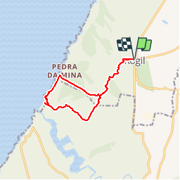
Randonnée Marche de 13,3 km à découvrir à Algarve, Faro. Cette randonnée est proposée par rigol05.
Description
Sortie du 18/05/2018 Départ Rogil. Bel itinéraire en suivant le canal d'irrigation en A/R puis la boucle du circuit de la plage d'Amoreira.Parcours pour observer la flore très variées à cet endroit
Localisation
Pays :
Portugal
Région :
Algarve
Département/Province :
Faro
Commune :
Rogil
Localité :
Unknown
Départ:(Dec)
Départ:(UTM)
517645 ; 4135855 (29S) N.
Commentaires
Randonnées à proximité
![Randonnée Marche Aljezur - w-portugal-kustwandeling-ten-westen-van-aljezur - Photo](https://media.geolcdn.com/t/375/260/ext.jpg?maxdim=2&url=https%3A%2F%2Fstatic1.geolcdn.com%2Fsiteimages%2Fupload%2Ffiles%2F1553511878bg_sport_marche.png)
![Marche Marche](https://static1.geolcdn.com/sitytour/trail-icons/101.png)
w-portugal-kustwandeling-ten-westen-van-aljezur
Marche
Très facile
Aljezur,
Algarve,
Faro,
Portugal
![](/images/other/stat-length.png)
3,6 km | 4,5 km-effort
Inconnu
![](https://static1.geolcdn.com/siteimages/upload/files/16400158638029165_repeat_loop_refresh_sync_direction_icon.png)
Non
![Randonnée Marche Aljezur - B - Praia da Amoreira - 7 Km - Photo](https://media.geolcdn.com/t/375/260/ext.jpg?maxdim=2&url=https%3A%2F%2Fstatic1.geolcdn.com%2Fsiteimages%2Fupload%2Ffiles%2F1553511878bg_sport_marche.png)
![Marche Marche](https://static1.geolcdn.com/sitytour/trail-icons/101.png)
B - Praia da Amoreira - 7 Km
Marche
Facile
Aljezur,
Algarve,
Faro,
Portugal
![](/images/other/stat-length.png)
7,2 km | 8,6 km-effort
1h 51min
![](https://static1.geolcdn.com/siteimages/upload/files/16400158638029165_repeat_loop_refresh_sync_direction_icon.png)
Oui
![Randonnée Marche - w-portugal-rondwandeling-esteveira - Photo](https://media.geolcdn.com/t/375/260/ext.jpg?maxdim=2&url=https%3A%2F%2Fstatic1.geolcdn.com%2Fsiteimages%2Fupload%2Ffiles%2F1553511878bg_sport_marche.png)
![Marche Marche](https://static1.geolcdn.com/sitytour/trail-icons/101.png)
w-portugal-rondwandeling-esteveira
Marche
Très facile
,
Algarve,
Faro,
Portugal
![](/images/other/stat-length.png)
2,1 km | 2,8 km-effort
Inconnu
![](https://static1.geolcdn.com/siteimages/upload/files/16400158638029165_repeat_loop_refresh_sync_direction_icon.png)
Oui
Lots of sandy trail in the middle but otherwise very nice