![](/images/other/stat-length.png)
![Randonnée Vélo Termonde - Stoomspoorlijnroute - Photo](https://media.geolcdn.com/t/1900/400/ext.pjpeg?maxdim=2&url=https%3A%2F%2Fstatic1.geolcdn.com%2Fsiteimages%2Fupload%2Ffiles%2F1524743154velo.jpg)
Stoomspoorlijnroute
KristofDM
Utilisateur
![Longueur](/images/other/stat-length.png)
![Altitude max](https://static1.geolcdn.com/siteimages/upload/files/1508320355ic_sort_altitude_max_24dp.png)
![Dénivelé positif](https://static1.geolcdn.com/siteimages/upload/files/1508320355ic_sort_den_pos_24dp.png)
![Km-Effort](/images/other/stat-length.png)
![Altitude min](https://static1.geolcdn.com/siteimages/upload/files/1508320355ic_sort_altitude_min_24dp.png)
![Dénivelé négatif](https://static1.geolcdn.com/siteimages/upload/files/1508320355ic_sort_den_neg_24dp.png)
![Boucle](https://static1.geolcdn.com/siteimages/upload/files/16400158638029165_repeat_loop_refresh_sync_direction_icon.png)
![Vélo](https://static1.geolcdn.com/sitytour/trail-icons/200.png)
1h06
Difficulté : Facile
![Scannez ce code QR pour ouvrir la randonnée dans l'application SityTrail](https://capi.geolives.com/qq0zvz2zws4bq2lad0pu/sitytour/trails/965167/qr.png?size=200)
Application GPS de randonnée GRATUITE
À propos
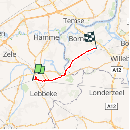
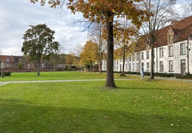
Randonnée Vélo de 17,7 km à découvrir à Flandre, Flandre orientale, Termonde. Cette randonnée est proposée par KristofDM.
Description
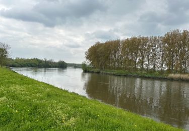
Rijdt met je stalen ros bijna letterlijk in het spoor van de stoomtrein die tussen Baasrode Noord en Puurs rijdt. De bedoeling van deze fietsroute is om zoveel mogelijk het spoor te volgen. Hier en daar moet er echter een afwijking gemaakt worden als er geen baantjes naast het spoor loop.
Meer info over de stoomtrein (alsook wanneer je deze op je rit misschien eens kan tegenkomen) vind je op http://www.stoomtrein.be/nl
Localisation
Commentaires
Randonnées à proximité
![Randonnée A pied Alost - Vossewegel - Photo](https://media.geolcdn.com/t/375/260/790266d6-c757-441e-a4a8-3a2681fe97be.jpeg&format=jpg&maxdim=2)
![A pied A pied](https://static1.geolcdn.com/sitytour/trail-icons/100.png)
A pied
![](/images/other/stat-length.png)
![](https://static1.geolcdn.com/siteimages/upload/files/16400158638029165_repeat_loop_refresh_sync_direction_icon.png)
![Randonnée A pied Zele - Scheldemeersenpad - Photo](https://media.geolcdn.com/t/375/260/fbe7db51-af25-40aa-a60c-86b309dacd4b.jpeg&format=jpg&maxdim=2)
![A pied A pied](https://static1.geolcdn.com/sitytour/trail-icons/100.png)
A pied
![](/images/other/stat-length.png)
![](https://static1.geolcdn.com/siteimages/upload/files/16400158638029165_repeat_loop_refresh_sync_direction_icon.png)
![Randonnée A pied Lebbeke - Rondom Belle - Photo](https://media.geolcdn.com/t/375/260/1bd45d74-f7a9-408b-b213-f19979941bb6.jpeg&format=jpg&maxdim=2)
![A pied A pied](https://static1.geolcdn.com/sitytour/trail-icons/100.png)
A pied
![](/images/other/stat-length.png)
![](https://static1.geolcdn.com/siteimages/upload/files/16400158638029165_repeat_loop_refresh_sync_direction_icon.png)
![Randonnée A pied Lebbeke - Mennenpad - Photo](https://media.geolcdn.com/t/375/260/9ca09073-979e-439c-9e92-d1334cfb6bb5.jpeg&format=jpg&maxdim=2)
![A pied A pied](https://static1.geolcdn.com/sitytour/trail-icons/100.png)
A pied
![](/images/other/stat-length.png)
![](https://static1.geolcdn.com/siteimages/upload/files/16400158638029165_repeat_loop_refresh_sync_direction_icon.png)
![Randonnée Marche Termonde - Dendermonde Kastel 17,8 km - Photo](https://media.geolcdn.com/t/375/260/5ab66c0e-054a-48f1-ae4b-2ec0036e1db9.jpg&format=jpg&maxdim=2)
![Marche Marche](https://static1.geolcdn.com/sitytour/trail-icons/101.png)
Marche
![](/images/other/stat-length.png)
![](https://static1.geolcdn.com/siteimages/upload/files/16400158638029165_repeat_loop_refresh_sync_direction_icon.png)
![Randonnée Marche Lebbeke - Wieze Vossewegelroute - Photo](https://media.geolcdn.com/t/375/260/4cbd18b9-62c2-4f01-919a-e46986a49074.jpg&format=jpg&maxdim=2)
![Marche Marche](https://static1.geolcdn.com/sitytour/trail-icons/101.png)
Marche
![](/images/other/stat-length.png)
![](https://static1.geolcdn.com/siteimages/upload/files/16400158638029165_repeat_loop_refresh_sync_direction_icon.png)
![Randonnée Marche Termonde - Dendermonde Moerzeke 19,5 km - Photo](https://media.geolcdn.com/t/375/260/3a9ee0db-af98-4d38-a619-86d4471bfcdf.jpg&format=jpg&maxdim=2)
![Marche Marche](https://static1.geolcdn.com/sitytour/trail-icons/101.png)
Marche
![](/images/other/stat-length.png)
![](https://static1.geolcdn.com/siteimages/upload/files/16400158638029165_repeat_loop_refresh_sync_direction_icon.png)
![Randonnée Marche Termonde - Dendermonde 18,4 km - Photo](https://media.geolcdn.com/t/375/260/3ce27867-45e6-4e9a-a59f-7c9b466ef5ca.jpg&format=jpg&maxdim=2)
![Marche Marche](https://static1.geolcdn.com/sitytour/trail-icons/101.png)
Marche
![](/images/other/stat-length.png)
![](https://static1.geolcdn.com/siteimages/upload/files/16400158638029165_repeat_loop_refresh_sync_direction_icon.png)
![Randonnée Marche Hamme - Kastel 15,5 km - Photo](https://media.geolcdn.com/t/375/260/ed45e82f-d5d6-4538-a4b3-b0742203189b.jpg&format=jpg&maxdim=2)
![Marche Marche](https://static1.geolcdn.com/sitytour/trail-icons/101.png)
Marche
![](/images/other/stat-length.png)
![](https://static1.geolcdn.com/siteimages/upload/files/16400158638029165_repeat_loop_refresh_sync_direction_icon.png)