![](/images/other/stat-length.png)
![Randonnée Cheval Vigneux-de-Bretagne - boucle 13km vers Vigneux - Photo](https://media.geolcdn.com/t/1900/400/ext.pjpeg?maxdim=2&url=https%3A%2F%2Fstatic1.geolcdn.com%2Fsiteimages%2Fupload%2Ffiles%2F1524743154cheval.jpg)
boucle 13km vers Vigneux
Sevie44
Utilisateur
![Longueur](/images/other/stat-length.png)
Longueur
12,9 km
![Altitude max](https://static1.geolcdn.com/siteimages/upload/files/1508320355ic_sort_altitude_max_24dp.png)
Altitude max
79 m
![Dénivelé positif](https://static1.geolcdn.com/siteimages/upload/files/1508320355ic_sort_den_pos_24dp.png)
Dénivelé positif
163 m
![Km-Effort](/images/other/stat-length.png)
Km-Effort
15,1 km
![Altitude min](https://static1.geolcdn.com/siteimages/upload/files/1508320355ic_sort_altitude_min_24dp.png)
Altitude min
36 m
![Dénivelé négatif](https://static1.geolcdn.com/siteimages/upload/files/1508320355ic_sort_den_neg_24dp.png)
Dénivelé négatif
165 m
![Boucle](https://static1.geolcdn.com/siteimages/upload/files/16400158638029165_repeat_loop_refresh_sync_direction_icon.png)
Boucle
Non
Date de création :
2018-06-26 13:42:08.727
Dernière modification :
2018-06-26 13:42:08.727
![Cheval](https://static1.geolcdn.com/sitytour/trail-icons/300.png)
1h59
Difficulté : Moyen
![Scannez ce code QR pour ouvrir la randonnée dans l'application SityTrail](https://capi.geolives.com/qq0zvz2zws4bq2lad0pu/sitytour/trails/963680/qr.png?size=200)
Application GPS de randonnée GRATUITE
À propos
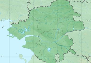
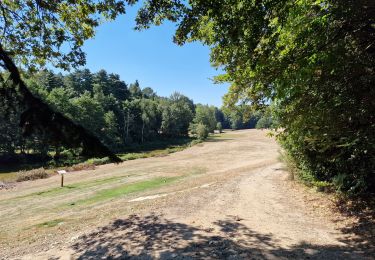
Randonnée Cheval de 12,9 km à découvrir à Pays de la Loire, Loire-Atlantique, Vigneux-de-Bretagne. Cette randonnée est proposée par Sevie44.
Description
plutôt technique sur des passages étroits avec plusieurs ponts dont 2 assez hauts sans garde corps. plusieurs morceaux sans balisage
Localisation
Pays :
France
Région :
Pays de la Loire
Département/Province :
Loire-Atlantique
Commune :
Vigneux-de-Bretagne
Localité :
Unknown
Départ:(Dec)
Départ:(UTM)
599697 ; 5242132 (30T) N.
Commentaires
Randonnées à proximité
![Randonnée A pied Vigneux-de-Bretagne - Le pic vert - Photo](https://media.geolcdn.com/t/375/260/e485ad9f-6a4a-4b57-b44f-601646119e4d.jpeg&format=jpg&maxdim=2)
![A pied A pied](https://static1.geolcdn.com/sitytour/trail-icons/100.png)
Le pic vert
A pied
Facile
Vigneux-de-Bretagne,
Pays de la Loire,
Loire-Atlantique,
France
![](/images/other/stat-length.png)
12,2 km | 13,3 km-effort
3h 1min
![](https://static1.geolcdn.com/siteimages/upload/files/16400158638029165_repeat_loop_refresh_sync_direction_icon.png)
Oui
![Randonnée A pied Treillières - La Vallée du Gesvres - Photo](https://media.geolcdn.com/t/375/260/8559773a-c69a-4cdf-aa57-f4164f184ec9.jpeg&format=jpg&maxdim=2)
![A pied A pied](https://static1.geolcdn.com/sitytour/trail-icons/100.png)
La Vallée du Gesvres
A pied
Facile
Treillières,
Pays de la Loire,
Loire-Atlantique,
France
![](/images/other/stat-length.png)
8,7 km | 10,1 km-effort
2h 18min
![](https://static1.geolcdn.com/siteimages/upload/files/16400158638029165_repeat_loop_refresh_sync_direction_icon.png)
Non
![Randonnée Marche Vigneux-de-Bretagne - De Vigneux de Bretagne à Le Temple de Bretagne - Photo](https://media.geolcdn.com/t/375/260/cb8c8c9d-7e83-4f79-bbaf-b9d8468d333c.jpg&format=jpg&maxdim=2)
![Marche Marche](https://static1.geolcdn.com/sitytour/trail-icons/101.png)
De Vigneux de Bretagne à Le Temple de Bretagne
Marche
Très difficile
Vigneux-de-Bretagne,
Pays de la Loire,
Loire-Atlantique,
France
![](/images/other/stat-length.png)
30 km | 35 km-effort
26h 14min
![](https://static1.geolcdn.com/siteimages/upload/files/16400158638029165_repeat_loop_refresh_sync_direction_icon.png)
Non
![Randonnée A pied Notre-Dame-des-Landes - La chauve-souris - Photo](https://media.geolcdn.com/t/375/260/cf2847e8-63ef-484b-bdeb-a30aa23defd2.jpeg&format=jpg&maxdim=2)
![A pied A pied](https://static1.geolcdn.com/sitytour/trail-icons/100.png)
La chauve-souris
A pied
Facile
Notre-Dame-des-Landes,
Pays de la Loire,
Loire-Atlantique,
France
![](/images/other/stat-length.png)
9 km | 9,7 km-effort
2h 12min
![](https://static1.geolcdn.com/siteimages/upload/files/16400158638029165_repeat_loop_refresh_sync_direction_icon.png)
Oui
![Randonnée Marche Vigneux-de-Bretagne - la Paquelais - Photo](https://media.geolcdn.com/t/375/260/ext.jpg?maxdim=2&url=https%3A%2F%2Fstatic1.geolcdn.com%2Fsiteimages%2Fupload%2Ffiles%2F1553511878bg_sport_marche.png)
![Marche Marche](https://static1.geolcdn.com/sitytour/trail-icons/101.png)
la Paquelais
Marche
Facile
(1)
Vigneux-de-Bretagne,
Pays de la Loire,
Loire-Atlantique,
France
![](/images/other/stat-length.png)
15,4 km | 17,6 km-effort
3h 50min
![](https://static1.geolcdn.com/siteimages/upload/files/16400158638029165_repeat_loop_refresh_sync_direction_icon.png)
Oui
![Randonnée Vélo Sautron - sautron-noirmoutier - Photo](https://media.geolcdn.com/t/375/260/ext.jpg?maxdim=2&url=https%3A%2F%2Fservices.sitytrail.com%2FGeolivesWS%2FDownloadMedia.ashx%3FTrailID%3D152148%26Media%3D20120907135102.jpeg)
![Vélo Vélo](https://static1.geolcdn.com/sitytour/trail-icons/200.png)
sautron-noirmoutier
Vélo
Moyen
Sautron,
Pays de la Loire,
Loire-Atlantique,
France
![](/images/other/stat-length.png)
82 km | 87 km-effort
4h 49min
![](https://static1.geolcdn.com/siteimages/upload/files/16400158638029165_repeat_loop_refresh_sync_direction_icon.png)
Non
![Randonnée Vélo Sautron - sautron-noirmoutier - Photo](https://media.geolcdn.com/t/375/260/ext.jpg?maxdim=2&url=https%3A%2F%2Fservices.sitytrail.com%2FGeolivesWS%2FDownloadMedia.ashx%3FTrailID%3D152147%26Media%3D20120907135102.jpeg)
![Vélo Vélo](https://static1.geolcdn.com/sitytour/trail-icons/200.png)
sautron-noirmoutier
Vélo
Moyen
Sautron,
Pays de la Loire,
Loire-Atlantique,
France
![](/images/other/stat-length.png)
82 km | 87 km-effort
4h 48min
![](https://static1.geolcdn.com/siteimages/upload/files/16400158638029165_repeat_loop_refresh_sync_direction_icon.png)
Non
![Randonnée Marche Treillières - 2010-08-03 - 16h42m56 - Photo](https://media.geolcdn.com/t/375/260/ext.jpg?maxdim=2&url=https%3A%2F%2Fservices.sitytrail.com%2FGeolivesWS%2FDownloadMedia.ashx%3FTrailID%3D42883%26Media%3Dimage3.jpg)
![Marche Marche](https://static1.geolcdn.com/sitytour/trail-icons/101.png)
2010-08-03 - 16h42m56
Marche
Très facile
Treillières,
Pays de la Loire,
Loire-Atlantique,
France
![](/images/other/stat-length.png)
745 km | 1181 km-effort
Inconnu
![](https://static1.geolcdn.com/siteimages/upload/files/16400158638029165_repeat_loop_refresh_sync_direction_icon.png)
Non
![Randonnée Marche Vigneux-de-Bretagne - de Vigneux de Bretagne à Saint Étienne de Montluc - Photo](https://media.geolcdn.com/t/375/260/ae9dc19f-b297-4671-ae8f-96d088e87fd9.jpg&format=jpg&maxdim=2)
![Marche Marche](https://static1.geolcdn.com/sitytour/trail-icons/101.png)
de Vigneux de Bretagne à Saint Étienne de Montluc
Marche
Difficile
Vigneux-de-Bretagne,
Pays de la Loire,
Loire-Atlantique,
France
![](/images/other/stat-length.png)
15,7 km | 17,8 km-effort
3h 25min
![](https://static1.geolcdn.com/siteimages/upload/files/16400158638029165_repeat_loop_refresh_sync_direction_icon.png)
Non