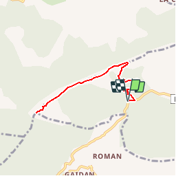
![](/images/other/stat-length.png)
![Randonnée Marche Saint-Geniez - Sisteron: Montagne de Gache - Photo](https://media.geolcdn.com/t/1900/400/ext.pjpeg?maxdim=2&url=https%3A%2F%2Fstatic1.geolcdn.com%2Fsiteimages%2Fupload%2Ffiles%2F1553511878bg_sport_marche.png)
Sisteron: Montagne de Gache
lviallet
Utilisateur
![Longueur](/images/other/stat-length.png)
![Altitude max](https://static1.geolcdn.com/siteimages/upload/files/1508320355ic_sort_altitude_max_24dp.png)
![Dénivelé positif](https://static1.geolcdn.com/siteimages/upload/files/1508320355ic_sort_den_pos_24dp.png)
![Km-Effort](/images/other/stat-length.png)
![Altitude min](https://static1.geolcdn.com/siteimages/upload/files/1508320355ic_sort_altitude_min_24dp.png)
![Dénivelé négatif](https://static1.geolcdn.com/siteimages/upload/files/1508320355ic_sort_den_neg_24dp.png)
![Boucle](https://static1.geolcdn.com/siteimages/upload/files/16400158638029165_repeat_loop_refresh_sync_direction_icon.png)
![Marche](https://static1.geolcdn.com/sitytour/trail-icons/101.png)
3h05
Difficulté : Inconnu
![Scannez ce code QR pour ouvrir la randonnée dans l'application SityTrail](https://capi.geolives.com/qq0zvz2zws4bq2lad0pu/sitytour/trails/961401/qr.png?size=200)
Application GPS de randonnée GRATUITE
À propos
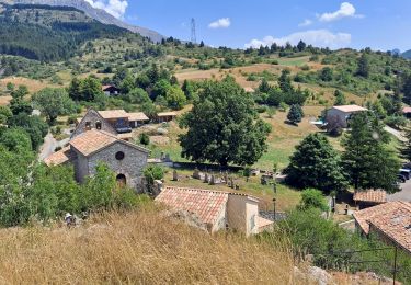
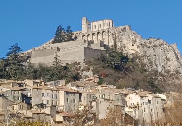
Randonnée Marche de 7,9 km à découvrir à Provence-Alpes-Côte d'Azur, Alpes-de-Haute-Provence, Saint-Geniez. Cette randonnée est proposée par lviallet.
Description
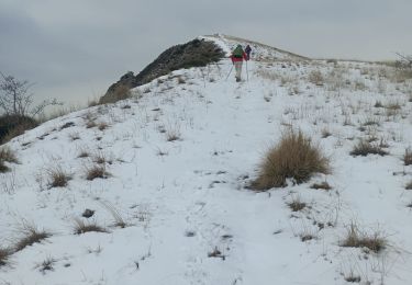
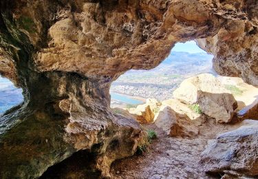
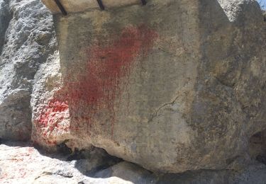
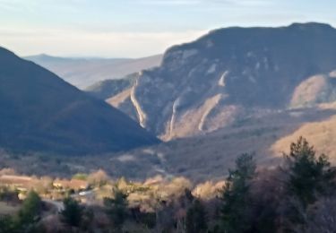
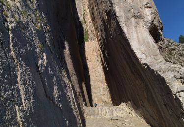
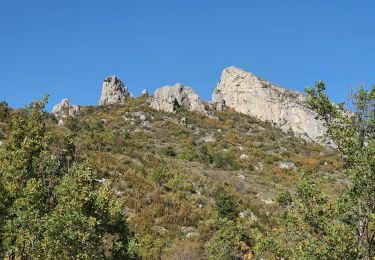
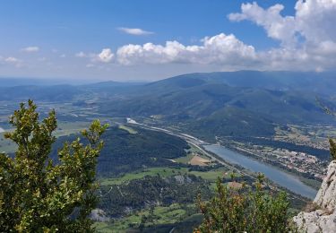
Visorando: Cette impressionnante crête rocheuse est visible depuis Sisteron et ses alentours. Si vous rêvez d'y grimper, voici l'un des itinéraires possibles. Une randonnée assez simple mais qui jouit d'une vue exceptionnelle sur les montagnes, la vallée du Sasse et de la Durance
Localisation
Commentaires
Randonnées à proximité
![Randonnée Marche Saint-Geniez - Le Trainon - Photo](https://media.geolcdn.com/t/375/260/6384f902-eeea-4c31-bc21-4fe490321a44.jpg&format=jpg&maxdim=2)
![Marche Marche](https://static1.geolcdn.com/sitytour/trail-icons/101.png)
Marche
![](/images/other/stat-length.png)
![](https://static1.geolcdn.com/siteimages/upload/files/16400158638029165_repeat_loop_refresh_sync_direction_icon.png)
![Randonnée Marche Sisteron - Le Trou de l'Argent Via Sisteron - Photo](https://media.geolcdn.com/t/375/260/bfa6b4fb-8efb-4bbe-ae9d-f38ed475646a.jpg&format=jpg&maxdim=2)
![Marche Marche](https://static1.geolcdn.com/sitytour/trail-icons/101.png)
Marche
![](/images/other/stat-length.png)
![](https://static1.geolcdn.com/siteimages/upload/files/16400158638029165_repeat_loop_refresh_sync_direction_icon.png)
![Randonnée Marche Valavoire - Sommet de Jouère - Photo](https://media.geolcdn.com/t/375/260/d8443deb-7a4b-44b3-ac6b-fcb5789c326f.jpg&format=jpg&maxdim=2)
![Marche Marche](https://static1.geolcdn.com/sitytour/trail-icons/101.png)
Marche
![](/images/other/stat-length.png)
![](https://static1.geolcdn.com/siteimages/upload/files/16400158638029165_repeat_loop_refresh_sync_direction_icon.png)
![Randonnée Marche Saint-Geniez - Pierre écrite et montagne de Gache - Photo](https://media.geolcdn.com/t/375/260/7a1ca822-6c04-425e-94b9-5be1080d03a0.jpg&format=jpg&maxdim=2)
![Marche Marche](https://static1.geolcdn.com/sitytour/trail-icons/101.png)
Marche
![](/images/other/stat-length.png)
![](https://static1.geolcdn.com/siteimages/upload/files/16400158638029165_repeat_loop_refresh_sync_direction_icon.png)
![Randonnée Marche Entrepierres - SAINT GENIEZ . LE MOURRE DE GACHE PAR LA FONT DE MEGE N - Photo](https://media.geolcdn.com/t/375/260/5d853fdd-5713-4858-a535-57b1bf5db08d.jpg&format=jpg&maxdim=2)
![Marche Marche](https://static1.geolcdn.com/sitytour/trail-icons/101.png)
Marche
![](/images/other/stat-length.png)
![](https://static1.geolcdn.com/siteimages/upload/files/16400158638029165_repeat_loop_refresh_sync_direction_icon.png)
![Randonnée Marche Sisteron - 05 trop argent 02.08.23 - Photo](https://media.geolcdn.com/t/375/260/2f52f635-2a11-4916-a9f5-f3227f3b1529.jpg&format=jpg&maxdim=2)
![Marche Marche](https://static1.geolcdn.com/sitytour/trail-icons/101.png)
Marche
![](/images/other/stat-length.png)
![](https://static1.geolcdn.com/siteimages/upload/files/16400158638029165_repeat_loop_refresh_sync_direction_icon.png)
![Randonnée Marche Sisteron - SISTERON. SUR LA ROUTE DU TEMPS 2. O L M S - Photo](https://media.geolcdn.com/t/375/260/20c8aa54-ba97-4a73-8287-049a48bb92a8.jpg&format=jpg&maxdim=2)
![Marche Marche](https://static1.geolcdn.com/sitytour/trail-icons/101.png)
Marche
![](/images/other/stat-length.png)
![](https://static1.geolcdn.com/siteimages/upload/files/16400158638029165_repeat_loop_refresh_sync_direction_icon.png)
![Randonnée Marche Saint-Geniez - 28-10-2022 Tour du Dromon - Photo](https://media.geolcdn.com/t/375/260/143c8162-2f8c-416a-a5c9-32f364c7a4e0.jpg&format=jpg&maxdim=2)
![Marche Marche](https://static1.geolcdn.com/sitytour/trail-icons/101.png)
Marche
![](/images/other/stat-length.png)
![](https://static1.geolcdn.com/siteimages/upload/files/16400158638029165_repeat_loop_refresh_sync_direction_icon.png)
![Randonnée Marche Sisteron - Trou de l'argent - Photo](https://media.geolcdn.com/t/375/260/efd53f67-e8d5-4c71-be71-21c3c1bbbb50.jpg&format=jpg&maxdim=2)
![Marche Marche](https://static1.geolcdn.com/sitytour/trail-icons/101.png)
Marche
![](/images/other/stat-length.png)
![](https://static1.geolcdn.com/siteimages/upload/files/16400158638029165_repeat_loop_refresh_sync_direction_icon.png)