Randonnée Marche Châtelus - pas de l'allier  - Photo
 guyzinz
guyzinz

Utilisateur

© OpenStreetMap contributors
Longueur
Longueur
17,5 km
Altitude max
Altitude max
1279 m
Dénivelé positif
Dénivelé positif
1152 m
Km-Effort
Km-Effort  
33 km
Altitude min
Altitude min
306 m
Dénivelé négatif
Dénivelé négatif
1170 m
Boucle
Boucle
Oui
Date de création :
2019-06-07 09:39:03.65
Dernière modification :
2019-06-07 09:39:03.97

(0 Avis)

Marche
Marche
6h54
Difficulté : Inconnu

Scannez ce code QR pour ouvrir la randonnée dans l'application SityTrail

Application GPS de randonnée GRATUITE

Logo SityTrail SityTrail

IGN / Instituts géographiques

Télécharger SityTrail sur l'App Store Télécharger SityTrail sur Google Play

Logo SityTrail SityTrail World

Le monde est à vous

Télécharger SityTrail sur l'App Store Télécharger SityTrail sur Google Play Télécharger SityTrail sur Huawei AppGallery

À propos

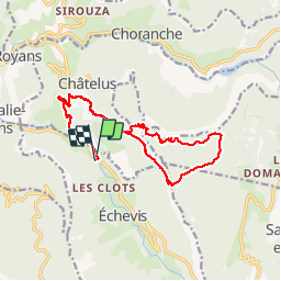
Randonnée Marche de 17,5 km à découvrir à Auvergne-Rhône-Alpes, Isère, Châtelus. Cette randonnée est proposée par guyzinz.

Description

depart "pont d'echevis" montée vers mezelier pas des voutes rochers du bournillon pas de l'allier retour sur pont d'echevis en passant par mezelier

Profil altimétrique

Localisation

Pays :
France
Région :
Auvergne-Rhône-Alpes
Département/Province :
Isère
Commune :
Châtelus
Localité :
Unknown
Départ:(Dec)
Départ:(UTM)
687161 ; 4990169 (31T) N.

Randonnées à proximité

Randonnée Marche Châtelus - 38 bournillon porte du diable charmatte - Photo
Marche
GUIDE
randodyssée

Marche

Difficile
(1)
Châtelus, Auvergne-Rhône-Alpes, Isère, France
16,5 km | 34 km-effort
8h 7min
Oui
Randonnée Marche La Chapelle-en-Vercors - Belvedere de la Révoulat - Photo
Marche
simon.paume

Marche

Facile
(1)
La Chapelle-en-Vercors, Auvergne-Rhône-Alpes, Drôme, France
5,3 km | 10,6 km-effort
2h 5min
Oui
Randonnée Marche Châtelus - Boucle Pas de l'Allier - Pas des Voutes - Photo
Marche
tracegps

Marche

Moyen
(1)
Châtelus, Auvergne-Rhône-Alpes, Isère, France
10,1 km | 22 km-effort
4h 30min
Oui
Randonnée Marche Saint-Laurent-en-Royans - 26 rocher des mines ARP - Photo
Marche
GUIDE
randodyssée

Marche

Très difficile
Saint-Laurent-en-Royans, Auvergne-Rhône-Alpes, Drôme, France
8,6 km | 16,2 km-effort
6h 53min
Oui
Randonnée Marche Sainte-Eulalie-en-Royans - 26 ste eulalie - Photo
Marche
GUIDE
randodyssée

Marche

Moyen
Sainte-Eulalie-en-Royans, Auvergne-Rhône-Alpes, Drôme, France
14,8 km | 27 km-effort
6h 43min
Non
Randonnée Marche Châtelus - 38 pabro charmatte - Photo
Marche
GUIDE
randodyssée

Marche

Difficile
Châtelus, Auvergne-Rhône-Alpes, Isère, France
11,4 km | 29 km-effort
7h 43min
Oui
Randonnée Marche Pont-en-Royans - 38 pont en Royans choranche presles - Photo
Marche
GUIDE
randodyssée

Marche

Difficile
Pont-en-Royans, Auvergne-Rhône-Alpes, Isère, France
15,4 km | 30 km-effort
6h 52min
Oui
Randonnée Marche Pont-en-Royans - 38 pont en Royans st andre - Photo
Marche
GUIDE
randodyssée

Marche

Facile
Pont-en-Royans, Auvergne-Rhône-Alpes, Isère, France
14,1 km | 19,3 km-effort
3h 33min
Oui
Randonnée Marche Pont-en-Royans - 38 pont en Royans serre cocu - Photo
Marche
GUIDE
randodyssée

Marche

Moyen
Pont-en-Royans, Auvergne-Rhône-Alpes, Isère, France
16 km | 29 km-effort
7h 44min
Oui


Fermer
Mes abonnements