Randonnée Autre activité Thérondels - Therondels à Pierrefort - Photo

Therondels à Pierrefort

 paul12
paul12

Utilisateur

© OpenStreetMap contributors
Longueur
Longueur
12,3 km
Altitude max
Altitude max
994 m
Dénivelé positif
Dénivelé positif
391 m
Km-Effort
Km-Effort  
17,6 km
Altitude min
Altitude min
673 m
Dénivelé négatif
Dénivelé négatif
414 m
Boucle
Boucle
Non
Date de création :
2018-06-26 13:14:51.689
Dernière modification :
2018-06-26 13:14:51.689

(0 Avis)

Autre activité
Autre activité
4h21
Difficulté : Moyen

Scannez ce code QR pour ouvrir la randonnée dans l'application SityTrail

Application GPS de randonnée GRATUITE

Logo SityTrail SityTrail

IGN / Instituts géographiques

Télécharger SityTrail sur l'App Store Télécharger SityTrail sur Google Play

Logo SityTrail SityTrail World

Le monde est à vous

Télécharger SityTrail sur l'App Store Télécharger SityTrail sur Google Play Télécharger SityTrail sur Huawei AppGallery

À propos

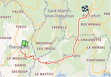
Randonnée Autre activité de 12,3 km à découvrir à Occitanie, Aveyron, Thérondels. Cette randonnée est proposée par paul12.

Description

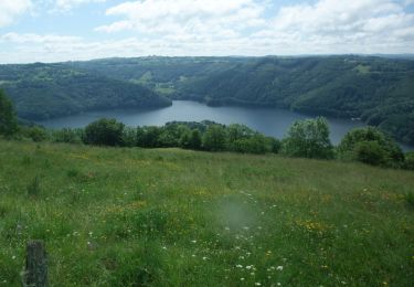
Un départ à 950 m le passage du pont d estradié à 650 m environ.un parcours en chemin creux ou piste agricole avec une belle flore des haies et avec un peu de chance la vue d un chevreuil.

Profil altimétrique

Localisation

Pays :
France
Région :
Occitanie
Département/Province :
Aveyron
Commune :
Thérondels
Localité :
Unknown
Départ:(Dec)
Départ:(UTM)
481077 ; 4971181 (31T) N.

Randonnées à proximité

Randonnée Marche Thérondels - Thérondels,Nigresserre - Photo
Marche
paul12

Marche

Facile
(1)
Thérondels, Occitanie, Aveyron, France
12,7 km | 14,8 km-effort
3h 14min
Non
Randonnée Marche Thérondels - Balade à la presqu''ile de Laussac - Thérondels - Photo
Marche
tracegps

Marche

Difficile
(1)
Thérondels, Occitanie, Aveyron, France
17,1 km | 24 km-effort
6h 0min
Oui
Randonnée Marche Lacapelle-Barrès - puy de Bane - Photo
Marche
Jean-Marie Bousquet

Marche

Difficile
Lacapelle-Barrès, Auvergne-Rhône-Alpes, Cantal, France
19,2 km | 26 km-effort
4h 3min
Oui
Randonnée Marche Thérondels - Therondels  - Photo
Marche
bougnaou

Marche

Moyen
Thérondels, Occitanie, Aveyron, France
15,9 km | 22 km-effort
3h 14min
Oui
Randonnée Marche Paulhenc - tersons 13b - Photo
Marche
catherineslater

Marche

Très facile
Paulhenc, Auvergne-Rhône-Alpes, Cantal, France
11,4 km | 13,7 km-effort
3h 9min
Non
Randonnée Marche Thérondels - THÉRONDELS _ et le paysan créa la prairie 2) - Photo
Marche
Elbe

Marche

Très facile
(1)
Thérondels, Occitanie, Aveyron, France
4,1 km | 4,8 km-effort
1h 30min
Oui
Randonnée Marche Thérondels - Sentier imaginaire court Therondels  - Photo
Marche
Danielfontange

Marche

Facile
Thérondels, Occitanie, Aveyron, France
3,6 km | 3,9 km-effort
1h 11min
Oui
Randonnée Marche Cantoin - Vines les berges du lac de Sarrans - Photo
Marche
les joyeux randonneurs

Marche

Difficile
(1)
Cantoin, Occitanie, Aveyron, France
11,2 km | 16,4 km-effort
3h 43min
Oui
Randonnée Vélo électrique Saint-Martin-sous-Vigouroux - 6_280423 - Photo
Vélo électrique
ricou1964

Vélo électrique

Difficile
Saint-Martin-sous-Vigouroux, Auvergne-Rhône-Alpes, Cantal, France
71 km | 90 km-effort
10h 6min
Non


Fermer
Mes abonnements