![](/images/other/stat-length.png)
![Randonnée Marche Voreppe - Le tour du vallon de Malsouche - Photo](https://media.geolcdn.com/t/1900/400/ext.pjpeg?maxdim=2&url=https%3A%2F%2Fservices.sitytrail.com%2FGeolivesWS%2FDownloadMedia.ashx%3FTrailID%3D952163%26Media%3Dfix__20180426134138.jpg)
Le tour du vallon de Malsouche
patjobou
Utilisateur
![Longueur](/images/other/stat-length.png)
Longueur
17,3 km
![Altitude max](https://static1.geolcdn.com/siteimages/upload/files/1508320355ic_sort_altitude_max_24dp.png)
Altitude max
1076 m
![Dénivelé positif](https://static1.geolcdn.com/siteimages/upload/files/1508320355ic_sort_den_pos_24dp.png)
Dénivelé positif
1127 m
![Km-Effort](/images/other/stat-length.png)
Km-Effort
32 km
![Altitude min](https://static1.geolcdn.com/siteimages/upload/files/1508320355ic_sort_altitude_min_24dp.png)
Altitude min
255 m
![Dénivelé négatif](https://static1.geolcdn.com/siteimages/upload/files/1508320355ic_sort_den_neg_24dp.png)
Dénivelé négatif
1129 m
![Boucle](https://static1.geolcdn.com/siteimages/upload/files/16400158638029165_repeat_loop_refresh_sync_direction_icon.png)
Boucle
Oui
Date de création :
2018-06-26 12:32:53.716
Dernière modification :
2018-06-26 12:32:53.716
![Marche](https://static1.geolcdn.com/sitytour/trail-icons/101.png)
6h36
Difficulté : Moyen
![Scannez ce code QR pour ouvrir la randonnée dans l'application SityTrail](https://capi.geolives.com/qq0zvz2zws4bq2lad0pu/sitytour/trails/952163/qr.png?size=200)
Application GPS de randonnée GRATUITE
À propos
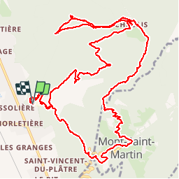
Randonnée Marche de 17,3 km à découvrir à Auvergne-Rhône-Alpes, Isère, Voreppe. Cette randonnée est proposée par patjobou.
Description
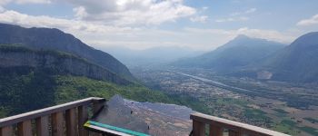
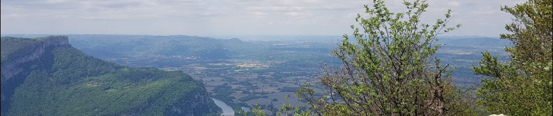
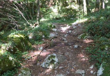
Boucle: Le Chevalon de Voreppe - La cheminée de Mont St Martin - Le couvent et l'aiguille de Chalais. La cheminée de Mont St martin est bien équipée et sécurisée. (Avril 208).
Les dénivellés sont peut être un peu sur estimés: Plutot D =1000m.
Localisation
Pays :
France
Région :
Auvergne-Rhône-Alpes
Département/Province :
Isère
Commune :
Voreppe
Localité :
Unknown
Départ:(Dec)
Départ:(UTM)
707961 ; 5017341 (31T) N.
Commentaires
Randonnées à proximité
![Randonnée Marche Voreppe - Le Rocher de Lorzier, 1838m - Photo](https://media.geolcdn.com/t/375/260/ext.jpg?maxdim=2&url=https%3A%2F%2Fservices.sitytrail.com%2FGeolivesWS%2FDownloadMedia.ashx%3FTrailID%3D105680%26Media%3D9506_1.jpg)
![Marche Marche](https://static1.geolcdn.com/sitytour/trail-icons/101.png)
Le Rocher de Lorzier, 1838m
Marche
Moyen
(2)
Voreppe,
Auvergne-Rhône-Alpes,
Isère,
France
![](/images/other/stat-length.png)
12,3 km | 25 km-effort
4h 45min
![](https://static1.geolcdn.com/siteimages/upload/files/16400158638029165_repeat_loop_refresh_sync_direction_icon.png)
Oui
![Randonnée Marche Voreppe - 38 voreppe - Photo](https://media.geolcdn.com/t/375/260/ae534631-eaae-45ff-8bde-8ca8e28aadbe.jpg&format=jpg&maxdim=2)
![Marche Marche](https://static1.geolcdn.com/sitytour/trail-icons/101.png)
38 voreppe
Marche
Moyen
Voreppe,
Auvergne-Rhône-Alpes,
Isère,
France
![](/images/other/stat-length.png)
8,7 km | 16,8 km-effort
6h 25min
![](https://static1.geolcdn.com/siteimages/upload/files/16400158638029165_repeat_loop_refresh_sync_direction_icon.png)
Oui
![Randonnée Marche Voreppe - chalet des bannette par la cheminée et le pas de l'âne - Photo](https://media.geolcdn.com/t/375/260/1e724d55-35f1-431a-a226-5d4d8430026f.jpg&format=jpg&maxdim=2)
![Marche Marche](https://static1.geolcdn.com/sitytour/trail-icons/101.png)
chalet des bannette par la cheminée et le pas de l'âne
Marche
Moyen
Voreppe,
Auvergne-Rhône-Alpes,
Isère,
France
![](/images/other/stat-length.png)
12,4 km | 25 km-effort
5h 25min
![](https://static1.geolcdn.com/siteimages/upload/files/16400158638029165_repeat_loop_refresh_sync_direction_icon.png)
Oui
![Randonnée Marche Voreppe - 38 la roize - Photo](https://media.geolcdn.com/t/375/260/aa413979-8680-4ab9-a3c8-d00868a6c4b7.jpg&format=jpg&maxdim=2)
![Marche Marche](https://static1.geolcdn.com/sitytour/trail-icons/101.png)
38 la roize
Marche
Difficile
Voreppe,
Auvergne-Rhône-Alpes,
Isère,
France
![](/images/other/stat-length.png)
5,8 km | 10,5 km-effort
3h 17min
![](https://static1.geolcdn.com/siteimages/upload/files/16400158638029165_repeat_loop_refresh_sync_direction_icon.png)
Oui
![Randonnée Vélo électrique Voreppe - voreppe saint julien le grand raz voreppe - Photo](https://media.geolcdn.com/t/375/260/ext.jpg?maxdim=2&url=https%3A%2F%2Fstatic1.geolcdn.com%2Fsiteimages%2Fupload%2Ffiles%2F1524743154velo.jpg)
![Vélo électrique Vélo électrique](https://static1.geolcdn.com/sitytour/trail-icons/205.png)
voreppe saint julien le grand raz voreppe
Vélo électrique
Difficile
(1)
Voreppe,
Auvergne-Rhône-Alpes,
Isère,
France
![](/images/other/stat-length.png)
35 km | 50 km-effort
Inconnu
![](https://static1.geolcdn.com/siteimages/upload/files/16400158638029165_repeat_loop_refresh_sync_direction_icon.png)
Oui
![Randonnée Marche Voreppe - Rocher de Lorzier - Photo](https://media.geolcdn.com/t/375/260/44d1aac1-481d-4e20-af4b-16c5baf65295.jpg&format=jpg&maxdim=2)
![Marche Marche](https://static1.geolcdn.com/sitytour/trail-icons/101.png)
Rocher de Lorzier
Marche
Moyen
Voreppe,
Auvergne-Rhône-Alpes,
Isère,
France
![](/images/other/stat-length.png)
12,8 km | 26 km-effort
5h 11min
![](https://static1.geolcdn.com/siteimages/upload/files/16400158638029165_repeat_loop_refresh_sync_direction_icon.png)
Oui
![Randonnée Marche Proveysieux - le rocher de l'Eglise en traversee - Photo](https://media.geolcdn.com/t/375/260/ext.jpg?maxdim=2&url=https%3A%2F%2Fstatic1.geolcdn.com%2Fsiteimages%2Fupload%2Ffiles%2F1553511878bg_sport_marche.png)
![Marche Marche](https://static1.geolcdn.com/sitytour/trail-icons/101.png)
le rocher de l'Eglise en traversee
Marche
Difficile
(1)
Proveysieux,
Auvergne-Rhône-Alpes,
Isère,
France
![](/images/other/stat-length.png)
10,5 km | 22 km-effort
8h 16min
![](https://static1.geolcdn.com/siteimages/upload/files/16400158638029165_repeat_loop_refresh_sync_direction_icon.png)
Oui
![Randonnée Marche La Sure en Chartreuse - 38 passieres charminelle zel 01.08.24 - Photo](https://media.geolcdn.com/t/375/260/9de42ebf-df5c-4604-8183-1923a1af8070.jpg&format=jpg&maxdim=2)
![Marche Marche](https://static1.geolcdn.com/sitytour/trail-icons/101.png)
38 passieres charminelle zel 01.08.24
Marche
Difficile
La Sure en Chartreuse,
Auvergne-Rhône-Alpes,
Isère,
France
![](/images/other/stat-length.png)
12,2 km | 23 km-effort
7h 14min
![](https://static1.geolcdn.com/siteimages/upload/files/16400158638029165_repeat_loop_refresh_sync_direction_icon.png)
Oui
![Randonnée Marche Voreppe - le trou au loup - Photo](https://media.geolcdn.com/t/375/260/4be90cdf-26f4-4d2a-b22f-02f0baa87490.jpg&format=jpg&maxdim=2)
![Marche Marche](https://static1.geolcdn.com/sitytour/trail-icons/101.png)
le trou au loup
Marche
Difficile
Voreppe,
Auvergne-Rhône-Alpes,
Isère,
France
![](/images/other/stat-length.png)
8,5 km | 16,5 km-effort
6h 29min
![](https://static1.geolcdn.com/siteimages/upload/files/16400158638029165_repeat_loop_refresh_sync_direction_icon.png)
Oui