![](/images/other/stat-length.png)
![Randonnée Marche Saint-André-d'Embrun - Balcon de la Durance. Lac de Siguret. (22-04-18) - Photo](https://media.geolcdn.com/t/1900/400/ext.pjpeg?maxdim=2&url=https%3A%2F%2Fservices.sitytrail.com%2FGeolivesWS%2FDownloadMedia.ashx%3FTrailID%3D948985%26Media%3Dfix__20180422162109.jpg)
Balcon de la Durance. Lac de Siguret. (22-04-18)
Dervalmarc
Utilisateur
![Longueur](/images/other/stat-length.png)
Longueur
2,6 km
![Altitude max](https://static1.geolcdn.com/siteimages/upload/files/1508320355ic_sort_altitude_max_24dp.png)
Altitude max
1124 m
![Dénivelé positif](https://static1.geolcdn.com/siteimages/upload/files/1508320355ic_sort_den_pos_24dp.png)
Dénivelé positif
58 m
![Km-Effort](/images/other/stat-length.png)
Km-Effort
3,3 km
![Altitude min](https://static1.geolcdn.com/siteimages/upload/files/1508320355ic_sort_altitude_min_24dp.png)
Altitude min
1063 m
![Dénivelé négatif](https://static1.geolcdn.com/siteimages/upload/files/1508320355ic_sort_den_neg_24dp.png)
Dénivelé négatif
57 m
![Boucle](https://static1.geolcdn.com/siteimages/upload/files/16400158638029165_repeat_loop_refresh_sync_direction_icon.png)
Boucle
Oui
Date de création :
2018-06-26 10:58:47.831
Dernière modification :
2018-06-26 10:58:47.831
![Marche](https://static1.geolcdn.com/sitytour/trail-icons/101.png)
40m
Difficulté : Facile
![Scannez ce code QR pour ouvrir la randonnée dans l'application SityTrail](https://capi.geolives.com/qq0zvz2zws4bq2lad0pu/sitytour/trails/948985/qr.png?size=200)
Application GPS de randonnée GRATUITE
À propos
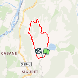
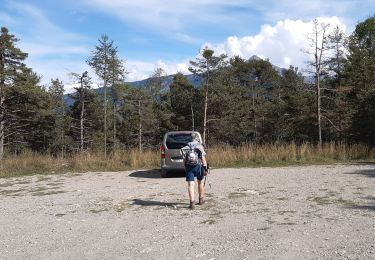
Randonnée Marche de 2,6 km à découvrir à Provence-Alpes-Côte d'Azur, Hautes-Alpes, Saint-André-d'Embrun. Cette randonnée est proposée par Dervalmarc.
Description
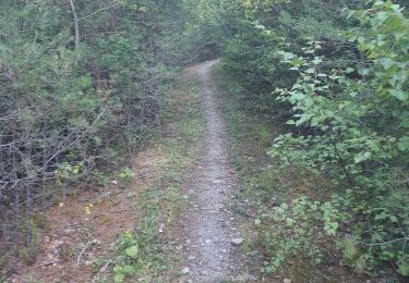
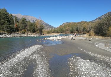
Petite randonnée agréable en balcon sur la Durance.
Nombreux points de vue sur la vallée du Rabioux.
Attention au vide avec des enfants.
Localisation
Pays :
France
Région :
Provence-Alpes-Côte d'Azur
Département/Province :
Hautes-Alpes
Commune :
Saint-André-d'Embrun
Localité :
Unknown
Départ:(Dec)
Départ:(UTM)
305924 ; 4942744 (32T) N.
Commentaires
Randonnées à proximité
![Randonnée Marche Saint-André-d'Embrun - mont Aurel - Photo](https://media.geolcdn.com/t/375/260/43268f02-4aa7-403a-bf4c-3a2f3a5ea0ea.jpg&format=jpg&maxdim=2)
![Marche Marche](https://static1.geolcdn.com/sitytour/trail-icons/101.png)
mont Aurel
Marche
Moyen
(1)
Saint-André-d'Embrun,
Provence-Alpes-Côte d'Azur,
Hautes-Alpes,
France
![](/images/other/stat-length.png)
8,2 km | 18,4 km-effort
4h 30min
![](https://static1.geolcdn.com/siteimages/upload/files/16400158638029165_repeat_loop_refresh_sync_direction_icon.png)
Oui
![Randonnée Marche Châteauroux-les-Alpes - Cascade de la pisse (boucle) - Photo](https://media.geolcdn.com/t/375/260/ext.jpg?maxdim=2&url=https%3A%2F%2Fservices.sitytrail.com%2FGeolivesWS%2FDownloadMedia.ashx%3FTrailID%3D455276%26Media%3Dfix__20150806173304.jpg)
![Marche Marche](https://static1.geolcdn.com/sitytour/trail-icons/101.png)
Cascade de la pisse (boucle)
Marche
Très facile
(1)
Châteauroux-les-Alpes,
Provence-Alpes-Côte d'Azur,
Hautes-Alpes,
France
![](/images/other/stat-length.png)
8,8 km | 12,4 km-effort
2h 17min
![](https://static1.geolcdn.com/siteimages/upload/files/16400158638029165_repeat_loop_refresh_sync_direction_icon.png)
Oui
![Randonnée Marche Saint-André-d'Embrun - chalet de la biche . mont orel . chapelle de pra leydon . chalet de la coche - Photo](https://media.geolcdn.com/t/375/260/fc8a76ce-7e92-44f8-a3b6-e3a752334a37.jpg&format=jpg&maxdim=2)
![Marche Marche](https://static1.geolcdn.com/sitytour/trail-icons/101.png)
chalet de la biche . mont orel . chapelle de pra leydon . chalet de la coche
Marche
Difficile
Saint-André-d'Embrun,
Provence-Alpes-Côte d'Azur,
Hautes-Alpes,
France
![](/images/other/stat-length.png)
9,4 km | 21 km-effort
4h 59min
![](https://static1.geolcdn.com/siteimages/upload/files/16400158638029165_repeat_loop_refresh_sync_direction_icon.png)
Non
![Randonnée Raquettes à neige Châteauroux-les-Alpes - EMBRUN JOUR 1 : Vallon du Rabioux - Cascade de la Pisse - Photo](https://media.geolcdn.com/t/375/260/d9396b19-b145-421d-9a18-40870191a398.jpg&format=jpg&maxdim=2)
![Raquettes à neige Raquettes à neige](https://static1.geolcdn.com/sitytour/trail-icons/504.png)
EMBRUN JOUR 1 : Vallon du Rabioux - Cascade de la Pisse
Raquettes à neige
Moyen
Châteauroux-les-Alpes,
Provence-Alpes-Côte d'Azur,
Hautes-Alpes,
France
![](/images/other/stat-length.png)
11,6 km | 17,4 km-effort
4h 14min
![](https://static1.geolcdn.com/siteimages/upload/files/16400158638029165_repeat_loop_refresh_sync_direction_icon.png)
Oui
![Randonnée Marche Saint-André-d'Embrun - rikiki rando du lac Siguret - Photo](https://media.geolcdn.com/t/375/260/52f40784-8d21-496b-ad2b-0069d16e739b.jpg&format=jpg&maxdim=2)
![Marche Marche](https://static1.geolcdn.com/sitytour/trail-icons/101.png)
rikiki rando du lac Siguret
Marche
Très facile
Saint-André-d'Embrun,
Provence-Alpes-Côte d'Azur,
Hautes-Alpes,
France
![](/images/other/stat-length.png)
3,3 km | 4,2 km-effort
58min
![](https://static1.geolcdn.com/siteimages/upload/files/16400158638029165_repeat_loop_refresh_sync_direction_icon.png)
Oui
![Randonnée Marche Saint-André-d'Embrun - Chapelle de Pra-Leydon - Les Croix à partir du vallon de Pra-Mouton - Photo](https://media.geolcdn.com/t/375/260/aacec509-0b58-4c91-85a8-3755e48f0d89.jpg&format=jpg&maxdim=2)
![Marche Marche](https://static1.geolcdn.com/sitytour/trail-icons/101.png)
Chapelle de Pra-Leydon - Les Croix à partir du vallon de Pra-Mouton
Marche
Très difficile
Saint-André-d'Embrun,
Provence-Alpes-Côte d'Azur,
Hautes-Alpes,
France
![](/images/other/stat-length.png)
6,8 km | 15,3 km-effort
3h 45min
![](https://static1.geolcdn.com/siteimages/upload/files/16400158638029165_repeat_loop_refresh_sync_direction_icon.png)
Oui
![Randonnée Marche Saint-André-d'Embrun - Boucle lac de Siguret et Chapelle Saint Roch - Photo](https://media.geolcdn.com/t/375/260/fbc2a18a-e642-4c0d-b75a-60178da3586c.jpg&format=jpg&maxdim=2)
![Marche Marche](https://static1.geolcdn.com/sitytour/trail-icons/101.png)
Boucle lac de Siguret et Chapelle Saint Roch
Marche
Moyen
Saint-André-d'Embrun,
Provence-Alpes-Côte d'Azur,
Hautes-Alpes,
France
![](/images/other/stat-length.png)
6,7 km | 9,6 km-effort
2h 14min
![](https://static1.geolcdn.com/siteimages/upload/files/16400158638029165_repeat_loop_refresh_sync_direction_icon.png)
Oui
![Randonnée Marche Saint-André-d'Embrun - pinée et vietnam 221021 - Photo](https://media.geolcdn.com/t/375/260/27c3cea1-ec64-47ac-a5f6-028a06cafd44.jpg&format=jpg&maxdim=2)
![Marche Marche](https://static1.geolcdn.com/sitytour/trail-icons/101.png)
pinée et vietnam 221021
Marche
Très facile
Saint-André-d'Embrun,
Provence-Alpes-Côte d'Azur,
Hautes-Alpes,
France
![](/images/other/stat-length.png)
39 km | 50 km-effort
4h 23min
![](https://static1.geolcdn.com/siteimages/upload/files/16400158638029165_repeat_loop_refresh_sync_direction_icon.png)
Non
![Randonnée Marche Châteauroux-les-Alpes - la cascade de la Pisse - Photo](https://media.geolcdn.com/t/375/260/fb47a976-7b88-4f5d-b9a4-7570b5e8b3ed.jpg&format=jpg&maxdim=2)
![Marche Marche](https://static1.geolcdn.com/sitytour/trail-icons/101.png)
la cascade de la Pisse
Marche
Moyen
Châteauroux-les-Alpes,
Provence-Alpes-Côte d'Azur,
Hautes-Alpes,
France
![](/images/other/stat-length.png)
11,1 km | 15,9 km-effort
4h 26min
![](https://static1.geolcdn.com/siteimages/upload/files/16400158638029165_repeat_loop_refresh_sync_direction_icon.png)
Oui