![](/images/other/stat-length.png)
![Randonnée V.T.T. Belley - Boucle des craz - Photo](https://media.geolcdn.com/t/1900/400/ext.pjpeg?maxdim=2&url=https%3A%2F%2Fstatic1.geolcdn.com%2Fsiteimages%2Fupload%2Ffiles%2F1524743154velo.jpg)
Boucle des craz
jeannot01
Utilisateur
![Longueur](/images/other/stat-length.png)
Longueur
27 km
![Altitude max](https://static1.geolcdn.com/siteimages/upload/files/1508320355ic_sort_altitude_max_24dp.png)
Altitude max
421 m
![Dénivelé positif](https://static1.geolcdn.com/siteimages/upload/files/1508320355ic_sort_den_pos_24dp.png)
Dénivelé positif
508 m
![Km-Effort](/images/other/stat-length.png)
Km-Effort
33 km
![Altitude min](https://static1.geolcdn.com/siteimages/upload/files/1508320355ic_sort_altitude_min_24dp.png)
Altitude min
227 m
![Dénivelé négatif](https://static1.geolcdn.com/siteimages/upload/files/1508320355ic_sort_den_neg_24dp.png)
Dénivelé négatif
507 m
![Boucle](https://static1.geolcdn.com/siteimages/upload/files/16400158638029165_repeat_loop_refresh_sync_direction_icon.png)
Boucle
Oui
Date de création :
2018-04-25 20:28:20.908
Dernière modification :
2018-04-25 20:28:20.908
![V.T.T.](https://static1.geolcdn.com/sitytour/trail-icons/202.png)
2h09
Difficulté : Moyen
![Scannez ce code QR pour ouvrir la randonnée dans l'application SityTrail](https://capi.geolives.com/qq0zvz2zws4bq2lad0pu/sitytour/trails/947106/qr.png?size=200)
Application GPS de randonnée GRATUITE
À propos
Randonnée V.T.T. de 27 km à découvrir à Auvergne-Rhône-Alpes, Ain, Belley. Cette randonnée est proposée par jeannot01.
Description
Un bel enchainement des craz avec dugros chemin pour les montées et du single pour les descentes.
Pas de difficulté particulière
Au 1er PT1, bien prendre à gauche le single pour faire la craz des buis.
Localisation
Pays :
France
Région :
Auvergne-Rhône-Alpes
Département/Province :
Ain
Commune :
Belley
Localité :
Unknown
Départ:(Dec)
Départ:(UTM)
708595 ; 5069626 (31T) N.
Commentaires
Randonnées à proximité
![V.T.T. V.T.T.](https://static1.geolcdn.com/sitytour/trail-icons/202.png)
Inimond depuis Belley par le chemin forestier
V.T.T.
Difficile
(1)
Belley,
Auvergne-Rhône-Alpes,
Ain,
France
![](/images/other/stat-length.png)
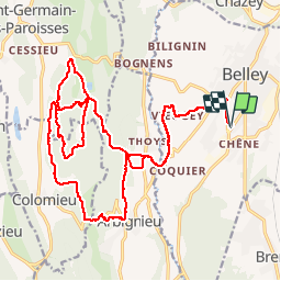
39 km | 54 km-effort
3h 0min
![](https://static1.geolcdn.com/siteimages/upload/files/16400158638029165_repeat_loop_refresh_sync_direction_icon.png)
Oui
![Randonnée V.T.T. Belley - 29-04 - Photo](https://media.geolcdn.com/t/375/260/ext.jpg?maxdim=2&url=https%3A%2F%2Fservices.sitytrail.com%2FGeolivesWS%2FDownloadMedia.ashx%3FTrailID%3D414275%26Media%3Dfix__20150429194314.jpg)
![V.T.T. V.T.T.](https://static1.geolcdn.com/sitytour/trail-icons/202.png)
29-04
V.T.T.
Difficile
(1)
Belley,
Auvergne-Rhône-Alpes,
Ain,
France
![](/images/other/stat-length.png)
35 km | 46 km-effort
3h 0min
![](https://static1.geolcdn.com/siteimages/upload/files/16400158638029165_repeat_loop_refresh_sync_direction_icon.png)
Oui
![Randonnée V.T.T. Pollieu - Entre lac et rivière - Photo](https://media.geolcdn.com/t/375/260/ext.jpg?maxdim=2&url=https%3A%2F%2Fstatic1.geolcdn.com%2Fsiteimages%2Fupload%2Ffiles%2F1524743154velo.jpg)
![V.T.T. V.T.T.](https://static1.geolcdn.com/sitytour/trail-icons/202.png)
Entre lac et rivière
V.T.T.
Difficile
(1)
Pollieu,
Auvergne-Rhône-Alpes,
Ain,
France
![](/images/other/stat-length.png)
30 km | 36 km-effort
2h 13min
![](https://static1.geolcdn.com/siteimages/upload/files/16400158638029165_repeat_loop_refresh_sync_direction_icon.png)
Oui
![Randonnée V.T.T. Belley - Entre Belley et Vognes en passant par le lac de ST Champs - Photo](https://media.geolcdn.com/t/375/260/ext.jpg?maxdim=2&url=https%3A%2F%2Fstatic1.geolcdn.com%2Fsiteimages%2Fupload%2Ffiles%2F1524743154velo.jpg)
![V.T.T. V.T.T.](https://static1.geolcdn.com/sitytour/trail-icons/202.png)
Entre Belley et Vognes en passant par le lac de ST Champs
V.T.T.
Très facile
(1)
Belley,
Auvergne-Rhône-Alpes,
Ain,
France
![](/images/other/stat-length.png)
25 km | 32 km-effort
2h 28min
![](https://static1.geolcdn.com/siteimages/upload/files/16400158638029165_repeat_loop_refresh_sync_direction_icon.png)
Oui
![Randonnée V.T.T. Belley - Belley-Colomieu-Appregnin - Photo](https://media.geolcdn.com/t/375/260/ext.jpg?maxdim=2&url=https%3A%2F%2Fstatic1.geolcdn.com%2Fsiteimages%2Fupload%2Ffiles%2F1524743154velo.jpg)
![V.T.T. V.T.T.](https://static1.geolcdn.com/sitytour/trail-icons/202.png)
Belley-Colomieu-Appregnin
V.T.T.
Difficile
(1)
Belley,
Auvergne-Rhône-Alpes,
Ain,
France
![](/images/other/stat-length.png)
32 km | 41 km-effort
2h 32min
![](https://static1.geolcdn.com/siteimages/upload/files/16400158638029165_repeat_loop_refresh_sync_direction_icon.png)
Oui
![Randonnée V.T.T. Belley - Boucles dans Rothones sous la pluie - Photo](https://media.geolcdn.com/t/375/260/ext.jpg?maxdim=2&url=https%3A%2F%2Fstatic1.geolcdn.com%2Fsiteimages%2Fupload%2Ffiles%2F1524743154velo.jpg)
![V.T.T. V.T.T.](https://static1.geolcdn.com/sitytour/trail-icons/202.png)
Boucles dans Rothones sous la pluie
V.T.T.
Moyen
(1)
Belley,
Auvergne-Rhône-Alpes,
Ain,
France
![](/images/other/stat-length.png)
24 km | 32 km-effort
1h 50min
![](https://static1.geolcdn.com/siteimages/upload/files/16400158638029165_repeat_loop_refresh_sync_direction_icon.png)
Oui
![Randonnée V.T.T. Saint-Germain-les-Paroisses - 6-5-15 - Photo](https://media.geolcdn.com/t/375/260/ext.jpg?maxdim=2&url=https%3A%2F%2Fstatic1.geolcdn.com%2Fsiteimages%2Fupload%2Ffiles%2F1524743154velo.jpg)
![V.T.T. V.T.T.](https://static1.geolcdn.com/sitytour/trail-icons/202.png)
6-5-15
V.T.T.
Très facile
(1)
Saint-Germain-les-Paroisses,
Auvergne-Rhône-Alpes,
Ain,
France
![](/images/other/stat-length.png)
25 km | 37 km-effort
2h 57min
![](https://static1.geolcdn.com/siteimages/upload/files/16400158638029165_repeat_loop_refresh_sync_direction_icon.png)
Oui
![Randonnée V.T.T. Belley - 03-9-14 - Photo](https://media.geolcdn.com/t/375/260/ext.jpg?maxdim=2&url=https%3A%2F%2Fstatic1.geolcdn.com%2Fsiteimages%2Fupload%2Ffiles%2F1524743154velo.jpg)
![V.T.T. V.T.T.](https://static1.geolcdn.com/sitytour/trail-icons/202.png)
03-9-14
V.T.T.
Très facile
(1)
Belley,
Auvergne-Rhône-Alpes,
Ain,
France
![](/images/other/stat-length.png)
32 km | 42 km-effort
2h 32min
![](https://static1.geolcdn.com/siteimages/upload/files/16400158638029165_repeat_loop_refresh_sync_direction_icon.png)
Oui
![Randonnée V.T.T. Belley - 9-4-14 - Photo](https://media.geolcdn.com/t/375/260/ext.jpg?maxdim=2&url=https%3A%2F%2Fstatic1.geolcdn.com%2Fsiteimages%2Fupload%2Ffiles%2F1524743154velo.jpg)
![V.T.T. V.T.T.](https://static1.geolcdn.com/sitytour/trail-icons/202.png)