![](/images/other/stat-length.png)
![Randonnée Marche Stavelot - WATER TREK - le Parcours des Vallées - 6. COO - TARGNON - Photo](https://media.geolcdn.com/t/1900/400/ext.pjpeg?maxdim=2&url=https%3A%2F%2Fstatic1.geolcdn.com%2Fsiteimages%2Fupload%2Ffiles%2F1553511878bg_sport_marche.png)
WATER TREK - le Parcours des Vallées - 6. COO - TARGNON
aqualis
Utilisateur
![Longueur](/images/other/stat-length.png)
Longueur
16,6 km
![Altitude max](https://static1.geolcdn.com/siteimages/upload/files/1508320355ic_sort_altitude_max_24dp.png)
Altitude max
457 m
![Dénivelé positif](https://static1.geolcdn.com/siteimages/upload/files/1508320355ic_sort_den_pos_24dp.png)
Dénivelé positif
526 m
![Km-Effort](/images/other/stat-length.png)
Km-Effort
24 km
![Altitude min](https://static1.geolcdn.com/siteimages/upload/files/1508320355ic_sort_altitude_min_24dp.png)
Altitude min
206 m
![Dénivelé négatif](https://static1.geolcdn.com/siteimages/upload/files/1508320355ic_sort_den_neg_24dp.png)
Dénivelé négatif
544 m
![Boucle](https://static1.geolcdn.com/siteimages/upload/files/16400158638029165_repeat_loop_refresh_sync_direction_icon.png)
Boucle
Non
Date de création :
2019-06-13 12:17:51.841
Dernière modification :
2019-06-13 12:17:52.258
![Marche](https://static1.geolcdn.com/sitytour/trail-icons/101.png)
4h49
Difficulté : Moyen
![Scannez ce code QR pour ouvrir la randonnée dans l'application SityTrail](https://capi.geolives.com/qq0zvz2zws4bq2lad0pu/sitytour/trails/946632/qr.png?size=200)
Application GPS de randonnée GRATUITE
À propos
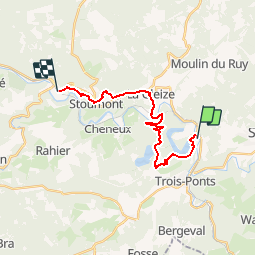
Randonnée Marche de 16,6 km à découvrir à Wallonie, Liège, Stavelot. Cette randonnée est proposée par aqualis.
Description
Après Coo, sa cascade et ses lacs, il faut parvenir à la vallée de l'Amblève en gravissant la colline de Brume. Mais quels paysages vous allez découvrir! Grandiose. Avant de rejoindre la Gleize et ses souvenirs de la bataille des Ardennes
Points d'intérêt
Localisation
Pays :
Belgique
Région :
Wallonie
Département/Province :
Liège
Commune :
Stavelot
Localité :
Stavelot
Départ:(Dec)
Départ:(UTM)
704623 ; 5586090 (31U) N.
Commentaires
Randonnées à proximité
![Randonnée Marche Trois-Ponts - RB-Lg-29_Wanne - Photo](https://media.geolcdn.com/t/375/260/ext.jpg?maxdim=2&url=https%3A%2F%2Fservices.sitytrail.com%2FGeolivesWS%2FDownloadMedia.ashx%3FTrailID%3D402097%26Media%3Dd4589c74-2522-4a62-866b-b5d0038bf075.jpg)
![Marche Marche](https://static1.geolcdn.com/sitytour/trail-icons/101.png)
![Randonnée Marche Trois-Ponts - RB-Lg-27_Trois-Ponts - Photo](https://media.geolcdn.com/t/375/260/ext.jpg?maxdim=2&url=https%3A%2F%2Fservices.sitytrail.com%2FGeolivesWS%2FDownloadMedia.ashx%3FTrailID%3D402090%26Media%3Ddb9e80d9-8efc-4045-abb6-cee4f6885ea2.jpg)
![Marche Marche](https://static1.geolcdn.com/sitytour/trail-icons/101.png)
RB-Lg-27_Trois-Ponts
Marche
(7)
Trois-Ponts,
Wallonie,
Liège,
Belgique
![](/images/other/stat-length.png)
23 km | 33 km-effort
7h 30min
![](https://static1.geolcdn.com/siteimages/upload/files/16400158638029165_repeat_loop_refresh_sync_direction_icon.png)
Oui
![Randonnée Marche Stoumont - RB-Lg-13_Stoumont - Photo](https://media.geolcdn.com/t/375/260/ext.jpg?maxdim=2&url=https%3A%2F%2Fservices.sitytrail.com%2FGeolivesWS%2FDownloadMedia.ashx%3FTrailID%3D179571%26Media%3Dfca3b0ca-06fe-45d6-8ded-857ea27270cf.jpg)
![Marche Marche](https://static1.geolcdn.com/sitytour/trail-icons/101.png)
RB-Lg-13_Stoumont
Marche
Très difficile
(11)
Stoumont,
Wallonie,
Liège,
Belgique
![](/images/other/stat-length.png)
23 km | 32 km-effort
7h 19min
![](https://static1.geolcdn.com/siteimages/upload/files/16400158638029165_repeat_loop_refresh_sync_direction_icon.png)
Oui
![Randonnée Marche Stavelot - Extratrail_stavelot_13km_new - Photo](https://media.geolcdn.com/t/375/260/acb4a21b-3ac7-4958-9a44-c1358ae78040.jpg&format=jpg&maxdim=2)
![Marche Marche](https://static1.geolcdn.com/sitytour/trail-icons/101.png)
Extratrail_stavelot_13km_new
Marche
Moyen
(2)
Stavelot,
Wallonie,
Liège,
Belgique
![](/images/other/stat-length.png)
13,4 km | 19,8 km-effort
4h 30min
![](https://static1.geolcdn.com/siteimages/upload/files/16400158638029165_repeat_loop_refresh_sync_direction_icon.png)
Oui
![Randonnée Marche Stoumont - La Gleize - P3 - Tour du Mont Saint-Victor - Photo](https://media.geolcdn.com/t/375/260/eeda461f-0b98-4912-915c-63b0e2025382.jpg&format=jpg&maxdim=2)
![Marche Marche](https://static1.geolcdn.com/sitytour/trail-icons/101.png)
La Gleize - P3 - Tour du Mont Saint-Victor
Marche
Moyen
(3)
Stoumont,
Wallonie,
Liège,
Belgique
![](/images/other/stat-length.png)
15,8 km | 22 km-effort
5h 2min
![](https://static1.geolcdn.com/siteimages/upload/files/16400158638029165_repeat_loop_refresh_sync_direction_icon.png)
Oui
![Randonnée Marche Stavelot - Stavelot - Photo](https://media.geolcdn.com/t/375/260/8b34c446-55a9-478c-88d7-9cb986b390fb.jpg&format=jpg&maxdim=2)
![Marche Marche](https://static1.geolcdn.com/sitytour/trail-icons/101.png)
Stavelot
Marche
Difficile
(3)
Stavelot,
Wallonie,
Liège,
Belgique
![](/images/other/stat-length.png)
18,8 km | 26 km-effort
5h 53min
![](https://static1.geolcdn.com/siteimages/upload/files/16400158638029165_repeat_loop_refresh_sync_direction_icon.png)
Non
![Randonnée Marche Trois-Ponts - RB-Lg-27_Trois-Ponts_via-racc - Photo](https://media.geolcdn.com/t/375/260/ext.jpg?maxdim=2&url=https%3A%2F%2Fservices.sitytrail.com%2FGeolivesWS%2FDownloadMedia.ashx%3FTrailID%3D402091%26Media%3Ddb9e80d9-8efc-4045-abb6-cee4f6885ea2.jpg)
![Marche Marche](https://static1.geolcdn.com/sitytour/trail-icons/101.png)
RB-Lg-27_Trois-Ponts_via-racc
Marche
Très difficile
(1)
Trois-Ponts,
Wallonie,
Liège,
Belgique
![](/images/other/stat-length.png)
16,9 km | 25 km-effort
5h 36min
![](https://static1.geolcdn.com/siteimages/upload/files/16400158638029165_repeat_loop_refresh_sync_direction_icon.png)
Oui
![Randonnée Marche Stavelot - Chemin des Sources |étape n°3 STAVELOT – HOCKAI - Photo](https://media.geolcdn.com/t/375/260/77791607-24fa-4b91-a259-1d28dbfa8616.jpg&format=jpg&maxdim=2)
![Marche Marche](https://static1.geolcdn.com/sitytour/trail-icons/101.png)
Chemin des Sources |étape n°3 STAVELOT – HOCKAI
Marche
Très difficile
(1)
Stavelot,
Wallonie,
Liège,
Belgique
![](/images/other/stat-length.png)
19 km | 25 km-effort
5h 45min
![](https://static1.geolcdn.com/siteimages/upload/files/16400158638029165_repeat_loop_refresh_sync_direction_icon.png)
Non
![Randonnée Marche Stoumont - RB-Lg-13_Stoumont_via-racc - Photo](https://media.geolcdn.com/t/375/260/ext.jpg?maxdim=2&url=https%3A%2F%2Fservices.sitytrail.com%2FGeolivesWS%2FDownloadMedia.ashx%3FTrailID%3D179572%26Media%3Ddd649bf1-a115-4c1e-9e23-c1a80ab51103.jpg)
![Marche Marche](https://static1.geolcdn.com/sitytour/trail-icons/101.png)
RB-Lg-13_Stoumont_via-racc
Marche
Très difficile
(3)
Stoumont,
Wallonie,
Liège,
Belgique
![](/images/other/stat-length.png)
17,6 km | 24 km-effort
5h 25min
![](https://static1.geolcdn.com/siteimages/upload/files/16400158638029165_repeat_loop_refresh_sync_direction_icon.png)
Oui