![](/images/other/stat-length.png)
![Randonnée Marche Hauterive-la-Fresse - Balade autour de La Combe d'Hauterive 2 - Photo](https://media.geolcdn.com/t/1900/400/ext.pjpeg?maxdim=2&url=https%3A%2F%2Fstatic1.geolcdn.com%2Fsiteimages%2Fupload%2Ffiles%2F1553511878bg_sport_marche.png)
Balade autour de La Combe d'Hauterive 2
micheldutilleul
Utilisateur
![Longueur](/images/other/stat-length.png)
Longueur
7,2 km
![Altitude max](https://static1.geolcdn.com/siteimages/upload/files/1508320355ic_sort_altitude_max_24dp.png)
Altitude max
1076 m
![Dénivelé positif](https://static1.geolcdn.com/siteimages/upload/files/1508320355ic_sort_den_pos_24dp.png)
Dénivelé positif
145 m
![Km-Effort](/images/other/stat-length.png)
Km-Effort
9,1 km
![Altitude min](https://static1.geolcdn.com/siteimages/upload/files/1508320355ic_sort_altitude_min_24dp.png)
Altitude min
969 m
![Dénivelé négatif](https://static1.geolcdn.com/siteimages/upload/files/1508320355ic_sort_den_neg_24dp.png)
Dénivelé négatif
145 m
![Boucle](https://static1.geolcdn.com/siteimages/upload/files/16400158638029165_repeat_loop_refresh_sync_direction_icon.png)
Boucle
Oui
Date de création :
2018-04-18 00:14:27.924
Dernière modification :
2018-04-18 00:14:27.924
![Marche](https://static1.geolcdn.com/sitytour/trail-icons/101.png)
2h15
Difficulté : Moyen
![Scannez ce code QR pour ouvrir la randonnée dans l'application SityTrail](https://capi.geolives.com/qq0zvz2zws4bq2lad0pu/sitytour/trails/940986/qr.png?size=200)
Application GPS de randonnée GRATUITE
À propos
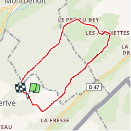
Randonnée Marche de 7,2 km à découvrir à Bourgogne-Franche-Comté, Doubs, Hauterive-la-Fresse. Cette randonnée est proposée par micheldutilleul.
Description
Balade de 2h15 proposée par Karine (la propriétaire de chalets à La Combe d'Hauterive)
Localisation
Pays :
France
Région :
Bourgogne-Franche-Comté
Département/Province :
Doubs
Commune :
Hauterive-la-Fresse
Localité :
Unknown
Départ:(Dec)
Départ:(UTM)
307028 ; 5204911 (32T) N.
Commentaires
Randonnées à proximité
![Randonnée V.T.T. Hauterive-la-Fresse - j4 - Photo](https://media.geolcdn.com/t/375/260/a9ac3dd3-b700-483e-a7b1-dcdda8001723.jpg&format=jpg&maxdim=2)
![V.T.T. V.T.T.](https://static1.geolcdn.com/sitytour/trail-icons/202.png)
j4
V.T.T.
Très difficile
Hauterive-la-Fresse,
Bourgogne-Franche-Comté,
Doubs,
France
![](/images/other/stat-length.png)
64 km | 88 km-effort
5h 11min
![](https://static1.geolcdn.com/siteimages/upload/files/16400158638029165_repeat_loop_refresh_sync_direction_icon.png)
Non
![Randonnée Marche Les Alliés - GTJ Etape 9 : les Alliés - la Cluse et Mijoux - Photo](https://media.geolcdn.com/t/375/260/7c89b720-7548-4f03-b80b-e732eaf938d4.jpg&format=jpg&maxdim=2)
![Marche Marche](https://static1.geolcdn.com/sitytour/trail-icons/101.png)
GTJ Etape 9 : les Alliés - la Cluse et Mijoux
Marche
Moyen
Les Alliés,
Bourgogne-Franche-Comté,
Doubs,
France
![](/images/other/stat-length.png)
19,9 km | 27 km-effort
6h 20min
![](https://static1.geolcdn.com/siteimages/upload/files/16400158638029165_repeat_loop_refresh_sync_direction_icon.png)
Non
![Randonnée Randonnée équestre Pontarlier - vujn - Photo](https://media.geolcdn.com/t/375/260/ext.jpg?maxdim=2&url=https%3A%2F%2Fstatic1.geolcdn.com%2Fsiteimages%2Fupload%2Ffiles%2F1524743154cheval.jpg)
![Randonnée équestre Randonnée équestre](https://static1.geolcdn.com/sitytour/trail-icons/301.png)
vujn
Randonnée équestre
Moyen
Pontarlier,
Bourgogne-Franche-Comté,
Doubs,
France
![](/images/other/stat-length.png)
17,2 km | 23 km-effort
3h 8min
![](https://static1.geolcdn.com/siteimages/upload/files/16400158638029165_repeat_loop_refresh_sync_direction_icon.png)
Non
![Randonnée V.T.T. Hauterive-la-Fresse - hauterive - Photo](https://media.geolcdn.com/t/375/260/ext.jpg?maxdim=2&url=https%3A%2F%2Fstatic1.geolcdn.com%2Fsiteimages%2Fupload%2Ffiles%2F1524743154velo.jpg)
![V.T.T. V.T.T.](https://static1.geolcdn.com/sitytour/trail-icons/202.png)
hauterive
V.T.T.
Moyen
Hauterive-la-Fresse,
Bourgogne-Franche-Comté,
Doubs,
France
![](/images/other/stat-length.png)
18,1 km | 26 km-effort
1h 58min
![](https://static1.geolcdn.com/siteimages/upload/files/16400158638029165_repeat_loop_refresh_sync_direction_icon.png)
Oui
![Randonnée Marche Les Alliés - GTJ jour 7 - Photo](https://media.geolcdn.com/t/375/260/f9803914-4168-45b7-b81d-9be528ad53b4.jpg&format=jpg&maxdim=2)
![Marche Marche](https://static1.geolcdn.com/sitytour/trail-icons/101.png)
GTJ jour 7
Marche
Moyen
Les Alliés,
Bourgogne-Franche-Comté,
Doubs,
France
![](/images/other/stat-length.png)
13,9 km | 19,3 km-effort
4h 20min
![](https://static1.geolcdn.com/siteimages/upload/files/16400158638029165_repeat_loop_refresh_sync_direction_icon.png)
Non
![Randonnée Marche Hauterive-la-Fresse - Balade autour de La Combe d'Hauterive - Photo](https://media.geolcdn.com/t/375/260/ext.jpg?maxdim=2&url=https%3A%2F%2Fstatic1.geolcdn.com%2Fsiteimages%2Fupload%2Ffiles%2F1553511878bg_sport_marche.png)
![Marche Marche](https://static1.geolcdn.com/sitytour/trail-icons/101.png)
Balade autour de La Combe d'Hauterive
Marche
Facile
Hauterive-la-Fresse,
Bourgogne-Franche-Comté,
Doubs,
France
![](/images/other/stat-length.png)
4,1 km | 5,4 km-effort
1h 15min
![](https://static1.geolcdn.com/siteimages/upload/files/16400158638029165_repeat_loop_refresh_sync_direction_icon.png)
Oui
![Randonnée V.T.T. Hauterive-la-Fresse - Morteau - Metabief - Photo](https://media.geolcdn.com/t/375/260/ext.jpg?maxdim=2&url=https%3A%2F%2Fservices.sitytrail.com%2FGeolivesWS%2FDownloadMedia.ashx%3FTrailID%3D362246%26Media%3D20141112132901.jpg)
![V.T.T. V.T.T.](https://static1.geolcdn.com/sitytour/trail-icons/202.png)
Morteau - Metabief
V.T.T.
Difficile
Hauterive-la-Fresse,
Bourgogne-Franche-Comté,
Doubs,
France
![](/images/other/stat-length.png)
39 km | 51 km-effort
4h 25min
![](https://static1.geolcdn.com/siteimages/upload/files/16400158638029165_repeat_loop_refresh_sync_direction_icon.png)
Non
![Randonnée V.T.T. Ville-du-Pont - La Belle d'Entreroche - Ville du Pont - Photo](https://media.geolcdn.com/t/375/260/ext.jpg?maxdim=2&url=https%3A%2F%2Fstatic1.geolcdn.com%2Fsiteimages%2Fupload%2Ffiles%2F1524743154velo.jpg)
![V.T.T. V.T.T.](https://static1.geolcdn.com/sitytour/trail-icons/202.png)
La Belle d'Entreroche - Ville du Pont
V.T.T.
Moyen
Ville-du-Pont,
Bourgogne-Franche-Comté,
Doubs,
France
![](/images/other/stat-length.png)
18,1 km | 23 km-effort
2h 0min
![](https://static1.geolcdn.com/siteimages/upload/files/16400158638029165_repeat_loop_refresh_sync_direction_icon.png)
Oui
![Randonnée Randonnée équestre Pontarlier - obhin - Photo](https://media.geolcdn.com/t/375/260/ext.jpg?maxdim=2&url=https%3A%2F%2Fstatic1.geolcdn.com%2Fsiteimages%2Fupload%2Ffiles%2F1524743154cheval.jpg)
![Randonnée équestre Randonnée équestre](https://static1.geolcdn.com/sitytour/trail-icons/301.png)
obhin
Randonnée équestre
Facile
Pontarlier,
Bourgogne-Franche-Comté,
Doubs,
France
![](/images/other/stat-length.png)
7,9 km | 10,4 km-effort
1h 17min
![](https://static1.geolcdn.com/siteimages/upload/files/16400158638029165_repeat_loop_refresh_sync_direction_icon.png)
Non