![](/images/other/stat-length.png)
![Randonnée V.T.T. Saint-Clément - sortie vtt du 08042018 - Photo](https://media.geolcdn.com/t/1900/400/ext.pjpeg?maxdim=2&url=https%3A%2F%2Fservices.sitytrail.com%2FGeolivesWS%2FDownloadMedia.ashx%3FTrailID%3D938872%26Media%3Dfix__20180408121406.jpg)
sortie vtt du 08042018
fabwin
Utilisateur GUIDE
![Longueur](/images/other/stat-length.png)
Longueur
34 km
![Altitude max](https://static1.geolcdn.com/siteimages/upload/files/1508320355ic_sort_altitude_max_24dp.png)
Altitude max
286 m
![Dénivelé positif](https://static1.geolcdn.com/siteimages/upload/files/1508320355ic_sort_den_pos_24dp.png)
Dénivelé positif
247 m
![Km-Effort](/images/other/stat-length.png)
Km-Effort
37 km
![Altitude min](https://static1.geolcdn.com/siteimages/upload/files/1508320355ic_sort_altitude_min_24dp.png)
Altitude min
222 m
![Dénivelé négatif](https://static1.geolcdn.com/siteimages/upload/files/1508320355ic_sort_den_neg_24dp.png)
Dénivelé négatif
246 m
![Boucle](https://static1.geolcdn.com/siteimages/upload/files/16400158638029165_repeat_loop_refresh_sync_direction_icon.png)
Boucle
Oui
Date de création :
2018-04-17 23:57:12.137
Dernière modification :
2018-04-17 23:57:12.137
![V.T.T.](https://static1.geolcdn.com/sitytour/trail-icons/202.png)
2h27
Difficulté : Facile
![Scannez ce code QR pour ouvrir la randonnée dans l'application SityTrail](https://capi.geolives.com/qq0zvz2zws4bq2lad0pu/sitytour/trails/938872/qr.png?size=200)
Application GPS de randonnée GRATUITE
À propos
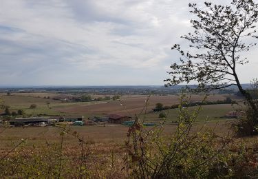
Randonnée V.T.T. de 34 km à découvrir à Grand Est, Meurthe-et-Moselle, Saint-Clément. Cette randonnée est proposée par fabwin.
Description
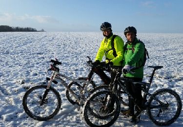
Très belle sortie sous le soleil et un début de chaleur. Avec David, Séb, Jojo et Ange.
Encore un peu boueux par endroit, c'est bon pour la peau parait-il!!!!!
Localisation
Pays :
France
Région :
Grand Est
Département/Province :
Meurthe-et-Moselle
Commune :
Saint-Clément
Localité :
Unknown
Départ:(Dec)
Départ:(UTM)
323005 ; 5378538 (32U) N.
Commentaires
Randonnées à proximité
![Randonnée V.T.T. Saint-Clément - sortie vtt du 06102018 Haut de la Coye - Photo](https://media.geolcdn.com/t/375/260/22209b83-88be-4ec6-96d5-4c24191799ff.jpg&format=jpg&maxdim=2)
![V.T.T. V.T.T.](https://static1.geolcdn.com/sitytour/trail-icons/202.png)
sortie vtt du 06102018 Haut de la Coye
V.T.T.
Moyen
(1)
Saint-Clément,
Grand Est,
Meurthe-et-Moselle,
France
![](/images/other/stat-length.png)
49 km | 54 km-effort
3h 2min
![](https://static1.geolcdn.com/siteimages/upload/files/16400158638029165_repeat_loop_refresh_sync_direction_icon.png)
Oui
![Randonnée V.T.T. Saint-Clément - sortie vtt du17012016 - Photo](https://media.geolcdn.com/t/375/260/ext.jpg?maxdim=2&url=https%3A%2F%2Fservices.sitytrail.com%2FGeolivesWS%2FDownloadMedia.ashx%3FTrailID%3D513627%26Media%3Dfix__20160117100214.jpg)
![V.T.T. V.T.T.](https://static1.geolcdn.com/sitytour/trail-icons/202.png)
sortie vtt du17012016
V.T.T.
Moyen
(1)
Saint-Clément,
Grand Est,
Meurthe-et-Moselle,
France
![](/images/other/stat-length.png)
42 km | 48 km-effort
3h 9min
![](https://static1.geolcdn.com/siteimages/upload/files/16400158638029165_repeat_loop_refresh_sync_direction_icon.png)
Oui
![Randonnée V.T.T. Saint-Clément - sortie vtt du 14082016 - Photo](https://media.geolcdn.com/t/375/260/ext.jpg?maxdim=2&url=https%3A%2F%2Fstatic1.geolcdn.com%2Fsiteimages%2Fupload%2Ffiles%2F1524743154velo.jpg)
![V.T.T. V.T.T.](https://static1.geolcdn.com/sitytour/trail-icons/202.png)
sortie vtt du 14082016
V.T.T.
Moyen
(1)
Saint-Clément,
Grand Est,
Meurthe-et-Moselle,
France
![](/images/other/stat-length.png)
46 km | 53 km-effort
3h 28min
![](https://static1.geolcdn.com/siteimages/upload/files/16400158638029165_repeat_loop_refresh_sync_direction_icon.png)
Oui
![Randonnée V.T.T. Saint-Clément - sortie vtt 08042016 - Photo](https://media.geolcdn.com/t/375/260/ext.jpg?maxdim=2&url=https%3A%2F%2Fstatic1.geolcdn.com%2Fsiteimages%2Fupload%2Ffiles%2F1524743154velo.jpg)
![V.T.T. V.T.T.](https://static1.geolcdn.com/sitytour/trail-icons/202.png)
sortie vtt 08042016
V.T.T.
Moyen
(1)
Saint-Clément,
Grand Est,
Meurthe-et-Moselle,
France
![](/images/other/stat-length.png)
45 km | 51 km-effort
2h 50min
![](https://static1.geolcdn.com/siteimages/upload/files/16400158638029165_repeat_loop_refresh_sync_direction_icon.png)
Oui
![Randonnée V.T.T. Saint-Clément - sortie vtt du 13122015 baccarat badmenil - Photo](https://media.geolcdn.com/t/375/260/ext.jpg?maxdim=2&url=https%3A%2F%2Fstatic1.geolcdn.com%2Fsiteimages%2Fupload%2Ffiles%2F1524743154velo.jpg)
![V.T.T. V.T.T.](https://static1.geolcdn.com/sitytour/trail-icons/202.png)
sortie vtt du 13122015 baccarat badmenil
V.T.T.
Moyen
(1)
Saint-Clément,
Grand Est,
Meurthe-et-Moselle,
France
![](/images/other/stat-length.png)
39 km | 45 km-effort
2h 59min
![](https://static1.geolcdn.com/siteimages/upload/files/16400158638029165_repeat_loop_refresh_sync_direction_icon.png)
Oui
![Randonnée V.T.T. Saint-Clément - sortie vtt du 25102015 - Photo](https://media.geolcdn.com/t/375/260/ext.jpg?maxdim=2&url=https%3A%2F%2Fstatic1.geolcdn.com%2Fsiteimages%2Fupload%2Ffiles%2F1524743154velo.jpg)
![V.T.T. V.T.T.](https://static1.geolcdn.com/sitytour/trail-icons/202.png)
sortie vtt du 25102015
V.T.T.
Moyen
(3)
Saint-Clément,
Grand Est,
Meurthe-et-Moselle,
France
![](/images/other/stat-length.png)
44 km | 50 km-effort
3h 19min
![](https://static1.geolcdn.com/siteimages/upload/files/16400158638029165_repeat_loop_refresh_sync_direction_icon.png)
Oui
![Randonnée V.T.T. Saint-Clément - sortie vtt 18102015 - Photo](https://media.geolcdn.com/t/375/260/ext.jpg?maxdim=2&url=https%3A%2F%2Fstatic1.geolcdn.com%2Fsiteimages%2Fupload%2Ffiles%2F1524743154velo.jpg)
![V.T.T. V.T.T.](https://static1.geolcdn.com/sitytour/trail-icons/202.png)
sortie vtt 18102015
V.T.T.
Moyen
(1)
Saint-Clément,
Grand Est,
Meurthe-et-Moselle,
France
![](/images/other/stat-length.png)
39 km | 43 km-effort
2h 53min
![](https://static1.geolcdn.com/siteimages/upload/files/16400158638029165_repeat_loop_refresh_sync_direction_icon.png)
Oui
![Randonnée V.T.T. Saint-Clément - Sortie vtt du 18102014 - Photo](https://media.geolcdn.com/t/375/260/ext.jpg?maxdim=2&url=https%3A%2F%2Fstatic1.geolcdn.com%2Fsiteimages%2Fupload%2Ffiles%2F1524743154velo.jpg)
![V.T.T. V.T.T.](https://static1.geolcdn.com/sitytour/trail-icons/202.png)
Sortie vtt du 18102014
V.T.T.
Moyen
(1)
Saint-Clément,
Grand Est,
Meurthe-et-Moselle,
France
![](/images/other/stat-length.png)
38 km | 43 km-effort
2h 53min
![](https://static1.geolcdn.com/siteimages/upload/files/16400158638029165_repeat_loop_refresh_sync_direction_icon.png)
Oui
![Randonnée Vélo électrique Saint-Clément - sortie vtt 23072023 deneuvre - Photo](https://media.geolcdn.com/t/375/260/ec55ba13-39da-474b-b816-e87830625d53.jpg&format=jpg&maxdim=2)
![Vélo électrique Vélo électrique](https://static1.geolcdn.com/sitytour/trail-icons/205.png)
sortie vtt 23072023 deneuvre
Vélo électrique
Moyen
Saint-Clément,
Grand Est,
Meurthe-et-Moselle,
France
![](/images/other/stat-length.png)
50 km | 60 km-effort
3h 3min
![](https://static1.geolcdn.com/siteimages/upload/files/16400158638029165_repeat_loop_refresh_sync_direction_icon.png)
Oui