![](/images/other/stat-length.png)
![Randonnée V.T.T. Sivry-Rance - VTT de Rance - Photo](https://media.geolcdn.com/t/1900/400/ext.pjpeg?maxdim=2&url=https%3A%2F%2Fstatic1.geolcdn.com%2Fsiteimages%2Fupload%2Ffiles%2F1524743154velo.jpg)
VTT de Rance
pascalou73
Utilisateur GUIDE
![Longueur](/images/other/stat-length.png)
Longueur
34 km
![Altitude max](https://static1.geolcdn.com/siteimages/upload/files/1508320355ic_sort_altitude_max_24dp.png)
Altitude max
278 m
![Dénivelé positif](https://static1.geolcdn.com/siteimages/upload/files/1508320355ic_sort_den_pos_24dp.png)
Dénivelé positif
538 m
![Km-Effort](/images/other/stat-length.png)
Km-Effort
41 km
![Altitude min](https://static1.geolcdn.com/siteimages/upload/files/1508320355ic_sort_altitude_min_24dp.png)
Altitude min
188 m
![Dénivelé négatif](https://static1.geolcdn.com/siteimages/upload/files/1508320355ic_sort_den_neg_24dp.png)
Dénivelé négatif
539 m
![Boucle](https://static1.geolcdn.com/siteimages/upload/files/16400158638029165_repeat_loop_refresh_sync_direction_icon.png)
Boucle
Oui
Date de création :
2018-04-17 23:36:20.073
Dernière modification :
2018-04-17 23:36:20.073
![V.T.T.](https://static1.geolcdn.com/sitytour/trail-icons/202.png)
2h41
Difficulté : Moyen
![Scannez ce code QR pour ouvrir la randonnée dans l'application SityTrail](https://capi.geolives.com/qq0zvz2zws4bq2lad0pu/sitytour/trails/935963/qr.png?size=200)
Application GPS de randonnée GRATUITE
À propos
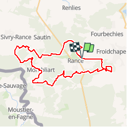
Randonnée V.T.T. de 34 km à découvrir à Wallonie, Hainaut, Sivry-Rance. Cette randonnée est proposée par pascalou73.
Description
Voilà un VTT dans la région de Rance une belle région de la bote du Hainaut . Un VTT fait de beaux sentiers dans les bois et campagne . À faire plus pas beau temps bon randonnée
Localisation
Pays :
Belgique
Région :
Wallonie
Département/Province :
Hainaut
Commune :
Sivry-Rance
Localité :
Rance
Départ:(Dec)
Départ:(UTM)
591601 ; 5555462 (31U) N.
Commentaires
Randonnées à proximité
![Randonnée V.T.C. Sivry-Rance - Sivry Gare - Robechies - Rance - Photo](https://media.geolcdn.com/t/375/260/73d602ef-978e-4b6d-980e-4af8ec05b02c.jpg&format=jpg&maxdim=2)
![V.T.C. V.T.C.](https://static1.geolcdn.com/sitytour/trail-icons/203.png)
Sivry Gare - Robechies - Rance
V.T.C.
Très facile
(2)
Sivry-Rance,
Wallonie,
Hainaut,
Belgique
![](/images/other/stat-length.png)
41 km | 48 km-effort
2h 31min
![](https://static1.geolcdn.com/siteimages/upload/files/16400158638029165_repeat_loop_refresh_sync_direction_icon.png)
Oui
![Randonnée V.T.T. Froidchapelle - Froidchapelle (7) - Promenade VTT - Photo](https://media.geolcdn.com/t/375/260/ext.jpg?maxdim=2&url=https%3A%2F%2Fservices.sitytrail.com%2FGeolivesWS%2FDownloadMedia.ashx%3FTrailID%3D332241%26Media%3D0e28cef3-8d87-404e-aa4c-8e4248f5e1b1.JPG)
![V.T.T. V.T.T.](https://static1.geolcdn.com/sitytour/trail-icons/202.png)
Froidchapelle (7) - Promenade VTT
V.T.T.
Moyen
(4)
Froidchapelle,
Wallonie,
Hainaut,
Belgique
![](/images/other/stat-length.png)
32 km | 37 km-effort
2h 26min
![](https://static1.geolcdn.com/siteimages/upload/files/16400158638029165_repeat_loop_refresh_sync_direction_icon.png)
Oui
![Randonnée Marche Sivry-Rance - Sivry-Rance (06) - Sivry - Promenade du Grand Thumas - Photo](https://media.geolcdn.com/t/375/260/ext.jpg?maxdim=2&url=https%3A%2F%2Fservices.sitytrail.com%2FGeolivesWS%2FDownloadMedia.ashx%3FTrailID%3D311164%26Media%3D8cc43fbe-f875-4530-a462-14a28c742760.JPG)
![Marche Marche](https://static1.geolcdn.com/sitytour/trail-icons/101.png)
Sivry-Rance (06) - Sivry - Promenade du Grand Thumas
Marche
Très facile
(5)
Sivry-Rance,
Wallonie,
Hainaut,
Belgique
![](/images/other/stat-length.png)
5,5 km | 6,5 km-effort
1h 30min
![](https://static1.geolcdn.com/siteimages/upload/files/16400158638029165_repeat_loop_refresh_sync_direction_icon.png)
Oui
![Randonnée Marche Sivry-Rance - RB-Ha-10 - Rance - Photo](https://media.geolcdn.com/t/375/260/ext.jpg?maxdim=2&url=https%3A%2F%2Fservices.sitytrail.com%2FGeolivesWS%2FDownloadMedia.ashx%3FTrailID%3D219204%26Media%3De74974e9-21e7-4886-b770-97222bcdf8f4.jpg)
![Marche Marche](https://static1.geolcdn.com/sitytour/trail-icons/101.png)
RB-Ha-10 - Rance
Marche
Très difficile
(1)
Sivry-Rance,
Wallonie,
Hainaut,
Belgique
![](/images/other/stat-length.png)
21 km | 25 km-effort
5h 47min
![](https://static1.geolcdn.com/siteimages/upload/files/16400158638029165_repeat_loop_refresh_sync_direction_icon.png)
Oui
![Randonnée Marche Sivry-Rance - Sivry-Rance (13) - Promenade de la Vallée de l'Eau d'Eppe - Photo](https://media.geolcdn.com/t/375/260/ext.jpg?maxdim=2&url=https%3A%2F%2Fservices.sitytrail.com%2FGeolivesWS%2FDownloadMedia.ashx%3FTrailID%3D311163%26Media%3Db7af1830-b06f-43cc-9ab9-a464f12aaa86.JPG)
![Marche Marche](https://static1.geolcdn.com/sitytour/trail-icons/101.png)
Sivry-Rance (13) - Promenade de la Vallée de l'Eau d'Eppe
Marche
Très facile
(2)
Sivry-Rance,
Wallonie,
Hainaut,
Belgique
![](/images/other/stat-length.png)
6,6 km | 8,4 km-effort
2h 0min
![](https://static1.geolcdn.com/siteimages/upload/files/16400158638029165_repeat_loop_refresh_sync_direction_icon.png)
Oui
![Randonnée Marche Sivry-Rance - De Sautin vers Montbliart par la vallee de l'Eau d'Eppe - Photo](https://media.geolcdn.com/t/375/260/ext.jpg?maxdim=2&url=https%3A%2F%2Fstatic1.geolcdn.com%2Fsiteimages%2Fupload%2Ffiles%2F1553511878bg_sport_marche.png)
![Marche Marche](https://static1.geolcdn.com/sitytour/trail-icons/101.png)
De Sautin vers Montbliart par la vallee de l'Eau d'Eppe
Marche
Moyen
(1)
Sivry-Rance,
Wallonie,
Hainaut,
Belgique
![](/images/other/stat-length.png)
17,3 km | 21 km-effort
4h 20min
![](https://static1.geolcdn.com/siteimages/upload/files/16400158638029165_repeat_loop_refresh_sync_direction_icon.png)
Oui
![Randonnée Marche Froidchapelle - La balade du bois du Grand Oupia aux lacs de l'eau d'heure - Photo](https://media.geolcdn.com/t/375/260/73ecda4c-85a4-4092-8a72-382e3ad583a2.jpg&format=jpg&maxdim=2)
![Marche Marche](https://static1.geolcdn.com/sitytour/trail-icons/101.png)
La balade du bois du Grand Oupia aux lacs de l'eau d'heure
Marche
Moyen
(4)
Froidchapelle,
Wallonie,
Hainaut,
Belgique
![](/images/other/stat-length.png)
8,7 km | 9,9 km-effort
2h 15min
![](https://static1.geolcdn.com/siteimages/upload/files/16400158638029165_repeat_loop_refresh_sync_direction_icon.png)
Oui
![Randonnée A pied Sivry-Rance - Promenade du Ry d'Hernoy - Photo](https://media.geolcdn.com/t/375/260/3576f0ab-5152-4ef1-90e0-3b37b935b6bd.jpeg&format=jpg&maxdim=2)
![A pied A pied](https://static1.geolcdn.com/sitytour/trail-icons/100.png)
Promenade du Ry d'Hernoy
A pied
Facile
Sivry-Rance,
Wallonie,
Hainaut,
Belgique
![](/images/other/stat-length.png)
9,8 km | 11,8 km-effort
2h 41min
![](https://static1.geolcdn.com/siteimages/upload/files/16400158638029165_repeat_loop_refresh_sync_direction_icon.png)
Oui
![Randonnée A pied Sivry-Rance - Promenade circulaire de l'Ermitage - Photo](https://media.geolcdn.com/t/375/260/ext.jpg?maxdim=2&url=https%3A%2F%2Fpivotmedia.tourismewallonie.be%2FOTH-A0-004E-1IGH%2FOTH-A0-004E-1IGH.jpg)
![A pied A pied](https://static1.geolcdn.com/sitytour/trail-icons/100.png)
Promenade circulaire de l'Ermitage
A pied
Facile
Sivry-Rance,
Wallonie,
Hainaut,
Belgique
![](/images/other/stat-length.png)
4,7 km | 5,5 km-effort
1h 15min
![](https://static1.geolcdn.com/siteimages/upload/files/16400158638029165_repeat_loop_refresh_sync_direction_icon.png)
Oui