![](/images/other/stat-length.png)
![Randonnée Marche Saint-Hubert - MIRWART(St-Roch) - Photo](https://media.geolcdn.com/t/1900/400/ext.pjpeg?maxdim=2&url=https%3A%2F%2Fservices.sitytrail.com%2FGeolivesWS%2FDownloadMedia.ashx%3FTrailID%3D925663%26Media%3Dfix__20180318122411.jpg)
MIRWART(St-Roch)
GerardBouche
Utilisateur
![Longueur](/images/other/stat-length.png)
Longueur
6,5 km
![Altitude max](https://static1.geolcdn.com/siteimages/upload/files/1508320355ic_sort_altitude_max_24dp.png)
Altitude max
336 m
![Dénivelé positif](https://static1.geolcdn.com/siteimages/upload/files/1508320355ic_sort_den_pos_24dp.png)
Dénivelé positif
135 m
![Km-Effort](/images/other/stat-length.png)
Km-Effort
8,3 km
![Altitude min](https://static1.geolcdn.com/siteimages/upload/files/1508320355ic_sort_altitude_min_24dp.png)
Altitude min
258 m
![Dénivelé négatif](https://static1.geolcdn.com/siteimages/upload/files/1508320355ic_sort_den_neg_24dp.png)
Dénivelé négatif
136 m
![Boucle](https://static1.geolcdn.com/siteimages/upload/files/16400158638029165_repeat_loop_refresh_sync_direction_icon.png)
Boucle
Oui
Date de création :
2018-04-17 22:12:16.574
Dernière modification :
2018-04-17 22:12:16.574
![Marche](https://static1.geolcdn.com/sitytour/trail-icons/101.png)
1h56
Difficulté : Facile
![Scannez ce code QR pour ouvrir la randonnée dans l'application SityTrail](https://capi.geolives.com/qq0zvz2zws4bq2lad0pu/sitytour/trails/925663/qr.png?size=200)
Application GPS de randonnée GRATUITE
À propos
Randonnée Marche de 6,5 km à découvrir à Wallonie, Luxembourg, Saint-Hubert. Cette randonnée est proposée par GerardBouche.
Description
Petite balade sympa par l'étang St-Roch, l'ancienne glacière devenue refuge pour pipistrelles, la rive droite de la Lomme et les étangs de la pisciculture provinciale.
Localisation
Pays :
Belgique
Région :
Wallonie
Département/Province :
Luxembourg
Commune :
Saint-Hubert
Localité :
Mirwart
Départ:(Dec)
Départ:(UTM)
662097 ; 5547357 (31U) N.
Commentaires
Randonnées à proximité
![Randonnée Marche Tellin - Tellin. Natura 2000, des sites qui valent le détour ! Lx 7 - Photo](https://media.geolcdn.com/t/375/260/ext.jpg?maxdim=2&url=https%3A%2F%2Fservices.sitytrail.com%2FGeolivesWS%2FDownloadMedia.ashx%3FTrailID%3D139723%26Media%3D4b6cd866-c01c-4092-b3ae-893d48db31d3.JPG)
![Marche Marche](https://static1.geolcdn.com/sitytour/trail-icons/101.png)
Tellin. Natura 2000, des sites qui valent le détour ! Lx 7
Marche
Moyen
(7)
Tellin,
Wallonie,
Luxembourg,
Belgique
![](/images/other/stat-length.png)
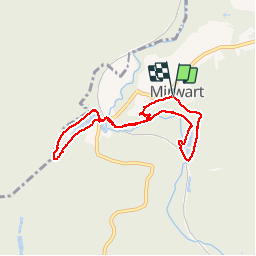
9,6 km | 11,9 km-effort
1h 30min
![](https://static1.geolcdn.com/siteimages/upload/files/16400158638029165_repeat_loop_refresh_sync_direction_icon.png)
Oui
![Randonnée Marche Saint-Hubert - Poix - Sainte-Adeline (SH15) - Photo](https://media.geolcdn.com/t/375/260/ext.jpg?maxdim=2&url=https%3A%2F%2Fservices.sitytrail.com%2FGeolivesWS%2FDownloadMedia.ashx%3FTrailID%3D334489%26Media%3Dff5c6d1c-0697-4565-9157-6580a8b8d275.jpg)
![Marche Marche](https://static1.geolcdn.com/sitytour/trail-icons/101.png)
Poix - Sainte-Adeline (SH15)
Marche
Moyen
(7)
Saint-Hubert,
Wallonie,
Luxembourg,
Belgique
![](/images/other/stat-length.png)
8,3 km | 10,8 km-effort
2h 23min
![](https://static1.geolcdn.com/siteimages/upload/files/16400158638029165_repeat_loop_refresh_sync_direction_icon.png)
Oui
![Randonnée Marche Saint-Hubert - Mirwart_Vieux Moulin de Mirwart_Alternative Forêt (SH29 bis) - Photo](https://media.geolcdn.com/t/375/260/ext.jpg?maxdim=2&url=https%3A%2F%2Fservices.sitytrail.com%2FGeolivesWS%2FDownloadMedia.ashx%3FTrailID%3D366988%26Media%3D029a75cb-b10f-4900-87ea-e92327ef26cb.jpg)
![Marche Marche](https://static1.geolcdn.com/sitytour/trail-icons/101.png)
Mirwart_Vieux Moulin de Mirwart_Alternative Forêt (SH29 bis)
Marche
Difficile
(12)
Saint-Hubert,
Wallonie,
Luxembourg,
Belgique
![](/images/other/stat-length.png)
10,8 km | 14,2 km-effort
3h 4min
![](https://static1.geolcdn.com/siteimages/upload/files/16400158638029165_repeat_loop_refresh_sync_direction_icon.png)
Oui
![Randonnée Marche Saint-Hubert - Marche ADEPS Arville - Photo](https://media.geolcdn.com/t/375/260/3bbd3001-2495-4fe0-a9c1-b38774f0038e.jpg&format=jpg&maxdim=2)
![Marche Marche](https://static1.geolcdn.com/sitytour/trail-icons/101.png)
Marche ADEPS Arville
Marche
Moyen
(1)
Saint-Hubert,
Wallonie,
Luxembourg,
Belgique
![](/images/other/stat-length.png)
10,2 km | 13,6 km-effort
2h 13min
![](https://static1.geolcdn.com/siteimages/upload/files/16400158638029165_repeat_loop_refresh_sync_direction_icon.png)
Oui
![Randonnée Marche Tellin - RL-GG-13_Grupont_Poix-Saint-Hubert - Photo](https://media.geolcdn.com/t/375/260/5959367f-35e5-42da-bbcc-7bf6a947c3d1.jpg&format=jpg&maxdim=2)
![Marche Marche](https://static1.geolcdn.com/sitytour/trail-icons/101.png)
RL-GG-13_Grupont_Poix-Saint-Hubert
Marche
Très difficile
(3)
Tellin,
Wallonie,
Luxembourg,
Belgique
![](/images/other/stat-length.png)
26 km | 34 km-effort
7h 23min
![](https://static1.geolcdn.com/siteimages/upload/files/16400158638029165_repeat_loop_refresh_sync_direction_icon.png)
Non
![Randonnée Marche Tellin - Balade à Grupont - Photo](https://media.geolcdn.com/t/375/260/ext.jpg?maxdim=2&url=https%3A%2F%2Fservices.sitytrail.com%2FGeolivesWS%2FDownloadMedia.ashx%3FTrailID%3D963883%26Media%3D35fabe2c-0877-4435-b4f9-1ab0863175f9.jpg)
![Marche Marche](https://static1.geolcdn.com/sitytour/trail-icons/101.png)
Balade à Grupont
Marche
Facile
(1)
Tellin,
Wallonie,
Luxembourg,
Belgique
![](/images/other/stat-length.png)
8,4 km | 11,9 km-effort
2h 33min
![](https://static1.geolcdn.com/siteimages/upload/files/16400158638029165_repeat_loop_refresh_sync_direction_icon.png)
Oui
![Randonnée Marche Tellin - Bure - Promenade des chapelles - Photo](https://media.geolcdn.com/t/375/260/ext.jpg?maxdim=2&url=https%3A%2F%2Fservices.sitytrail.com%2FGeolivesWS%2FDownloadMedia.ashx%3FTrailID%3D551016%26Media%3D367a68c9-5f59-4fbe-aa6c-c01d282ce6b9.jpg)
![Marche Marche](https://static1.geolcdn.com/sitytour/trail-icons/101.png)
Bure - Promenade des chapelles
Marche
Facile
(1)
Tellin,
Wallonie,
Luxembourg,
Belgique
![](/images/other/stat-length.png)
4,5 km | 5,9 km-effort
1h 15min
![](https://static1.geolcdn.com/siteimages/upload/files/16400158638029165_repeat_loop_refresh_sync_direction_icon.png)
Oui
![Randonnée Marche Tellin - Tellin - Promenade du trou des Lûtons - Photo](https://media.geolcdn.com/t/375/260/ext.jpg?maxdim=2&url=https%3A%2F%2Fservices.sitytrail.com%2FGeolivesWS%2FDownloadMedia.ashx%3FTrailID%3D334609%26Media%3D72f7acea-f8a9-4ab8-824e-7af5347c7927.JPG)
![Marche Marche](https://static1.geolcdn.com/sitytour/trail-icons/101.png)
Tellin - Promenade du trou des Lûtons
Marche
Facile
(1)
Tellin,
Wallonie,
Luxembourg,
Belgique
![](/images/other/stat-length.png)
5,2 km | 6,1 km-effort
1h 21min
![](https://static1.geolcdn.com/siteimages/upload/files/16400158638029165_repeat_loop_refresh_sync_direction_icon.png)
Oui
![Randonnée A pied Tellin - Tellin - Promenade des étangs - Photo](https://media.geolcdn.com/t/375/260/ext.jpg?maxdim=2&url=https%3A%2F%2Fservices.sitytrail.com%2FGeolivesWS%2FDownloadMedia.ashx%3FTrailID%3D334608%26Media%3Da58f89aa-1898-4e28-81bb-4a136e02b6ff.jpg)
![A pied A pied](https://static1.geolcdn.com/sitytour/trail-icons/100.png)
Tellin - Promenade des étangs
A pied
Moyen
(2)
Tellin,
Wallonie,
Luxembourg,
Belgique
![](/images/other/stat-length.png)
20 km | 27 km-effort
Inconnu
![](https://static1.geolcdn.com/siteimages/upload/files/16400158638029165_repeat_loop_refresh_sync_direction_icon.png)
Oui
Veel langer dan aangegeven. Je kunt wel een stuk afsnijden na het meer. Verder een prachtige wandeling.