![](/images/other/stat-length.png)
![Randonnée Marche Ohey - Goesnes et Hodoumont - Photo](https://media.geolcdn.com/t/1900/400/ext.pjpeg?maxdim=2&url=https%3A%2F%2Fstatic1.geolcdn.com%2Fsiteimages%2Fupload%2Ffiles%2F1553511878bg_sport_marche.png)
Goesnes et Hodoumont
Vallées des Saveurs - Maison du Tourisme Condroz-Famenne
Destination Condroz-Famenne- une nature préservée PRO
![Longueur](/images/other/stat-length.png)
Longueur
8,6 km
![Altitude max](https://static1.geolcdn.com/siteimages/upload/files/1508320355ic_sort_altitude_max_24dp.png)
Altitude max
285 m
![Dénivelé positif](https://static1.geolcdn.com/siteimages/upload/files/1508320355ic_sort_den_pos_24dp.png)
Dénivelé positif
129 m
![Km-Effort](/images/other/stat-length.png)
Km-Effort
10,3 km
![Altitude min](https://static1.geolcdn.com/siteimages/upload/files/1508320355ic_sort_altitude_min_24dp.png)
Altitude min
202 m
![Dénivelé négatif](https://static1.geolcdn.com/siteimages/upload/files/1508320355ic_sort_den_neg_24dp.png)
Dénivelé négatif
126 m
![Boucle](https://static1.geolcdn.com/siteimages/upload/files/16400158638029165_repeat_loop_refresh_sync_direction_icon.png)
Boucle
Oui
Date de création :
2018-04-09 13:03:39.574
Dernière modification :
2018-04-09 13:03:39.574
![Marche](https://static1.geolcdn.com/sitytour/trail-icons/101.png)
2h15
Difficulté : Facile
![Scannez ce code QR pour ouvrir la randonnée dans l'application SityTrail](https://capi.geolives.com/qq0zvz2zws4bq2lad0pu/sitytour/trails/921986/qr.png?size=200)
Application GPS de randonnée GRATUITE
À propos
Randonnée Marche de 8,6 km à découvrir à Wallonie, Namur, Ohey. Cette randonnée est proposée par Vallées des Saveurs - Maison du Tourisme Condroz-Famenne.
Description
Promenade Goesnes -Hodoumont
Localisation
Pays :
Belgique
Région :
Wallonie
Département/Province :
Namur
Commune :
Ohey
Localité :
Goesnes
Départ:(Dec)
Départ:(UTM)
657392 ; 5590019 (31U) N.
Commentaires
Randonnées à proximité
![Randonnée Marche Clavier - RB-Lg-01_Pailhe_via-racc - Photo](https://media.geolcdn.com/t/375/260/ext.jpg?maxdim=2&url=https%3A%2F%2Fservices.sitytrail.com%2FGeolivesWS%2FDownloadMedia.ashx%3FTrailID%3D209390%26Media%3D22266d26-9089-4b3a-b5ae-a6da953afba4.jpg)
![Marche Marche](https://static1.geolcdn.com/sitytour/trail-icons/101.png)
RB-Lg-01_Pailhe_via-racc
Marche
Moyen
(8)
Clavier,
Wallonie,
Liège,
Belgique
![](/images/other/stat-length.png)
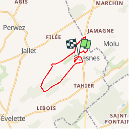
17,1 km | 21 km-effort
4h 34min
![](https://static1.geolcdn.com/siteimages/upload/files/16400158638029165_repeat_loop_refresh_sync_direction_icon.png)
Oui
![Randonnée Marche Clavier - RB-Lg-01_Pailhe - Photo](https://media.geolcdn.com/t/375/260/ext.jpg?maxdim=2&url=https%3A%2F%2Fservices.sitytrail.com%2FGeolivesWS%2FDownloadMedia.ashx%3FTrailID%3D179556%26Media%3D22266d26-9089-4b3a-b5ae-a6da953afba4.jpg)
![Marche Marche](https://static1.geolcdn.com/sitytour/trail-icons/101.png)
RB-Lg-01_Pailhe
Marche
Moyen
(12)
Clavier,
Wallonie,
Liège,
Belgique
![](/images/other/stat-length.png)
20 km | 25 km-effort
5h 23min
![](https://static1.geolcdn.com/siteimages/upload/files/16400158638029165_repeat_loop_refresh_sync_direction_icon.png)
Oui
![Randonnée Marche Ohey - OHEY- Evelette (Libois)- N° 13 Eau - Photo](https://media.geolcdn.com/t/375/260/ext.jpg?maxdim=2&url=https%3A%2F%2Fservices.sitytrail.com%2FGeolivesWS%2FDownloadMedia.ashx%3FTrailID%3D121420%26Media%3Dde7ff550-e553-4241-aaa7-7bac1b671239.jpg)
![Marche Marche](https://static1.geolcdn.com/sitytour/trail-icons/101.png)
OHEY- Evelette (Libois)- N° 13 Eau
Marche
Facile
(7)
Ohey,
Wallonie,
Namur,
Belgique
![](/images/other/stat-length.png)
12,1 km | 14,4 km-effort
2h 11min
![](https://static1.geolcdn.com/siteimages/upload/files/16400158638029165_repeat_loop_refresh_sync_direction_icon.png)
Oui
![Randonnée Marche Ohey - OHEY- Haillot- N°12-Bois - Photo](https://media.geolcdn.com/t/375/260/ext.jpg?maxdim=2&url=https%3A%2F%2Fservices.sitytrail.com%2FGeolivesWS%2FDownloadMedia.ashx%3FTrailID%3D121419%26Media%3Dd288ef38-31a8-435a-872c-4c8caba863e7.JPG)
![Marche Marche](https://static1.geolcdn.com/sitytour/trail-icons/101.png)
OHEY- Haillot- N°12-Bois
Marche
Facile
(5)
Ohey,
Wallonie,
Namur,
Belgique
![](/images/other/stat-length.png)
6,6 km | 7,9 km-effort
1h 42min
![](https://static1.geolcdn.com/siteimages/upload/files/16400158638029165_repeat_loop_refresh_sync_direction_icon.png)
Oui
![Randonnée Marche Clavier - CLAVIER - La Romantique - Photo](https://media.geolcdn.com/t/375/260/ext.jpg?maxdim=2&url=https%3A%2F%2Fservices.sitytrail.com%2FGeolivesWS%2FDownloadMedia.ashx%3FTrailID%3D162888%26Media%3D9ae93777-447a-4289-aab4-f0814b4e414d.jpg)
![Marche Marche](https://static1.geolcdn.com/sitytour/trail-icons/101.png)
CLAVIER - La Romantique
Marche
Facile
(11)
Clavier,
Wallonie,
Liège,
Belgique
![](/images/other/stat-length.png)
12,6 km | 15,3 km-effort
3h 18min
![](https://static1.geolcdn.com/siteimages/upload/files/16400158638029165_repeat_loop_refresh_sync_direction_icon.png)
Oui
![Randonnée Marche Marchin - MARCHIN - Chemin de la Mémoire - Photo](https://media.geolcdn.com/t/375/260/ext.jpg?maxdim=2&url=https%3A%2F%2Fservices.sitytrail.com%2FGeolivesWS%2FDownloadMedia.ashx%3FTrailID%3D134945%26Media%3D9baec6a8-ffff-4223-8cd2-41c1e7b6afda.jpg)
![Marche Marche](https://static1.geolcdn.com/sitytour/trail-icons/101.png)
MARCHIN - Chemin de la Mémoire
Marche
Moyen
(5)
Marchin,
Wallonie,
Liège,
Belgique
![](/images/other/stat-length.png)
9 km | 11 km-effort
2h 15min
![](https://static1.geolcdn.com/siteimages/upload/files/16400158638029165_repeat_loop_refresh_sync_direction_icon.png)
Oui
![Marche Marche](https://static1.geolcdn.com/sitytour/trail-icons/101.png)
Sentiers d'Art : Boucle 13 - Jallet
Marche
Difficile
(4)
Ohey,
Wallonie,
Namur,
Belgique
![](/images/other/stat-length.png)
11,9 km | 14,3 km-effort
3h 15min
![](https://static1.geolcdn.com/siteimages/upload/files/16400158638029165_repeat_loop_refresh_sync_direction_icon.png)
Oui
![Randonnée Marche Havelange - HAVELANGE- Ossogne- Promenade du Bois du Clavia - Photo](https://media.geolcdn.com/t/375/260/ext.jpg?maxdim=2&url=https%3A%2F%2Fservices.sitytrail.com%2FGeolivesWS%2FDownloadMedia.ashx%3FTrailID%3D250694%26Media%3Dc7236ce6-12d1-4d24-9b34-c449eda1935c.jpg)
![Marche Marche](https://static1.geolcdn.com/sitytour/trail-icons/101.png)
HAVELANGE- Ossogne- Promenade du Bois du Clavia
Marche
Très facile
(2)
Havelange,
Wallonie,
Namur,
Belgique
![](/images/other/stat-length.png)
3,2 km | 4 km-effort
51min
![](https://static1.geolcdn.com/siteimages/upload/files/16400158638029165_repeat_loop_refresh_sync_direction_icon.png)
Oui
![Randonnée Marche Ohey - OHEY- Jallet (Hodoumont) N°14 Patrimoine - Photo](https://media.geolcdn.com/t/375/260/ext.jpg?maxdim=2&url=https%3A%2F%2Fservices.sitytrail.com%2FGeolivesWS%2FDownloadMedia.ashx%3FTrailID%3D121421%26Media%3D17893d9b-46b6-4b6b-a31d-e8bf45aab994.jpg)
![Marche Marche](https://static1.geolcdn.com/sitytour/trail-icons/101.png)
OHEY- Jallet (Hodoumont) N°14 Patrimoine
Marche
Facile
(4)
Ohey,
Wallonie,
Namur,
Belgique
![](/images/other/stat-length.png)
9,6 km | 10,9 km-effort
2h 11min
![](https://static1.geolcdn.com/siteimages/upload/files/16400158638029165_repeat_loop_refresh_sync_direction_icon.png)
Oui