![](/images/other/stat-length.png)
![Randonnée V.T.T. Cherbourg-en-Cotentin - Ravalet anse du Brick - Photo](https://media.geolcdn.com/t/1900/400/ext.pjpeg?maxdim=2&url=https%3A%2F%2Fstatic1.geolcdn.com%2Fsiteimages%2Fupload%2Ffiles%2F1524743154velo.jpg)
Ravalet anse du Brick
ves
Utilisateur
![Longueur](/images/other/stat-length.png)
Longueur
46 km
![Altitude max](https://static1.geolcdn.com/siteimages/upload/files/1508320355ic_sort_altitude_max_24dp.png)
Altitude max
149 m
![Dénivelé positif](https://static1.geolcdn.com/siteimages/upload/files/1508320355ic_sort_den_pos_24dp.png)
Dénivelé positif
632 m
![Km-Effort](/images/other/stat-length.png)
Km-Effort
55 km
![Altitude min](https://static1.geolcdn.com/siteimages/upload/files/1508320355ic_sort_altitude_min_24dp.png)
Altitude min
-1 m
![Dénivelé négatif](https://static1.geolcdn.com/siteimages/upload/files/1508320355ic_sort_den_neg_24dp.png)
Dénivelé négatif
651 m
![Boucle](https://static1.geolcdn.com/siteimages/upload/files/16400158638029165_repeat_loop_refresh_sync_direction_icon.png)
Boucle
Non
Date de création :
2018-04-17 21:13:26.127
Dernière modification :
2018-04-17 21:13:26.127
![V.T.T.](https://static1.geolcdn.com/sitytour/trail-icons/202.png)
3h58
Difficulté : Moyen
![Scannez ce code QR pour ouvrir la randonnée dans l'application SityTrail](https://capi.geolives.com/qq0zvz2zws4bq2lad0pu/sitytour/trails/919461/qr.png?size=200)
Application GPS de randonnée GRATUITE
À propos
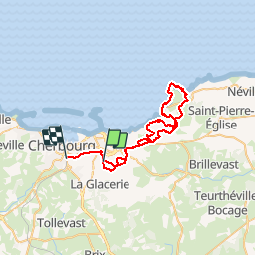
Randonnée V.T.T. de 46 km à découvrir à Normandie, Manche, Cherbourg-en-Cotentin. Cette randonnée est proposée par ves.
Description
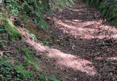
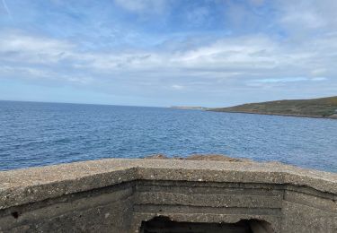
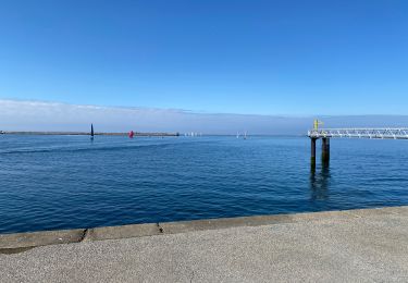
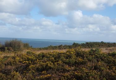
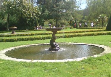
Petit tour avec le club des Haguards en partant du château des Ravalet sur des chemins roulants vers l'anse du Brick puis le littoral sous cette belle lumière...
Localisation
Pays :
France
Région :
Normandie
Département/Province :
Manche
Commune :
Cherbourg-en-Cotentin
Localité :
Tourlaville
Départ:(Dec)
Départ:(UTM)
603475 ; 5498307 (30U) N.
Commentaires
Randonnées à proximité
![Randonnée A pied Cherbourg-en-Cotentin - Séjour Cotentin Etape 7 Boucle Cherbourg avant départ - Photo](https://media.geolcdn.com/t/375/260/ecdd6e0d-0f77-43a1-9488-9c5e48720411.jpg&format=jpg&maxdim=2)
![A pied A pied](https://static1.geolcdn.com/sitytour/trail-icons/100.png)
Séjour Cotentin Etape 7 Boucle Cherbourg avant départ
A pied
Facile
Cherbourg-en-Cotentin,
Normandie,
Manche,
France
![](/images/other/stat-length.png)
12,2 km | 14,9 km-effort
3h 22min
![](https://static1.geolcdn.com/siteimages/upload/files/16400158638029165_repeat_loop_refresh_sync_direction_icon.png)
Non
![Randonnée Marche Cherbourg-en-Cotentin - La Glacerie - Photo](https://media.geolcdn.com/t/375/260/d538c617-51e8-4dc1-9179-9dd9282dc35e.jpg&format=jpg&maxdim=2)
![Marche Marche](https://static1.geolcdn.com/sitytour/trail-icons/101.png)
La Glacerie
Marche
Facile
Cherbourg-en-Cotentin,
Normandie,
Manche,
France
![](/images/other/stat-length.png)
6,6 km | 8,7 km-effort
1h 26min
![](https://static1.geolcdn.com/siteimages/upload/files/16400158638029165_repeat_loop_refresh_sync_direction_icon.png)
Oui
![Randonnée Marche Bretteville - Bretteville Pointe de la Bricq - Photo](https://media.geolcdn.com/t/375/260/209219c0-94e3-47ef-bd3d-ccc00af85e15.jpg&format=jpg&maxdim=2)
![Marche Marche](https://static1.geolcdn.com/sitytour/trail-icons/101.png)
Bretteville Pointe de la Bricq
Marche
Bretteville,
Normandie,
Manche,
France
![](/images/other/stat-length.png)
7,3 km | 8,3 km-effort
2h 19min
![](https://static1.geolcdn.com/siteimages/upload/files/16400158638029165_repeat_loop_refresh_sync_direction_icon.png)
Oui
![Randonnée Vélo de route Cherbourg-en-Cotentin - Autour de Cherbourg en vélo - Photo](https://media.geolcdn.com/t/375/260/e98822be-3a7d-4320-ad41-408bde740599.jpg&format=jpg&maxdim=2)
![Vélo de route Vélo de route](https://static1.geolcdn.com/sitytour/trail-icons/201.png)
Autour de Cherbourg en vélo
Vélo de route
Très facile
Cherbourg-en-Cotentin,
Normandie,
Manche,
France
![](/images/other/stat-length.png)
24 km | 26 km-effort
2h 12min
![](https://static1.geolcdn.com/siteimages/upload/files/16400158638029165_repeat_loop_refresh_sync_direction_icon.png)
Oui
![Randonnée Marche Cherbourg-en-Cotentin - Tourlaville : 22 octobre 2017 - Photo](https://media.geolcdn.com/t/375/260/ext.jpg?maxdim=2&url=https%3A%2F%2Fservices.sitytrail.com%2FGeolivesWS%2FDownloadMedia.ashx%3FTrailID%3D849892%26Media%3Dfix__20171022112721.jpg)
![Marche Marche](https://static1.geolcdn.com/sitytour/trail-icons/101.png)
Tourlaville : 22 octobre 2017
Marche
Facile
Cherbourg-en-Cotentin,
Normandie,
Manche,
France
![](/images/other/stat-length.png)
6,2 km | 7,5 km-effort
1h 2min
![](https://static1.geolcdn.com/siteimages/upload/files/16400158638029165_repeat_loop_refresh_sync_direction_icon.png)
Oui
![Randonnée V.T.T. Cherbourg-en-Cotentin - Relais des 4 châteaux 2013 - Tourlaville - Photo](https://media.geolcdn.com/t/375/260/ext.jpg?maxdim=2&url=https%3A%2F%2Fservices.sitytrail.com%2FGeolivesWS%2FDownloadMedia.ashx%3FTrailID%3D191595%26Media%3D15228_3.jpg)
![V.T.T. V.T.T.](https://static1.geolcdn.com/sitytour/trail-icons/202.png)
Relais des 4 châteaux 2013 - Tourlaville
V.T.T.
Difficile
Cherbourg-en-Cotentin,
Normandie,
Manche,
France
![](/images/other/stat-length.png)
30 km | 38 km-effort
3h 0min
![](https://static1.geolcdn.com/siteimages/upload/files/16400158638029165_repeat_loop_refresh_sync_direction_icon.png)
Oui
![Randonnée Marche Cherbourg-en-Cotentin - Le colignon - Photo](https://media.geolcdn.com/t/375/260/ext.jpg?maxdim=2&url=https%3A%2F%2Fstatic1.geolcdn.com%2Fsiteimages%2Fupload%2Ffiles%2F1553511878bg_sport_marche.png)
![Marche Marche](https://static1.geolcdn.com/sitytour/trail-icons/101.png)
Le colignon
Marche
Très facile
(1)
Cherbourg-en-Cotentin,
Normandie,
Manche,
France
![](/images/other/stat-length.png)
5,8 km | 7,2 km-effort
1h 34min
![](https://static1.geolcdn.com/siteimages/upload/files/16400158638029165_repeat_loop_refresh_sync_direction_icon.png)
Oui
![Randonnée Marche Cherbourg-en-Cotentin - Les chemins de Saint- Michel - Cherbourg - Lessay - Photo](https://media.geolcdn.com/t/375/260/ext.jpg?maxdim=2&url=https%3A%2F%2Fservices.sitytrail.com%2FGeolivesWS%2FDownloadMedia.ashx%3FTrailID%3D112747%26Media%3D11878_6.jpg)
![Marche Marche](https://static1.geolcdn.com/sitytour/trail-icons/101.png)
Les chemins de Saint- Michel - Cherbourg - Lessay
Marche
Moyen
Cherbourg-en-Cotentin,
Normandie,
Manche,
France
![](/images/other/stat-length.png)
91 km | 103 km-effort
Inconnu
![](https://static1.geolcdn.com/siteimages/upload/files/16400158638029165_repeat_loop_refresh_sync_direction_icon.png)
Non
![Randonnée Marche Cherbourg-en-Cotentin - GR 223 - de Cherbourg à Flamanville - Photo](https://media.geolcdn.com/t/375/260/ext.jpg?maxdim=2&url=https%3A%2F%2Fstatic1.geolcdn.com%2Fsiteimages%2Fupload%2Ffiles%2F1553511878bg_sport_marche.png)
![Marche Marche](https://static1.geolcdn.com/sitytour/trail-icons/101.png)
GR 223 - de Cherbourg à Flamanville
Marche
Moyen
(1)
Cherbourg-en-Cotentin,
Normandie,
Manche,
France
![](/images/other/stat-length.png)
70 km | 87 km-effort
16h 0min
![](https://static1.geolcdn.com/siteimages/upload/files/16400158638029165_repeat_loop_refresh_sync_direction_icon.png)
Non