![](/images/other/stat-length.png)
![Randonnée Marche Moisenay - Moisenay - Photo](https://media.geolcdn.com/t/1900/400/ext.pjpeg?maxdim=2&url=https%3A%2F%2Fstatic1.geolcdn.com%2Fsiteimages%2Fupload%2Ffiles%2F1553511878bg_sport_marche.png)
Moisenay
aucamus
Utilisateur
![Longueur](/images/other/stat-length.png)
Longueur
7,6 km
![Altitude max](https://static1.geolcdn.com/siteimages/upload/files/1508320355ic_sort_altitude_max_24dp.png)
Altitude max
99 m
![Dénivelé positif](https://static1.geolcdn.com/siteimages/upload/files/1508320355ic_sort_den_pos_24dp.png)
Dénivelé positif
133 m
![Km-Effort](/images/other/stat-length.png)
Km-Effort
9,4 km
![Altitude min](https://static1.geolcdn.com/siteimages/upload/files/1508320355ic_sort_altitude_min_24dp.png)
Altitude min
59 m
![Dénivelé négatif](https://static1.geolcdn.com/siteimages/upload/files/1508320355ic_sort_den_neg_24dp.png)
Dénivelé négatif
135 m
![Boucle](https://static1.geolcdn.com/siteimages/upload/files/16400158638029165_repeat_loop_refresh_sync_direction_icon.png)
Boucle
Oui
Date de création :
2019-05-27 14:31:38.967
Dernière modification :
2019-05-27 14:31:39.156
![Marche](https://static1.geolcdn.com/sitytour/trail-icons/101.png)
2h00
Difficulté : Très facile
![Scannez ce code QR pour ouvrir la randonnée dans l'application SityTrail](https://capi.geolives.com/qq0zvz2zws4bq2lad0pu/sitytour/trails/906357/qr.png?size=200)
Application GPS de randonnée GRATUITE
À propos
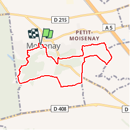
Randonnée Marche de 7,6 km à découvrir à Île-de-France, Seine-et-Marne, Moisenay. Cette randonnée est proposée par aucamus.
Description
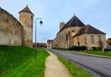
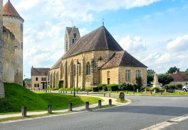
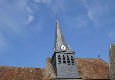
Départ et arrivée Eglise catholique de Moisenay via
Eglise orthodoxe de Notre Dame de Kazan à Moisenay
contact de la communauté :
Olga Platonova 06 81 85 73 43
email : latonova.o@gmail.com
Localisation
Pays :
France
Région :
Île-de-France
Département/Province :
Seine-et-Marne
Commune :
Moisenay
Localité :
Unknown
Départ:(Dec)
Départ:(UTM)
480449 ; 5378815 (31U) N.
Commentaires
Randonnées à proximité
![Randonnée Marche Blandy - JC 52 Eglises Médiévales de la Brie, La Collégiale de Champeaux - Photo](https://media.geolcdn.com/t/375/260/aed965fb-0abe-4a92-b759-defb35e3ca63.jpg&format=jpg&maxdim=2)
![Marche Marche](https://static1.geolcdn.com/sitytour/trail-icons/101.png)
JC 52 Eglises Médiévales de la Brie, La Collégiale de Champeaux
Marche
Difficile
(2)
Blandy,
Île-de-France,
Seine-et-Marne,
France
![](/images/other/stat-length.png)
20 km | 22 km-effort
5h 5min
![](https://static1.geolcdn.com/siteimages/upload/files/16400158638029165_repeat_loop_refresh_sync_direction_icon.png)
Oui
![Randonnée Marche Blandy - Boucle 23 km Blandy - St Merry - Bombon - Champeaux - Photo](https://media.geolcdn.com/t/375/260/810a2001-48d6-47b8-9b9c-600abddda76e.jpg&format=jpg&maxdim=2)
![Marche Marche](https://static1.geolcdn.com/sitytour/trail-icons/101.png)
Boucle 23 km Blandy - St Merry - Bombon - Champeaux
Marche
Moyen
Blandy,
Île-de-France,
Seine-et-Marne,
France
![](/images/other/stat-length.png)
23 km | 25 km-effort
5h 42min
![](https://static1.geolcdn.com/siteimages/upload/files/16400158638029165_repeat_loop_refresh_sync_direction_icon.png)
Oui
![Randonnée Marche Blandy - Boucle 21 km Blandy - Bombom - St Mery - Champeaux - Photo](https://media.geolcdn.com/t/375/260/a365a7e1-c890-4e35-bd6d-01d4e699b3cc.jpg&format=jpg&maxdim=2)
![Marche Marche](https://static1.geolcdn.com/sitytour/trail-icons/101.png)
Boucle 21 km Blandy - Bombom - St Mery - Champeaux
Marche
Facile
Blandy,
Île-de-France,
Seine-et-Marne,
France
![](/images/other/stat-length.png)
21 km | 23 km-effort
4h 44min
![](https://static1.geolcdn.com/siteimages/upload/files/16400158638029165_repeat_loop_refresh_sync_direction_icon.png)
Oui
![Randonnée Marche Blandy - Boucle autour de Blandy par Corinne - Photo](https://media.geolcdn.com/t/375/260/e1753442-473d-4613-9ca0-8082f000c750.jpg&format=jpg&maxdim=2)
![Marche Marche](https://static1.geolcdn.com/sitytour/trail-icons/101.png)
Boucle autour de Blandy par Corinne
Marche
Facile
Blandy,
Île-de-France,
Seine-et-Marne,
France
![](/images/other/stat-length.png)
23 km | 25 km-effort
4h 53min
![](https://static1.geolcdn.com/siteimages/upload/files/16400158638029165_repeat_loop_refresh_sync_direction_icon.png)
Oui
![Randonnée A pied Maincy - L 40 Sur les pas de Paul Cézanne à Maincy - Photo](https://media.geolcdn.com/t/375/260/ext.jpg?maxdim=2&url=https%3A%2F%2Fstatic1.geolcdn.com%2Fsiteimages%2Fupload%2Ffiles%2F1545311037marcheuse_200dpi.jpg)
![A pied A pied](https://static1.geolcdn.com/sitytour/trail-icons/100.png)
L 40 Sur les pas de Paul Cézanne à Maincy
A pied
Très facile
(3)
Maincy,
Île-de-France,
Seine-et-Marne,
France
![](/images/other/stat-length.png)
6 km | 7,2 km-effort
1h 38min
![](https://static1.geolcdn.com/siteimages/upload/files/16400158638029165_repeat_loop_refresh_sync_direction_icon.png)
Oui
![Randonnée Marche Blandy - JC 15 - 21 km Curiosités autour de Blandy - Photo](https://media.geolcdn.com/t/375/260/ext.jpg?maxdim=2&url=https%3A%2F%2Fstatic1.geolcdn.com%2Fsiteimages%2Fupload%2Ffiles%2F1553511878bg_sport_marche.png)
![Marche Marche](https://static1.geolcdn.com/sitytour/trail-icons/101.png)
JC 15 - 21 km Curiosités autour de Blandy
Marche
Difficile
(1)
Blandy,
Île-de-France,
Seine-et-Marne,
France
![](/images/other/stat-length.png)
21 km | 24 km-effort
5h 27min
![](https://static1.geolcdn.com/siteimages/upload/files/16400158638029165_repeat_loop_refresh_sync_direction_icon.png)
Oui
![Randonnée Marche Maincy - vaux le pénil - blandy les tours - Photo](https://media.geolcdn.com/t/375/260/5344f78f-37de-4136-b4f8-4ce06f4e96e0.jpg&format=jpg&maxdim=2)
![Marche Marche](https://static1.geolcdn.com/sitytour/trail-icons/101.png)
vaux le pénil - blandy les tours
Marche
Très facile
Maincy,
Île-de-France,
Seine-et-Marne,
France
![](/images/other/stat-length.png)
21 km | 24 km-effort
5h 44min
![](https://static1.geolcdn.com/siteimages/upload/files/16400158638029165_repeat_loop_refresh_sync_direction_icon.png)
Oui
![Randonnée Marche Maincy - 3 chateaux - Photo](https://media.geolcdn.com/t/375/260/292423c5-20b3-4ed0-abe4-a1a9ed13f5c8.jpg&format=jpg&maxdim=2)
![Marche Marche](https://static1.geolcdn.com/sitytour/trail-icons/101.png)
3 chateaux
Marche
Moyen
Maincy,
Île-de-France,
Seine-et-Marne,
France
![](/images/other/stat-length.png)
26 km | 29 km-effort
6h 32min
![](https://static1.geolcdn.com/siteimages/upload/files/16400158638029165_repeat_loop_refresh_sync_direction_icon.png)
Non
![Marche Marche](https://static1.geolcdn.com/sitytour/trail-icons/101.png)
Vaux-le-Vicomte
Marche
Moyen
Maincy,
Île-de-France,
Seine-et-Marne,
France
![](/images/other/stat-length.png)
5,8 km | 6,9 km-effort
1h 34min
![](https://static1.geolcdn.com/siteimages/upload/files/16400158638029165_repeat_loop_refresh_sync_direction_icon.png)
Oui
Faite mi-mai : deux sentiers envahis par les ronces et les orties. Prévoir un pantalon long. Très jolie randonnée alternant vieux village, et la fraîcheur des sous-bois et du ru. Merci pour l’itinéraire!