Randonnée V.T.T. Saint-Loup-sur-Aujon - EC - P3-A Casacde Etufs - Photo
 PhilippeC54
PhilippeC54

Utilisateur

© OpenStreetMap contributors
Longueur
Longueur
31 km
Altitude max
Altitude max
448 m
Dénivelé positif
Dénivelé positif
547 m
Km-Effort
Km-Effort  
38 km
Altitude min
Altitude min
278 m
Dénivelé négatif
Dénivelé négatif
548 m
Boucle
Boucle
Oui
Date de création :
2018-04-17 18:51:58.551
Dernière modification :
2018-04-17 18:51:58.551

(1 Avis)

V.T.T.
V.T.T.
2h29
Difficulté : Inconnu

Scannez ce code QR pour ouvrir la randonnée dans l'application SityTrail

Application GPS de randonnée GRATUITE

Logo SityTrail SityTrail

IGN / Instituts géographiques

Télécharger SityTrail sur l'App Store Télécharger SityTrail sur Google Play

Logo SityTrail SityTrail World

Le monde est à vous

Télécharger SityTrail sur l'App Store Télécharger SityTrail sur Google Play Télécharger SityTrail sur Huawei AppGallery

À propos

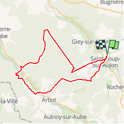
Randonnée V.T.T. de 31 km à découvrir à Grand Est, Haute-Marne, Saint-Loup-sur-Aujon. Cette randonnée est proposée par PhilippeC54.

Profil altimétrique

Localisation

Pays :
France
Région :
Grand Est
Département/Province :
Haute-Marne
Commune :
Saint-Loup-sur-Aujon
Localité :
Unknown
Départ:(Dec)
Départ:(UTM)
656437 ; 5306481 (31T) N.

Commentaires

Veuillez vous connecter pour laisser un commentaire ou une note


Randonnées à proximité

Randonnée V.T.T. Saint-Loup-sur-Aujon - Le Signal de Saint - Loup  sur Aujon - Photo
V.T.T.
tracegps

V.T.T.

Moyen
Saint-Loup-sur-Aujon, Grand Est, Haute-Marne, France
10,1 km | 12,9 km-effort
1h 0min
Oui
Randonnée Marche Saint-Loup-sur-Aujon - Le Signal de Saint - Loup  sur Aujon - Photo
Marche
tracegps

Marche

Moyen
Saint-Loup-sur-Aujon, Grand Est, Haute-Marne, France
10,1 km | 12,9 km-effort
2h 0min
Oui
Randonnée V.T.T. Saint-Loup-sur-Aujon - EC - P2-A Auberive - Photo
V.T.T.
PhilippeC54

V.T.T.

Très facile
Saint-Loup-sur-Aujon, Grand Est, Haute-Marne, France
21 km | 26 km-effort
1h 43min
Oui
Randonnée V.T.T. Saint-Loup-sur-Aujon - EC - P2 Auberive - Photo
V.T.T.
PhilippeC54

V.T.T.

Très facile
Saint-Loup-sur-Aujon, Grand Est, Haute-Marne, France
40 km | 49 km-effort
3h 10min
Oui
Randonnée V.T.T. Saint-Loup-sur-Aujon - EC - P1 Arc-en-Barrois - Photo
V.T.T.
PhilippeC54

V.T.T.

Très facile
Saint-Loup-sur-Aujon, Grand Est, Haute-Marne, France
25 km | 30 km-effort
1h 57min
Oui
Randonnée Vélo de route Saint-Loup-sur-Aujon - Courcelles samedi 27/5 - Photo
Vélo de route
René Kovac

Vélo de route

Saint-Loup-sur-Aujon, Grand Est, Haute-Marne, France
54 km | 63 km-effort
4h 15min
Oui
Randonnée Marche nordique Saint-Loup-sur-Aujon - 16 km Courcelles sur Aujon  - Photo
Marche nordique
avier

Marche nordique

Difficile
Saint-Loup-sur-Aujon, Grand Est, Haute-Marne, France
16,9 km | 22 km-effort
3h 32min
Oui
Randonnée Marche nordique Saint-Loup-sur-Aujon - 20 km Courcelles sur Aujon  - Photo
Marche nordique
avier

Marche nordique

Difficile
Saint-Loup-sur-Aujon, Grand Est, Haute-Marne, France
22 km | 28 km-effort
4h 20min
Oui
Randonnée Marche nordique Saint-Loup-sur-Aujon - 5 km Courcelles sur Aujon  - Photo
Marche nordique
avier

Marche nordique

Très facile
Saint-Loup-sur-Aujon, Grand Est, Haute-Marne, France
4,9 km | 5,9 km-effort
1h 0min
Oui


Fermer
Mes abonnements