![](/images/other/stat-length.png)
![Randonnée Marche Ensuès-la-Redonne - La chapelle notre Dame du Rouet. - Photo](https://media.geolcdn.com/t/1900/400/ext.pjpeg?maxdim=2&url=https%3A%2F%2Fservices.sitytrail.com%2FGeolivesWS%2FDownloadMedia.ashx%3FTrailID%3D901778%26Media%3Dfix__20180208144222.jpg)
La chapelle notre Dame du Rouet.
liocol
Utilisateur
![Longueur](/images/other/stat-length.png)
Longueur
13 km
![Altitude max](https://static1.geolcdn.com/siteimages/upload/files/1508320355ic_sort_altitude_max_24dp.png)
Altitude max
168 m
![Dénivelé positif](https://static1.geolcdn.com/siteimages/upload/files/1508320355ic_sort_den_pos_24dp.png)
Dénivelé positif
307 m
![Km-Effort](/images/other/stat-length.png)
Km-Effort
17,1 km
![Altitude min](https://static1.geolcdn.com/siteimages/upload/files/1508320355ic_sort_altitude_min_24dp.png)
Altitude min
1 m
![Dénivelé négatif](https://static1.geolcdn.com/siteimages/upload/files/1508320355ic_sort_den_neg_24dp.png)
Dénivelé négatif
305 m
![Boucle](https://static1.geolcdn.com/siteimages/upload/files/16400158638029165_repeat_loop_refresh_sync_direction_icon.png)
Boucle
Oui
Date de création :
2018-04-17 18:10:31.433
Dernière modification :
2018-04-17 18:10:31.433
![Marche](https://static1.geolcdn.com/sitytour/trail-icons/101.png)
3h41
Difficulté : Facile
![Scannez ce code QR pour ouvrir la randonnée dans l'application SityTrail](https://capi.geolives.com/qq0zvz2zws4bq2lad0pu/sitytour/trails/901778/qr.png?size=200)
Application GPS de randonnée GRATUITE
À propos
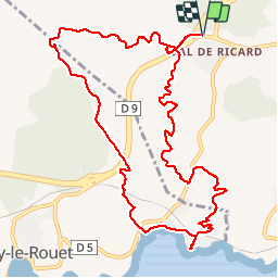
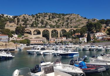
Randonnée Marche de 13 km à découvrir à Provence-Alpes-Côte d'Azur, Bouches-du-Rhône, Ensuès-la-Redonne. Cette randonnée est proposée par liocol.
Description
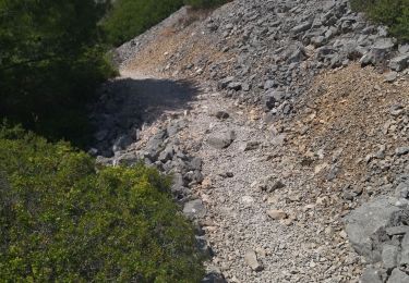
Quelques places pour stationner au départ, le long de la bretelle avant la 4 voies ( D9 ). Boucle de 13 Kms sans difficultés particulières.
Points d'intérêt
Localisation
Pays :
France
Région :
Provence-Alpes-Côte d'Azur
Département/Province :
Bouches-du-Rhône
Commune :
Ensuès-la-Redonne
Localité :
Unknown
Départ:(Dec)
Départ:(UTM)
676789 ; 4802735 (31T) N.
Commentaires
Randonnées à proximité
![Randonnée A pied Carry-le-Rouet - Le Vallon de Jaume par les Grottes - Photo](https://media.geolcdn.com/t/375/260/ext.jpg?maxdim=2&url=https%3A%2F%2Fmedia.geolcdn.com%2Ff%2F0b2898cd-0732-4408-b545-ff0a18859a39.jpeg)
![A pied A pied](https://static1.geolcdn.com/sitytour/trail-icons/100.png)
Le Vallon de Jaume par les Grottes
A pied
Facile
Carry-le-Rouet,
Provence-Alpes-Côte d'Azur,
Bouches-du-Rhône,
France
![](/images/other/stat-length.png)
7,5 km | 10,2 km-effort
2h 19min
![](https://static1.geolcdn.com/siteimages/upload/files/16400158638029165_repeat_loop_refresh_sync_direction_icon.png)
Non
![Randonnée A pied Carry-le-Rouet - Le Tour du Romaron - Photo](https://media.geolcdn.com/t/375/260/ext.jpg?maxdim=2&url=https%3A%2F%2Fmedia.geolcdn.com%2Ff%2F1a32f56d-69e4-4cf2-b186-82726e0bad5b.jpeg)
![A pied A pied](https://static1.geolcdn.com/sitytour/trail-icons/100.png)
Le Tour du Romaron
A pied
Facile
Carry-le-Rouet,
Provence-Alpes-Côte d'Azur,
Bouches-du-Rhône,
France
![](/images/other/stat-length.png)
7,3 km | 10 km-effort
2h 15min
![](https://static1.geolcdn.com/siteimages/upload/files/16400158638029165_repeat_loop_refresh_sync_direction_icon.png)
Non
![Randonnée A pied Carry-le-Rouet - Entre calanques et collines - Photo](https://media.geolcdn.com/t/375/260/ext.jpg?maxdim=2&url=https%3A%2F%2Fmedia.geolcdn.com%2Ff%2F1a32f56d-69e4-4cf2-b186-82726e0bad5b.jpeg)
![A pied A pied](https://static1.geolcdn.com/sitytour/trail-icons/100.png)
Entre calanques et collines
A pied
Facile
Carry-le-Rouet,
Provence-Alpes-Côte d'Azur,
Bouches-du-Rhône,
France
![](/images/other/stat-length.png)
11,8 km | 14,6 km-effort
3h 19min
![](https://static1.geolcdn.com/siteimages/upload/files/16400158638029165_repeat_loop_refresh_sync_direction_icon.png)
Non
![Randonnée A pied Ensuès-la-Redonne - Grand Sentier de la Côte Bleue - Photo](https://media.geolcdn.com/t/375/260/ext.jpg?maxdim=2&url=https%3A%2F%2Fmedia.geolcdn.com%2Ff%2Fe6d2f765-bb75-419b-b14b-35c0d85ab7e2.jpeg)
![A pied A pied](https://static1.geolcdn.com/sitytour/trail-icons/100.png)
Grand Sentier de la Côte Bleue
A pied
Très difficile
Ensuès-la-Redonne,
Provence-Alpes-Côte d'Azur,
Bouches-du-Rhône,
France
![](/images/other/stat-length.png)
50 km | 60 km-effort
13h 34min
![](https://static1.geolcdn.com/siteimages/upload/files/16400158638029165_repeat_loop_refresh_sync_direction_icon.png)
Non
![Randonnée Marche Ensuès-la-Redonne - La Redonne - Calanques des Anthénors et de Figuières - Photo](https://media.geolcdn.com/t/375/260/ext.jpg?maxdim=2&url=https%3A%2F%2Fmedia.geolcdn.com%2Ff%2F8a6fb41f-97ad-44cb-8c06-9a4b2c8de457.jpg)
![Marche Marche](https://static1.geolcdn.com/sitytour/trail-icons/101.png)
La Redonne - Calanques des Anthénors et de Figuières
Marche
Moyen
Ensuès-la-Redonne,
Provence-Alpes-Côte d'Azur,
Bouches-du-Rhône,
France
![](/images/other/stat-length.png)
4,6 km | 6,7 km-effort
1h 46min
![](https://static1.geolcdn.com/siteimages/upload/files/16400158638029165_repeat_loop_refresh_sync_direction_icon.png)
Oui
![Randonnée Marche Carry-le-Rouet - L'Estaque - Le Sentier du Lézard - Photo](https://media.geolcdn.com/t/375/260/ext.jpg?maxdim=2&url=https%3A%2F%2Fmedia.geolcdn.com%2Ff%2F5c48ce05-c987-4dd3-ba21-a19c1b71e8fe.jpg)
![Marche Marche](https://static1.geolcdn.com/sitytour/trail-icons/101.png)
L'Estaque - Le Sentier du Lézard
Marche
Facile
Carry-le-Rouet,
Provence-Alpes-Côte d'Azur,
Bouches-du-Rhône,
France
![](/images/other/stat-length.png)
4,9 km | 5,7 km-effort
1h 24min
![](https://static1.geolcdn.com/siteimages/upload/files/16400158638029165_repeat_loop_refresh_sync_direction_icon.png)
Oui
![Randonnée Marche Ensuès-la-Redonne - laRedonne le grand Méjan - Photo](https://media.geolcdn.com/t/375/260/ext.jpg?maxdim=2&url=https%3A%2F%2Fmedia.geolcdn.com%2Ff%2F7a6cd11d-21b3-489a-b0eb-328fab0c5232.jpg)
![Marche Marche](https://static1.geolcdn.com/sitytour/trail-icons/101.png)
laRedonne le grand Méjan
Marche
Moyen
Ensuès-la-Redonne,
Provence-Alpes-Côte d'Azur,
Bouches-du-Rhône,
France
![](/images/other/stat-length.png)
7,6 km | 11 km-effort
4h 5min
![](https://static1.geolcdn.com/siteimages/upload/files/16400158638029165_repeat_loop_refresh_sync_direction_icon.png)
Oui
![Randonnée Marche Ensuès-la-Redonne - Ensuez la redonne vers Niolon - Photo](https://media.geolcdn.com/t/375/260/ext.jpg?maxdim=2&url=https%3A%2F%2Fmedia.geolcdn.com%2Ff%2Fcddffefb-0e5e-48c1-8af0-c2f6ba46e7ae.JPG)
![Marche Marche](https://static1.geolcdn.com/sitytour/trail-icons/101.png)
Ensuez la redonne vers Niolon
Marche
Moyen
Ensuès-la-Redonne,
Provence-Alpes-Côte d'Azur,
Bouches-du-Rhône,
France
![](/images/other/stat-length.png)
6,8 km | 10 km-effort
2h 16min
![](https://static1.geolcdn.com/siteimages/upload/files/16400158638029165_repeat_loop_refresh_sync_direction_icon.png)
Non
![Randonnée Marche Carry-le-Rouet - Chemin des douaniers. Carry-le-Rouet à Niolon - Photo](https://media.geolcdn.com/t/375/260/ext.jpg?maxdim=2&url=https%3A%2F%2Fmedia.geolcdn.com%2Ff%2Fb8e8dfc1-288c-49de-ab4f-cbd7d72011a8.jpg)
![Marche Marche](https://static1.geolcdn.com/sitytour/trail-icons/101.png)
Chemin des douaniers. Carry-le-Rouet à Niolon
Marche
Moyen
Carry-le-Rouet,
Provence-Alpes-Côte d'Azur,
Bouches-du-Rhône,
France
![](/images/other/stat-length.png)
29 km | 40 km-effort
5h 31min
![](https://static1.geolcdn.com/siteimages/upload/files/16400158638029165_repeat_loop_refresh_sync_direction_icon.png)
Non