![](/images/other/stat-length.png)
![Randonnée Raquettes à neige Metzeral - Sans titre - Photo](https://media.geolcdn.com/t/1900/400/ext.pjpeg?maxdim=2&url=https%3A%2F%2Fstatic1.geolcdn.com%2Fsiteimages%2Fupload%2Ffiles%2F1524743153raquette.jpg)
Sans titre
markrei
Utilisateur
![Longueur](/images/other/stat-length.png)
Longueur
17,9 km
![Altitude max](https://static1.geolcdn.com/siteimages/upload/files/1508320355ic_sort_altitude_max_24dp.png)
Altitude max
1307 m
![Dénivelé positif](https://static1.geolcdn.com/siteimages/upload/files/1508320355ic_sort_den_pos_24dp.png)
Dénivelé positif
980 m
![Km-Effort](/images/other/stat-length.png)
Km-Effort
31 km
![Altitude min](https://static1.geolcdn.com/siteimages/upload/files/1508320355ic_sort_altitude_min_24dp.png)
Altitude min
656 m
![Dénivelé négatif](https://static1.geolcdn.com/siteimages/upload/files/1508320355ic_sort_den_neg_24dp.png)
Dénivelé négatif
982 m
![Boucle](https://static1.geolcdn.com/siteimages/upload/files/16400158638029165_repeat_loop_refresh_sync_direction_icon.png)
Boucle
Oui
Date de création :
2018-04-17 17:11:28.153
Dernière modification :
2018-04-17 17:11:28.153
![Raquettes à neige](https://static1.geolcdn.com/sitytour/trail-icons/504.png)
7h25
Difficulté : Moyen
![Scannez ce code QR pour ouvrir la randonnée dans l'application SityTrail](https://capi.geolives.com/qq0zvz2zws4bq2lad0pu/sitytour/trails/895440/qr.png?size=200)
Application GPS de randonnée GRATUITE
À propos
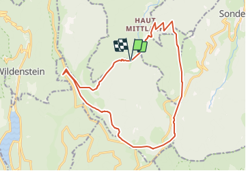
Randonnée Raquettes à neige de 17,9 km à découvrir à Grand Est, Haut-Rhin, Metzeral. Cette randonnée est proposée par markrei.
Description
Mittlach Le Haut - Le Schweisel - Refuge Huss - Refuge du Hahnebrunnen - Le Lauchenkopf - Schnefenriedkopf - Mittlach Le Haut
Localisation
Pays :
France
Région :
Grand Est
Département/Province :
Haut-Rhin
Commune :
Metzeral
Localité :
Unknown
Départ:(Dec)
Départ:(UTM)
352051 ; 5316138 (32T) N.
Commentaires
Randonnées à proximité
![Randonnée Marche La Bresse - 2023-04-16 Marche Abri Lac de Blanchemer vers Lac de Lispach - Photo](https://media.geolcdn.com/t/375/260/20b642e6-a3a8-4790-bc8e-b2ad298c0408.jpg&format=jpg&maxdim=2)
![Marche Marche](https://static1.geolcdn.com/sitytour/trail-icons/101.png)
2023-04-16 Marche Abri Lac de Blanchemer vers Lac de Lispach
Marche
Très difficile
(1)
La Bresse,
Grand Est,
Vosges,
France
![](/images/other/stat-length.png)
23 km | 36 km-effort
8h 4min
![](https://static1.geolcdn.com/siteimages/upload/files/16400158638029165_repeat_loop_refresh_sync_direction_icon.png)
Non
![Randonnée Marche Wildenstein - 2022-02-20 Marche Kruth Grand Ventron - Photo](https://media.geolcdn.com/t/375/260/74324e84-ba09-479c-87ba-50417488039d.jpg&format=jpg&maxdim=2)
![Marche Marche](https://static1.geolcdn.com/sitytour/trail-icons/101.png)
2022-02-20 Marche Kruth Grand Ventron
Marche
Très difficile
(1)
Wildenstein,
Grand Est,
Haut-Rhin,
France
![](/images/other/stat-length.png)
16,8 km | 27 km-effort
4h 52min
![](https://static1.geolcdn.com/siteimages/upload/files/16400158638029165_repeat_loop_refresh_sync_direction_icon.png)
Oui
![Randonnée Marche Kruth - Autour du lac de Kruth-Wildenstein - Photo](https://media.geolcdn.com/t/375/260/c1e79833-f011-4190-a625-acd1b44dc0b0.jpeg&format=jpg&maxdim=2)
![Marche Marche](https://static1.geolcdn.com/sitytour/trail-icons/101.png)
Autour du lac de Kruth-Wildenstein
Marche
Moyen
(1)
Kruth,
Grand Est,
Haut-Rhin,
France
![](/images/other/stat-length.png)
7,6 km | 12,7 km-effort
3h 15min
![](https://static1.geolcdn.com/siteimages/upload/files/16400158638029165_repeat_loop_refresh_sync_direction_icon.png)
Oui
![Randonnée Marche La Bresse - Kastelberg des pierres, des lacs, des panoramas magnifiques - Photo](https://media.geolcdn.com/t/375/260/cada329c-fae7-4d3f-815e-38ed5d6ce361.jpg&format=jpg&maxdim=2)
![Marche Marche](https://static1.geolcdn.com/sitytour/trail-icons/101.png)
Kastelberg des pierres, des lacs, des panoramas magnifiques
Marche
Difficile
(1)
La Bresse,
Grand Est,
Vosges,
France
![](/images/other/stat-length.png)
15,1 km | 26 km-effort
6h 11min
![](https://static1.geolcdn.com/siteimages/upload/files/16400158638029165_repeat_loop_refresh_sync_direction_icon.png)
Oui
![Randonnée Marche Wildenstein - TREK ALSACIEN (boucle de Wildenstein) - Photo](https://media.geolcdn.com/t/375/260/319755c6-b355-43a3-9980-ff414aa67ddf.jpg&format=jpg&maxdim=2)
![Marche Marche](https://static1.geolcdn.com/sitytour/trail-icons/101.png)
TREK ALSACIEN (boucle de Wildenstein)
Marche
Difficile
(1)
Wildenstein,
Grand Est,
Haut-Rhin,
France
![](/images/other/stat-length.png)
15,4 km | 24 km-effort
5h 20min
![](https://static1.geolcdn.com/siteimages/upload/files/16400158638029165_repeat_loop_refresh_sync_direction_icon.png)
Oui
![Randonnée Marche La Bresse - Rainkopf - Mittlach - Hohneck - Photo](https://media.geolcdn.com/t/375/260/ext.jpg?maxdim=2&url=https%3A%2F%2Fservices.sitytrail.com%2FGeolivesWS%2FDownloadMedia.ashx%3FTrailID%3D105669%26Media%3D9489_5.jpg)
![Marche Marche](https://static1.geolcdn.com/sitytour/trail-icons/101.png)
Rainkopf - Mittlach - Hohneck
Marche
Difficile
(1)
La Bresse,
Grand Est,
Vosges,
France
![](/images/other/stat-length.png)
22 km | 41 km-effort
8h 0min
![](https://static1.geolcdn.com/siteimages/upload/files/16400158638029165_repeat_loop_refresh_sync_direction_icon.png)
Oui
![Randonnée V.T.T. Metzeral - Tour du Gaschney par le Sattel - Photo](https://media.geolcdn.com/t/375/260/b4105d0c-3aa2-477c-bf30-5182d0c48680.jpg&format=jpg&maxdim=2)
![V.T.T. V.T.T.](https://static1.geolcdn.com/sitytour/trail-icons/202.png)
Tour du Gaschney par le Sattel
V.T.T.
Difficile
(1)
Metzeral,
Grand Est,
Haut-Rhin,
France
![](/images/other/stat-length.png)
25 km | 37 km-effort
2h 32min
![](https://static1.geolcdn.com/siteimages/upload/files/16400158638029165_repeat_loop_refresh_sync_direction_icon.png)
Oui
![Randonnée V.T.T. Metzeral - Sentier des Névés - Photo](https://media.geolcdn.com/t/375/260/ext.jpg?maxdim=2&url=https%3A%2F%2Fservices.sitytrail.com%2FGeolivesWS%2FDownloadMedia.ashx%3FTrailID%3D100801%26Media%3D308_1.jpg)
![V.T.T. V.T.T.](https://static1.geolcdn.com/sitytour/trail-icons/202.png)
Sentier des Névés
V.T.T.
Très difficile
(1)
Metzeral,
Grand Est,
Haut-Rhin,
France
![](/images/other/stat-length.png)
33 km | 52 km-effort
6h 0min
![](https://static1.geolcdn.com/siteimages/upload/files/16400158638029165_repeat_loop_refresh_sync_direction_icon.png)
Oui
![Randonnée Marche Mittlach - 2023-09-24 Marche Mittlach 5 Lacs - Photo](https://media.geolcdn.com/t/375/260/3a2b1bda-6de8-40f1-aeb6-067a05e29c55.jpg&format=jpg&maxdim=2)
![Marche Marche](https://static1.geolcdn.com/sitytour/trail-icons/101.png)
2023-09-24 Marche Mittlach 5 Lacs
Marche
Moyen
Mittlach,
Grand Est,
Haut-Rhin,
France
![](/images/other/stat-length.png)
25 km | 41 km-effort
9h 19min
![](https://static1.geolcdn.com/siteimages/upload/files/16400158638029165_repeat_loop_refresh_sync_direction_icon.png)
Oui