![](/images/other/stat-length.png)
![Randonnée Marche Bouère - De Bouère à St-Brice - Photo](https://media.geolcdn.com/t/1900/400/ext.pjpeg?maxdim=2&url=https%3A%2F%2Fstatic1.geolcdn.com%2Fsiteimages%2Fupload%2Ffiles%2F1553511878bg_sport_marche.png)
De Bouère à St-Brice
neoroll44
Utilisateur
![Longueur](/images/other/stat-length.png)
Longueur
13 km
![Altitude max](https://static1.geolcdn.com/siteimages/upload/files/1508320355ic_sort_altitude_max_24dp.png)
Altitude max
83 m
![Dénivelé positif](https://static1.geolcdn.com/siteimages/upload/files/1508320355ic_sort_den_pos_24dp.png)
Dénivelé positif
142 m
![Km-Effort](/images/other/stat-length.png)
Km-Effort
14,9 km
![Altitude min](https://static1.geolcdn.com/siteimages/upload/files/1508320355ic_sort_altitude_min_24dp.png)
Altitude min
46 m
![Dénivelé négatif](https://static1.geolcdn.com/siteimages/upload/files/1508320355ic_sort_den_neg_24dp.png)
Dénivelé négatif
143 m
![Boucle](https://static1.geolcdn.com/siteimages/upload/files/16400158638029165_repeat_loop_refresh_sync_direction_icon.png)
Boucle
Oui
Date de création :
2018-04-17 16:59:16.576
Dernière modification :
2018-04-17 16:59:16.576
![Marche](https://static1.geolcdn.com/sitytour/trail-icons/101.png)
3h15
Difficulté : Moyen
![Scannez ce code QR pour ouvrir la randonnée dans l'application SityTrail](https://capi.geolives.com/qq0zvz2zws4bq2lad0pu/sitytour/trails/893860/qr.png?size=200)
Application GPS de randonnée GRATUITE
À propos
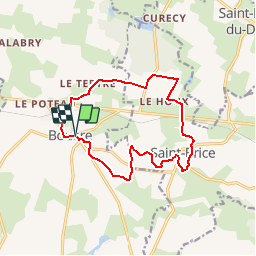
Randonnée Marche de 13 km à découvrir à Pays de la Loire, Mayenne, Bouère. Cette randonnée est proposée par neoroll44.
Description
Non loin de la forêt de Bellebranche.
De l'église, prendre le CD 14 vers Grez en Bouère, puis à droite vers la croix verte.
Puis le Moulin Neuf, Manchetière, près de Bellebranche et retour par St-Brice et le plan d'eau.
Localisation
Pays :
France
Région :
Pays de la Loire
Département/Province :
Mayenne
Commune :
Bouère
Localité :
Unknown
Départ:(Dec)
Départ:(UTM)
688652 ; 5304229 (30T) N.
Commentaires
Randonnées à proximité
![Randonnée Marche Bouère - Bouère. Circuit N4 - Photo](https://media.geolcdn.com/t/375/260/ext.jpg?maxdim=2&url=https%3A%2F%2Fstatic1.geolcdn.com%2Fsiteimages%2Fupload%2Ffiles%2F1553511878bg_sport_marche.png)
![Marche Marche](https://static1.geolcdn.com/sitytour/trail-icons/101.png)
Bouère. Circuit N4
Marche
Facile
(1)
Bouère,
Pays de la Loire,
Mayenne,
France
![](/images/other/stat-length.png)
4,5 km | 5,4 km-effort
1h 38min
![](https://static1.geolcdn.com/siteimages/upload/files/16400158638029165_repeat_loop_refresh_sync_direction_icon.png)
Oui
![Randonnée Marche Grez-en-Bouère - Grez en Bouère - Photo](https://media.geolcdn.com/t/375/260/ext.jpg?maxdim=2&url=https%3A%2F%2Fstatic1.geolcdn.com%2Fsiteimages%2Fupload%2Ffiles%2F1553511878bg_sport_marche.png)
![Marche Marche](https://static1.geolcdn.com/sitytour/trail-icons/101.png)
Grez en Bouère
Marche
Moyen
Grez-en-Bouère,
Pays de la Loire,
Mayenne,
France
![](/images/other/stat-length.png)
12,8 km | 14,8 km-effort
3h 20min
![](https://static1.geolcdn.com/siteimages/upload/files/16400158638029165_repeat_loop_refresh_sync_direction_icon.png)
Oui
![Randonnée Marche Saint-Brice - 2024 06 02 bellebranche - Photo](https://media.geolcdn.com/t/375/260/ext.jpg?maxdim=2&url=https%3A%2F%2Fstatic1.geolcdn.com%2Fsiteimages%2Fupload%2Ffiles%2F1553511878bg_sport_marche.png)
![Marche Marche](https://static1.geolcdn.com/sitytour/trail-icons/101.png)
2024 06 02 bellebranche
Marche
Facile
Saint-Brice,
Pays de la Loire,
Mayenne,
France
![](/images/other/stat-length.png)
9 km | 10,4 km-effort
1h 59min
![](https://static1.geolcdn.com/siteimages/upload/files/16400158638029165_repeat_loop_refresh_sync_direction_icon.png)
Oui
![Randonnée Geocaching Saint-Loup-du-Dorat - Labyrinthe Alice Juillet 2022 - Photo](https://media.geolcdn.com/t/375/260/ext.jpg?maxdim=2&url=https%3A%2F%2Fstatic1.geolcdn.com%2Fsiteimages%2Fupload%2Ffiles%2F1545311037marcheuse_200dpi.jpg)
![Geocaching Geocaching](https://static1.geolcdn.com/sitytour/trail-icons/908.png)
Labyrinthe Alice Juillet 2022
Geocaching
Moyen
Saint-Loup-du-Dorat,
Pays de la Loire,
Mayenne,
France
![](/images/other/stat-length.png)
11,8 km | 13,1 km-effort
2h 50min
![](https://static1.geolcdn.com/siteimages/upload/files/16400158638029165_repeat_loop_refresh_sync_direction_icon.png)
Non
![Randonnée Marche Bouère - de Bouère à Grez - Photo](https://media.geolcdn.com/t/375/260/ext.jpg?maxdim=2&url=https%3A%2F%2Fstatic1.geolcdn.com%2Fsiteimages%2Fupload%2Ffiles%2F1553511878bg_sport_marche.png)
![Marche Marche](https://static1.geolcdn.com/sitytour/trail-icons/101.png)
de Bouère à Grez
Marche
Très facile
Bouère,
Pays de la Loire,
Mayenne,
France
![](/images/other/stat-length.png)
14,4 km | 16,6 km-effort
3h 55min
![](https://static1.geolcdn.com/siteimages/upload/files/16400158638029165_repeat_loop_refresh_sync_direction_icon.png)
Oui
![Randonnée Marche Bouère - Bouère. autour du village - Photo](https://media.geolcdn.com/t/375/260/ext.jpg?maxdim=2&url=https%3A%2F%2Fstatic1.geolcdn.com%2Fsiteimages%2Fupload%2Ffiles%2F1553511878bg_sport_marche.png)
![Marche Marche](https://static1.geolcdn.com/sitytour/trail-icons/101.png)
Bouère. autour du village
Marche
Moyen
Bouère,
Pays de la Loire,
Mayenne,
France
![](/images/other/stat-length.png)
11,4 km | 13,1 km-effort
3h 5min
![](https://static1.geolcdn.com/siteimages/upload/files/16400158638029165_repeat_loop_refresh_sync_direction_icon.png)
Oui
![Randonnée Marche Saint-Brice - Saint-Brice Marche à pied, forêt de Bellebranche - Photo](https://media.geolcdn.com/t/375/260/ext.jpg?maxdim=2&url=https%3A%2F%2Fstatic1.geolcdn.com%2Fsiteimages%2Fupload%2Ffiles%2F1553511878bg_sport_marche.png)
![Marche Marche](https://static1.geolcdn.com/sitytour/trail-icons/101.png)
Saint-Brice Marche à pied, forêt de Bellebranche
Marche
Moyen
Saint-Brice,
Pays de la Loire,
Mayenne,
France
![](/images/other/stat-length.png)
9,2 km | 10,6 km-effort
2h 19min
![](https://static1.geolcdn.com/siteimages/upload/files/16400158638029165_repeat_loop_refresh_sync_direction_icon.png)
Oui