![](/images/other/stat-length.png)
![Randonnée Marche Saint-Lothain - EC4_St Lothain-Château Chalon - Photo](https://media.geolcdn.com/t/1900/400/ext.pjpeg?maxdim=2&url=https%3A%2F%2Fstatic1.geolcdn.com%2Fsiteimages%2Fupload%2Ffiles%2F1553511878bg_sport_marche.png)
EC4_St Lothain-Château Chalon
bernard54
Utilisateur
![Longueur](/images/other/stat-length.png)
Longueur
12,1 km
![Altitude max](https://static1.geolcdn.com/siteimages/upload/files/1508320355ic_sort_altitude_max_24dp.png)
Altitude max
493 m
![Dénivelé positif](https://static1.geolcdn.com/siteimages/upload/files/1508320355ic_sort_den_pos_24dp.png)
Dénivelé positif
472 m
![Km-Effort](/images/other/stat-length.png)
Km-Effort
18,1 km
![Altitude min](https://static1.geolcdn.com/siteimages/upload/files/1508320355ic_sort_altitude_min_24dp.png)
Altitude min
326 m
![Dénivelé négatif](https://static1.geolcdn.com/siteimages/upload/files/1508320355ic_sort_den_neg_24dp.png)
Dénivelé négatif
405 m
![Boucle](https://static1.geolcdn.com/siteimages/upload/files/16400158638029165_repeat_loop_refresh_sync_direction_icon.png)
Boucle
Non
Date de création :
2018-04-17 16:56:20.182
Dernière modification :
2018-04-17 16:56:20.182
![Marche](https://static1.geolcdn.com/sitytour/trail-icons/101.png)
3h54
Difficulté : Difficile
![Scannez ce code QR pour ouvrir la randonnée dans l'application SityTrail](https://capi.geolives.com/qq0zvz2zws4bq2lad0pu/sitytour/trails/893410/qr.png?size=200)
Application GPS de randonnée GRATUITE
À propos
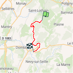
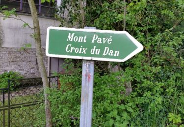
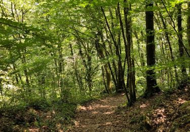
Randonnée Marche de 12,1 km à découvrir à Bourgogne-Franche-Comté, Jura, Saint-Lothain. Cette randonnée est proposée par bernard54.
Description
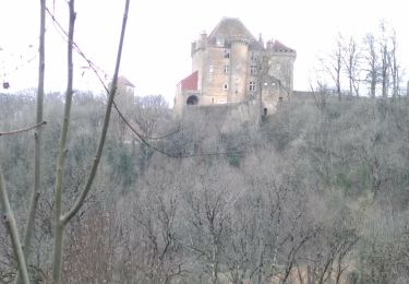
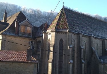
Échappée Jurassienne Etape 4 St Lothain - Château Chalon Chambre d'hôte et Gîte T'nature 1 rue de l'église 39210 Château Chalon 06 30 53 30 82
Localisation
Pays :
France
Région :
Bourgogne-Franche-Comté
Département/Province :
Jura
Commune :
Saint-Lothain
Localité :
Unknown
Départ:(Dec)
Départ:(UTM)
701886 ; 5187077 (31T) N.
Commentaires
Randonnées à proximité
![Randonnée Marche Domblans - Domblans 17 km D+ 527m 20191002 - Photo](https://media.geolcdn.com/t/375/260/ext.jpg?maxdim=2&url=https%3A%2F%2Fstatic1.geolcdn.com%2Fsiteimages%2Fupload%2Ffiles%2F1553511878bg_sport_marche.png)
![Marche Marche](https://static1.geolcdn.com/sitytour/trail-icons/101.png)
Domblans 17 km D+ 527m 20191002
Marche
Très difficile
(1)
Domblans,
Bourgogne-Franche-Comté,
Jura,
France
![](/images/other/stat-length.png)
16,9 km | 24 km-effort
5h 2min
![](https://static1.geolcdn.com/siteimages/upload/files/16400158638029165_repeat_loop_refresh_sync_direction_icon.png)
Oui
![Randonnée Marche Poligny - Poligny - Photo](https://media.geolcdn.com/t/375/260/88260447-48bb-4aa1-923f-4a444da24056.jpg&format=jpg&maxdim=2)
![Marche Marche](https://static1.geolcdn.com/sitytour/trail-icons/101.png)
![Randonnée Marche Domblans - Domblans - Frontenay - Château Chalon - Photo](https://media.geolcdn.com/t/375/260/ext.jpg?maxdim=2&url=https%3A%2F%2Fstatic1.geolcdn.com%2Fsiteimages%2Fupload%2Ffiles%2F1553511878bg_sport_marche.png)
![Marche Marche](https://static1.geolcdn.com/sitytour/trail-icons/101.png)
Domblans - Frontenay - Château Chalon
Marche
Très difficile
(1)
Domblans,
Bourgogne-Franche-Comté,
Jura,
France
![](/images/other/stat-length.png)
17,2 km | 23 km-effort
5h 16min
![](https://static1.geolcdn.com/siteimages/upload/files/16400158638029165_repeat_loop_refresh_sync_direction_icon.png)
Oui
![Randonnée Marche Saint-Lothain - Saint Lothain Fontenay 04 mars 2021 (IBP 73) CAF - Photo](https://media.geolcdn.com/t/375/260/46557cd5-7027-4fbc-92c9-d18f0a45ba79.jpg&format=jpg&maxdim=2)
![Marche Marche](https://static1.geolcdn.com/sitytour/trail-icons/101.png)
Saint Lothain Fontenay 04 mars 2021 (IBP 73) CAF
Marche
Moyen
Saint-Lothain,
Bourgogne-Franche-Comté,
Jura,
France
![](/images/other/stat-length.png)
22 km | 30 km-effort
6h 2min
![](https://static1.geolcdn.com/siteimages/upload/files/16400158638029165_repeat_loop_refresh_sync_direction_icon.png)
Oui
![Randonnée Marche Menétru-le-Vignoble - Ménétru Blois sur Seilles Château Chalon 15 sept 2020CAF - Photo](https://media.geolcdn.com/t/375/260/9004b1e2-b6c6-403d-8aa0-f11cc5ff9113.jpg&format=jpg&maxdim=2)
![Marche Marche](https://static1.geolcdn.com/sitytour/trail-icons/101.png)
Ménétru Blois sur Seilles Château Chalon 15 sept 2020CAF
Marche
Difficile
Menétru-le-Vignoble,
Bourgogne-Franche-Comté,
Jura,
France
![](/images/other/stat-length.png)
23 km | 35 km-effort
5h 31min
![](https://static1.geolcdn.com/siteimages/upload/files/16400158638029165_repeat_loop_refresh_sync_direction_icon.png)
Oui
![Randonnée Marche Poligny - Poligny 15 km prj 20170609 - Photo](https://media.geolcdn.com/t/375/260/ext.jpg?maxdim=2&url=https%3A%2F%2Fservices.sitytrail.com%2FGeolivesWS%2FDownloadMedia.ashx%3FTrailID%3D769793%26Media%3Dfix__20160508183735.jpg)
![Marche Marche](https://static1.geolcdn.com/sitytour/trail-icons/101.png)
Poligny 15 km prj 20170609
Marche
Très facile
Poligny,
Bourgogne-Franche-Comté,
Jura,
France
![](/images/other/stat-length.png)
15 km | 23 km-effort
4h 57min
![](https://static1.geolcdn.com/siteimages/upload/files/16400158638029165_repeat_loop_refresh_sync_direction_icon.png)
Oui
![Randonnée Marche Poligny - Poligny 12.7 km 20160508 - Photo](https://media.geolcdn.com/t/375/260/ext.jpg?maxdim=2&url=https%3A%2F%2Fservices.sitytrail.com%2FGeolivesWS%2FDownloadMedia.ashx%3FTrailID%3D565986%26Media%3Dfix__20160508183735.jpg)
![Marche Marche](https://static1.geolcdn.com/sitytour/trail-icons/101.png)
Poligny 12.7 km 20160508
Marche
Très facile
(1)
Poligny,
Bourgogne-Franche-Comté,
Jura,
France
![](/images/other/stat-length.png)
12,7 km | 19,8 km-effort
4h 18min
![](https://static1.geolcdn.com/siteimages/upload/files/16400158638029165_repeat_loop_refresh_sync_direction_icon.png)
Oui
![Randonnée Marche Poligny - Croix du Dan - Photo](https://media.geolcdn.com/t/375/260/472b018a-a391-42de-94ee-d87f1bdafb2a.jpg&format=jpg&maxdim=2)
![Marche Marche](https://static1.geolcdn.com/sitytour/trail-icons/101.png)
Croix du Dan
Marche
Moyen
Poligny,
Bourgogne-Franche-Comté,
Jura,
France
![](/images/other/stat-length.png)
10,9 km | 17,4 km-effort
2h 52min
![](https://static1.geolcdn.com/siteimages/upload/files/16400158638029165_repeat_loop_refresh_sync_direction_icon.png)
Oui
![Randonnée Marche Saint-Lothain - Saint Lothain - Photo](https://media.geolcdn.com/t/375/260/24dc9fd7-5aaa-439c-a05f-0fc7570c951e.jpg&format=jpg&maxdim=2)
![Marche Marche](https://static1.geolcdn.com/sitytour/trail-icons/101.png)
Saint Lothain
Marche
Facile
Saint-Lothain,
Bourgogne-Franche-Comté,
Jura,
France
![](/images/other/stat-length.png)
19,6 km | 26 km-effort
5h 33min
![](https://static1.geolcdn.com/siteimages/upload/files/16400158638029165_repeat_loop_refresh_sync_direction_icon.png)
Oui