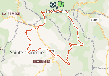
![](/images/other/stat-length.png)
![Randonnée Marche Montet-et-Bouxal - Ste Colombe - Moulin de Pétarot - Photo](https://media.geolcdn.com/t/1900/400/ext.pjpeg?maxdim=2&url=https%3A%2F%2Fstatic1.geolcdn.com%2Fsiteimages%2Fupload%2Ffiles%2F1553511878bg_sport_marche.png)
Ste Colombe - Moulin de Pétarot
goutal
Utilisateur
![Longueur](/images/other/stat-length.png)
Longueur
10,1 km
![Altitude max](https://static1.geolcdn.com/siteimages/upload/files/1508320355ic_sort_altitude_max_24dp.png)
Altitude max
614 m
![Dénivelé positif](https://static1.geolcdn.com/siteimages/upload/files/1508320355ic_sort_den_pos_24dp.png)
Dénivelé positif
243 m
![Km-Effort](/images/other/stat-length.png)
Km-Effort
13,3 km
![Altitude min](https://static1.geolcdn.com/siteimages/upload/files/1508320355ic_sort_altitude_min_24dp.png)
Altitude min
460 m
![Dénivelé négatif](https://static1.geolcdn.com/siteimages/upload/files/1508320355ic_sort_den_neg_24dp.png)
Dénivelé négatif
240 m
![Boucle](https://static1.geolcdn.com/siteimages/upload/files/16400158638029165_repeat_loop_refresh_sync_direction_icon.png)
Boucle
Oui
Date de création :
2018-04-17 15:49:31.312
Dernière modification :
2018-04-17 15:49:31.312
![Marche](https://static1.geolcdn.com/sitytour/trail-icons/101.png)
2h50
Difficulté : Facile
![Scannez ce code QR pour ouvrir la randonnée dans l'application SityTrail](https://capi.geolives.com/qq0zvz2zws4bq2lad0pu/sitytour/trails/885037/qr.png?size=200)
Application GPS de randonnée GRATUITE
À propos
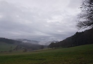
Randonnée Marche de 10,1 km à découvrir à Occitanie, Lot, Montet-et-Bouxal. Cette randonnée est proposée par goutal.
Description
Départ sur la pace de Lavitarele vers Rouqueyroux, Ste Colombe, Les Vergnes, Moulin de Pétarot e retour vers Lacompostie, Latreille et arrivée à Lavitarelle.
Localisation
Pays :
France
Région :
Occitanie
Département/Province :
Lot
Commune :
Montet-et-Bouxal
Localité :
Unknown
Départ:(Dec)
Départ:(UTM)
422333 ; 4954573 (31T) N.
Commentaires
Randonnées à proximité
![Randonnée Marche Terrou - Terrou2 - Photo](https://media.geolcdn.com/t/375/260/9092d809-fa6c-4224-851f-68804e61052c.jpg&format=jpg&maxdim=2)
![Marche Marche](https://static1.geolcdn.com/sitytour/trail-icons/101.png)
![Randonnée Marche Sabadel-Latronquière - gouffre dès cloches - Photo](https://media.geolcdn.com/t/375/260/b58c68f6-1574-424f-9ec5-78b7509ee53a.jpg&format=jpg&maxdim=2)
![Marche Marche](https://static1.geolcdn.com/sitytour/trail-icons/101.png)
gouffre dès cloches
Marche
Difficile
Sabadel-Latronquière,
Occitanie,
Lot,
France
![](/images/other/stat-length.png)
4,9 km | 7,2 km-effort
2h 35min
![](https://static1.geolcdn.com/siteimages/upload/files/16400158638029165_repeat_loop_refresh_sync_direction_icon.png)
Non
![Randonnée Marche Montet-et-Bouxal - la vitarelle - Photo](https://media.geolcdn.com/t/375/260/ext.jpg?maxdim=2&url=https%3A%2F%2Fstatic1.geolcdn.com%2Fsiteimages%2Fupload%2Ffiles%2F1553511878bg_sport_marche.png)
![Marche Marche](https://static1.geolcdn.com/sitytour/trail-icons/101.png)
la vitarelle
Marche
Très difficile
Montet-et-Bouxal,
Occitanie,
Lot,
France
![](/images/other/stat-length.png)
16 km | 22 km-effort
4h 17min
![](https://static1.geolcdn.com/siteimages/upload/files/16400158638029165_repeat_loop_refresh_sync_direction_icon.png)
Oui
![Randonnée Marche Saint-Perdoux - mines du Soulié - Photo](https://media.geolcdn.com/t/375/260/c808ca52-6e3d-4d10-a531-94b88c428f66.jpg&format=jpg&maxdim=2)
![Marche Marche](https://static1.geolcdn.com/sitytour/trail-icons/101.png)
mines du Soulié
Marche
Facile
Saint-Perdoux,
Occitanie,
Lot,
France
![](/images/other/stat-length.png)
2,8 km | 3,7 km-effort
45min
![](https://static1.geolcdn.com/siteimages/upload/files/16400158638029165_repeat_loop_refresh_sync_direction_icon.png)
Oui
![Randonnée Marche nordique Sabadel-Latronquière - monter et bouxal - Photo](https://media.geolcdn.com/t/375/260/0b478230-b093-4fea-974c-be519085b0ba.jpg&format=jpg&maxdim=2)
![Marche nordique Marche nordique](https://static1.geolcdn.com/sitytour/trail-icons/102.png)
monter et bouxal
Marche nordique
Moyen
Sabadel-Latronquière,
Occitanie,
Lot,
France
![](/images/other/stat-length.png)
14,4 km | 20 km-effort
3h 37min
![](https://static1.geolcdn.com/siteimages/upload/files/16400158638029165_repeat_loop_refresh_sync_direction_icon.png)
Oui
![Randonnée Vélo de route Sainte-Colombe - Rénac plage - Photo](https://media.geolcdn.com/t/375/260/ext.jpg?maxdim=2&url=https%3A%2F%2Fstatic1.geolcdn.com%2Fsiteimages%2Fupload%2Ffiles%2F1524743154velo.jpg)
![Vélo de route Vélo de route](https://static1.geolcdn.com/sitytour/trail-icons/201.png)
Rénac plage
Vélo de route
Très difficile
Sainte-Colombe,
Occitanie,
Lot,
France
![](/images/other/stat-length.png)
47 km | 58 km-effort
3h 19min
![](https://static1.geolcdn.com/siteimages/upload/files/16400158638029165_repeat_loop_refresh_sync_direction_icon.png)
Non
![Randonnée Marche Terrou - Terrou_6kms - Photo](https://media.geolcdn.com/t/375/260/ext.jpg?maxdim=2&url=https%3A%2F%2Fstatic1.geolcdn.com%2Fsiteimages%2Fupload%2Ffiles%2F1553511878bg_sport_marche.png)
![Marche Marche](https://static1.geolcdn.com/sitytour/trail-icons/101.png)
![Randonnée Marche Terrou - TERROU_TOLERME 14.4 km - Photo](https://media.geolcdn.com/t/375/260/ext.jpg?maxdim=2&url=https%3A%2F%2Fstatic1.geolcdn.com%2Fsiteimages%2Fupload%2Ffiles%2F1553511878bg_sport_marche.png)
![Marche Marche](https://static1.geolcdn.com/sitytour/trail-icons/101.png)
TERROU_TOLERME 14.4 km
Marche
Très difficile
Terrou,
Occitanie,
Lot,
France
![](/images/other/stat-length.png)
14,4 km | 20 km-effort
4h 23min
![](https://static1.geolcdn.com/siteimages/upload/files/16400158638029165_repeat_loop_refresh_sync_direction_icon.png)
Non
![Randonnée Marche Terrou - TERROU 9.1 km - Photo](https://media.geolcdn.com/t/375/260/ext.jpg?maxdim=2&url=https%3A%2F%2Fstatic1.geolcdn.com%2Fsiteimages%2Fupload%2Ffiles%2F1553511878bg_sport_marche.png)
![Marche Marche](https://static1.geolcdn.com/sitytour/trail-icons/101.png)