![](/images/other/stat-length.png)
![Randonnée Marche Bagnoles-de-l'Orne-Normandie - Bagnoles-Couterne aux confins de la Normandie - Photo](https://media.geolcdn.com/t/1900/400/ext.pjpeg?maxdim=2&url=https%3A%2F%2Fstatic1.geolcdn.com%2Fsiteimages%2Fupload%2Ffiles%2F1553511878bg_sport_marche.png)
Bagnoles-Couterne aux confins de la Normandie
toporient
Utilisateur
![Longueur](/images/other/stat-length.png)
Longueur
13,8 km
![Altitude max](https://static1.geolcdn.com/siteimages/upload/files/1508320355ic_sort_altitude_max_24dp.png)
Altitude max
229 m
![Dénivelé positif](https://static1.geolcdn.com/siteimages/upload/files/1508320355ic_sort_den_pos_24dp.png)
Dénivelé positif
233 m
![Km-Effort](/images/other/stat-length.png)
Km-Effort
16,9 km
![Altitude min](https://static1.geolcdn.com/siteimages/upload/files/1508320355ic_sort_altitude_min_24dp.png)
Altitude min
121 m
![Dénivelé négatif](https://static1.geolcdn.com/siteimages/upload/files/1508320355ic_sort_den_neg_24dp.png)
Dénivelé négatif
233 m
![Boucle](https://static1.geolcdn.com/siteimages/upload/files/16400158638029165_repeat_loop_refresh_sync_direction_icon.png)
Boucle
Oui
Date de création :
2018-04-17 14:57:18.246
Dernière modification :
2018-04-17 14:57:18.246
![Marche](https://static1.geolcdn.com/sitytour/trail-icons/101.png)
3h39
Difficulté : Moyen
![Scannez ce code QR pour ouvrir la randonnée dans l'application SityTrail](https://capi.geolives.com/qq0zvz2zws4bq2lad0pu/sitytour/trails/878271/qr.png?size=200)
Application GPS de randonnée GRATUITE
À propos
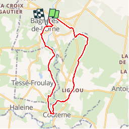
Randonnée Marche de 13,8 km à découvrir à Normandie, Orne, Bagnoles-de-l'Orne-Normandie. Cette randonnée est proposée par toporient.
Description
Du château, le circuit passe par le lac puis par le vieux Bagnoles. Il rejoint ensuite le GRP jusqu'à ND de Lignou et Couterne puis revient par la vallée de la Vée et le vieux Tessé pour terminer au château.
Localisation
Pays :
France
Région :
Normandie
Département/Province :
Orne
Commune :
Bagnoles-de-l'Orne-Normandie
Localité :
Bagnoles-de-l'Orne
Départ:(Dec)
Départ:(UTM)
690249 ; 5381036 (30U) N.
Commentaires
Randonnées à proximité
![Randonnée A pied Rives-d'Andaine - Sentier des Templiers - Photo](https://media.geolcdn.com/t/375/260/ext.jpg?maxdim=2&url=https%3A%2F%2Fmedia.geolcdn.com%2Ff%2F7f8f2913-590f-4c31-b4e9-64954dd46906.jpeg)
![A pied A pied](https://static1.geolcdn.com/sitytour/trail-icons/100.png)
Sentier des Templiers
A pied
Facile
Rives-d'Andaine,
Normandie,
Orne,
France
![](/images/other/stat-length.png)
4,9 km | 6,2 km-effort
1h 23min
![](https://static1.geolcdn.com/siteimages/upload/files/16400158638029165_repeat_loop_refresh_sync_direction_icon.png)
Non
![Randonnée Marche Bagnoles-de-l'Orne-Normandie - Saint Ortaire - Photo](https://media.geolcdn.com/t/375/260/ext.jpg?maxdim=2&url=https%3A%2F%2Fstatic1.geolcdn.com%2Fsiteimages%2Fupload%2Ffiles%2F1553511878bg_sport_marche.png)
![Marche Marche](https://static1.geolcdn.com/sitytour/trail-icons/101.png)
Saint Ortaire
Marche
Difficile
(1)
Bagnoles-de-l'Orne-Normandie,
Normandie,
Orne,
France
![](/images/other/stat-length.png)
5,5 km | 6,9 km-effort
1h 39min
![](https://static1.geolcdn.com/siteimages/upload/files/16400158638029165_repeat_loop_refresh_sync_direction_icon.png)
Oui
![Randonnée Marche Bagnoles-de-l'Orne-Normandie - Forêt d'Andaine - Photo](https://media.geolcdn.com/t/375/260/ext.jpg?maxdim=2&url=https%3A%2F%2Fmedia.geolcdn.com%2Ff%2F4445009f-5e34-4cf0-9270-1184d385e215.jpg)
![Marche Marche](https://static1.geolcdn.com/sitytour/trail-icons/101.png)
Forêt d'Andaine
Marche
Facile
Bagnoles-de-l'Orne-Normandie,
Normandie,
Orne,
France
![](/images/other/stat-length.png)
3,6 km | 4,2 km-effort
2h 0min
![](https://static1.geolcdn.com/siteimages/upload/files/16400158638029165_repeat_loop_refresh_sync_direction_icon.png)
Non
![Randonnée A pied Bagnoles-de-l'Orne-Normandie - Les Arbres remarquables de Bagnoles-de-l'Orne - Photo](https://media.geolcdn.com/t/375/260/ext.jpg?maxdim=2&url=https%3A%2F%2Fmedia.geolcdn.com%2Ff%2F3f5af4f6-b5c2-468d-a381-1ea1dcd7f8d4.jpeg)
![A pied A pied](https://static1.geolcdn.com/sitytour/trail-icons/100.png)
Les Arbres remarquables de Bagnoles-de-l'Orne
A pied
Facile
Bagnoles-de-l'Orne-Normandie,
Normandie,
Orne,
France
![](/images/other/stat-length.png)
7,7 km | 9 km-effort
2h 2min
![](https://static1.geolcdn.com/siteimages/upload/files/16400158638029165_repeat_loop_refresh_sync_direction_icon.png)
Oui
![Randonnée A pied Bagnoles-de-l'Orne-Normandie - Bagnoles-de-l'Orne - Photo](https://media.geolcdn.com/t/375/260/ext.jpg?maxdim=2&url=https%3A%2F%2Fmedia.geolcdn.com%2Ff%2F352c0479-80dd-4a7d-ade5-52d7e1895bb3.jpeg)
![A pied A pied](https://static1.geolcdn.com/sitytour/trail-icons/100.png)
Bagnoles-de-l'Orne
A pied
Facile
Bagnoles-de-l'Orne-Normandie,
Normandie,
Orne,
France
![](/images/other/stat-length.png)
8,2 km | 9,7 km-effort
2h 11min
![](https://static1.geolcdn.com/siteimages/upload/files/16400158638029165_repeat_loop_refresh_sync_direction_icon.png)
Non
![Randonnée A pied La Ferté-Macé - Circuit des Bornes Cavalières - Photo](https://media.geolcdn.com/t/375/260/ext.jpg?maxdim=2&url=https%3A%2F%2Fmedia.geolcdn.com%2Ff%2Fae4572a0-be41-42e4-9cb7-abcf5f5905ac.jpeg)
![A pied A pied](https://static1.geolcdn.com/sitytour/trail-icons/100.png)
Circuit des Bornes Cavalières
A pied
Facile
La Ferté-Macé,
Normandie,
Orne,
France
![](/images/other/stat-length.png)
8 km | 9,5 km-effort
2h 10min
![](https://static1.geolcdn.com/siteimages/upload/files/16400158638029165_repeat_loop_refresh_sync_direction_icon.png)
Non
![Randonnée V.T.C. Bagnoles-de-l'Orne-Normandie - bagnoles de l'ore - Photo](https://media.geolcdn.com/t/375/260/ext.jpg?maxdim=2&url=https%3A%2F%2Fmedia.geolcdn.com%2Ff%2F4eea9336-edc2-458e-9d5f-3a5eced18dc8.jpg)
![V.T.C. V.T.C.](https://static1.geolcdn.com/sitytour/trail-icons/203.png)
bagnoles de l'ore
V.T.C.
Facile
Bagnoles-de-l'Orne-Normandie,
Normandie,
Orne,
France
![](/images/other/stat-length.png)
18,6 km | 22 km-effort
1h 41min
![](https://static1.geolcdn.com/siteimages/upload/files/16400158638029165_repeat_loop_refresh_sync_direction_icon.png)
Oui
![Randonnée Marche Magny-le-Désert - Andaines - Villiers - Photo](https://media.geolcdn.com/t/375/260/ext.jpg?maxdim=2&url=https%3A%2F%2Fstatic1.geolcdn.com%2Fsiteimages%2Fupload%2Ffiles%2F1553511878bg_sport_marche.png)
![Marche Marche](https://static1.geolcdn.com/sitytour/trail-icons/101.png)
Andaines - Villiers
Marche
Moyen
(1)
Magny-le-Désert,
Normandie,
Orne,
France
![](/images/other/stat-length.png)
10,6 km | 13,6 km-effort
2h 36min
![](https://static1.geolcdn.com/siteimages/upload/files/16400158638029165_repeat_loop_refresh_sync_direction_icon.png)
Oui
![Randonnée Marche Bagnoles-de-l'Orne-Normandie - Bagnoles de l' orne - Photo](https://media.geolcdn.com/t/375/260/ext.jpg?maxdim=2&url=https%3A%2F%2Fmedia.geolcdn.com%2Ff%2Ffa0660f3-37d7-48ea-8a93-ad724fc5fdf8.jpg)
![Marche Marche](https://static1.geolcdn.com/sitytour/trail-icons/101.png)
Bagnoles de l' orne
Marche
Très facile
Bagnoles-de-l'Orne-Normandie,
Normandie,
Orne,
France
![](/images/other/stat-length.png)
4,8 km | 6,1 km-effort
1h 49min
![](https://static1.geolcdn.com/siteimages/upload/files/16400158638029165_repeat_loop_refresh_sync_direction_icon.png)
Oui