![](/images/other/stat-length.png)
![Randonnée V.T.T. Les Côtes-d'Arey - Autour des Cotes d'Arey - Photo](https://media.geolcdn.com/t/1900/400/ext.pjpeg?maxdim=2&url=https%3A%2F%2Fstatic1.geolcdn.com%2Fsiteimages%2Fupload%2Ffiles%2F1524743154velo.jpg)
Autour des Cotes d'Arey
marc6262
Utilisateur
![Longueur](/images/other/stat-length.png)
Longueur
20 km
![Altitude max](https://static1.geolcdn.com/siteimages/upload/files/1508320355ic_sort_altitude_max_24dp.png)
Altitude max
422 m
![Dénivelé positif](https://static1.geolcdn.com/siteimages/upload/files/1508320355ic_sort_den_pos_24dp.png)
Dénivelé positif
440 m
![Km-Effort](/images/other/stat-length.png)
Km-Effort
26 km
![Altitude min](https://static1.geolcdn.com/siteimages/upload/files/1508320355ic_sort_altitude_min_24dp.png)
Altitude min
267 m
![Dénivelé négatif](https://static1.geolcdn.com/siteimages/upload/files/1508320355ic_sort_den_neg_24dp.png)
Dénivelé négatif
440 m
![Boucle](https://static1.geolcdn.com/siteimages/upload/files/16400158638029165_repeat_loop_refresh_sync_direction_icon.png)
Boucle
Oui
Date de création :
2014-12-10 00:00:00.0
Dernière modification :
2014-12-10 00:00:00.0
![V.T.T.](https://static1.geolcdn.com/sitytour/trail-icons/202.png)
--
Difficulté : Difficile
![Scannez ce code QR pour ouvrir la randonnée dans l'application SityTrail](https://capi.geolives.com/qq0zvz2zws4bq2lad0pu/sitytour/trails/86833/qr.png?size=200)
Application GPS de randonnée GRATUITE
À propos
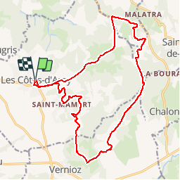
Randonnée V.T.T. de 20 km à découvrir à Auvergne-Rhône-Alpes, Isère, Les Côtes-d'Arey. Cette randonnée est proposée par marc6262.
Description
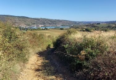
un beau parcours en foret retour par la route
La descente vers les cotes d'Arey sur la route est agréable (65 km/h) - possible de prendre un chemin
Localisation
Pays :
France
Région :
Auvergne-Rhône-Alpes
Département/Province :
Isère
Commune :
Les Côtes-d'Arey
Localité :
Unknown
Départ:(Dec)
Départ:(UTM)
646056 ; 5035347 (31T) N.
Commentaires
Randonnées à proximité
![Randonnée A pied Saint-Sorlin-de-Vienne - St Sorlin - chapelle St Michel - 8,3 km - 154 m de dénivelé - 2h30 - Photo](https://media.geolcdn.com/t/375/260/ext.jpg?maxdim=2&url=https%3A%2F%2Fstatic1.geolcdn.com%2Fsiteimages%2Fupload%2Ffiles%2F1545311037marcheuse_200dpi.jpg)
![A pied A pied](https://static1.geolcdn.com/sitytour/trail-icons/100.png)
St Sorlin - chapelle St Michel - 8,3 km - 154 m de dénivelé - 2h30
A pied
Facile
(1)
Saint-Sorlin-de-Vienne,
Auvergne-Rhône-Alpes,
Isère,
France
![](/images/other/stat-length.png)
8,3 km | 10,4 km-effort
2h 30min
![](https://static1.geolcdn.com/siteimages/upload/files/16400158638029165_repeat_loop_refresh_sync_direction_icon.png)
Oui
![Randonnée A pied Jardin - Jardin - 10,7 km - 255 m de dénivelé - 3h30 - Photo](https://media.geolcdn.com/t/375/260/ext.jpg?maxdim=2&url=https%3A%2F%2Fstatic1.geolcdn.com%2Fsiteimages%2Fupload%2Ffiles%2F1545311037marcheuse_200dpi.jpg)
![A pied A pied](https://static1.geolcdn.com/sitytour/trail-icons/100.png)
Jardin - 10,7 km - 255 m de dénivelé - 3h30
A pied
Moyen
(1)
Jardin,
Auvergne-Rhône-Alpes,
Isère,
France
![](/images/other/stat-length.png)
10,7 km | 14,1 km-effort
3h 30min
![](https://static1.geolcdn.com/siteimages/upload/files/16400158638029165_repeat_loop_refresh_sync_direction_icon.png)
Oui
![Randonnée Marche Reventin-Vaugris - 38-reventin-10km-325m - Photo](https://media.geolcdn.com/t/375/260/4f43ff32-027d-445e-b925-188f68c95bae.jpg&format=jpg&maxdim=2)
![Marche Marche](https://static1.geolcdn.com/sitytour/trail-icons/101.png)
38-reventin-10km-325m
Marche
Facile
Reventin-Vaugris,
Auvergne-Rhône-Alpes,
Isère,
France
![](/images/other/stat-length.png)
10 km | 14,3 km-effort
3h 5min
![](https://static1.geolcdn.com/siteimages/upload/files/16400158638029165_repeat_loop_refresh_sync_direction_icon.png)
Oui
![Randonnée Marche Reventin-Vaugris - REVENTIN 18 JC - Photo](https://media.geolcdn.com/t/375/260/ext.jpg?maxdim=2&url=https%3A%2F%2Fstatic1.geolcdn.com%2Fsiteimages%2Fupload%2Ffiles%2F1553511878bg_sport_marche.png)
![Marche Marche](https://static1.geolcdn.com/sitytour/trail-icons/101.png)
REVENTIN 18 JC
Marche
Très facile
(1)
Reventin-Vaugris,
Auvergne-Rhône-Alpes,
Isère,
France
![](/images/other/stat-length.png)
7,3 km | 10,5 km-effort
2h 12min
![](https://static1.geolcdn.com/siteimages/upload/files/16400158638029165_repeat_loop_refresh_sync_direction_icon.png)
Oui
![Randonnée Marche Reventin-Vaugris - REVENTIN VAUGRIS 2 JC - Photo](https://media.geolcdn.com/t/375/260/ext.jpg?maxdim=2&url=https%3A%2F%2Fstatic1.geolcdn.com%2Fsiteimages%2Fupload%2Ffiles%2F1553511878bg_sport_marche.png)
![Marche Marche](https://static1.geolcdn.com/sitytour/trail-icons/101.png)
REVENTIN VAUGRIS 2 JC
Marche
Très facile
(1)
Reventin-Vaugris,
Auvergne-Rhône-Alpes,
Isère,
France
![](/images/other/stat-length.png)
12,9 km | 17,8 km-effort
3h 45min
![](https://static1.geolcdn.com/siteimages/upload/files/16400158638029165_repeat_loop_refresh_sync_direction_icon.png)
Oui
![Randonnée V.T.T. Reventin-Vaugris - Écureuil 2013 - Photo](https://media.geolcdn.com/t/375/260/ext.jpg?maxdim=2&url=https%3A%2F%2Fstatic1.geolcdn.com%2Fsiteimages%2Fupload%2Ffiles%2F1524743154velo.jpg)
![V.T.T. V.T.T.](https://static1.geolcdn.com/sitytour/trail-icons/202.png)
Écureuil 2013
V.T.T.
Difficile
(1)
Reventin-Vaugris,
Auvergne-Rhône-Alpes,
Isère,
France
![](/images/other/stat-length.png)
30 km | 40 km-effort
2h 34min
![](https://static1.geolcdn.com/siteimages/upload/files/16400158638029165_repeat_loop_refresh_sync_direction_icon.png)
Oui
![Randonnée A pied Vienne - Vossères - Croix des Chasseurs - fixme - Photo](https://media.geolcdn.com/t/375/260/ext.jpg?maxdim=2&url=https%3A%2F%2Fstatic1.geolcdn.com%2Fsiteimages%2Fupload%2Ffiles%2F1545311037marcheuse_200dpi.jpg)
![A pied A pied](https://static1.geolcdn.com/sitytour/trail-icons/100.png)
Vossères - Croix des Chasseurs - fixme
A pied
Facile
Vienne,
Auvergne-Rhône-Alpes,
Isère,
France
![](/images/other/stat-length.png)
4,4 km | 5,5 km-effort
1h 15min
![](https://static1.geolcdn.com/siteimages/upload/files/16400158638029165_repeat_loop_refresh_sync_direction_icon.png)
Non
![Randonnée Marche Reventin-Vaugris - Reventin - Photo](https://media.geolcdn.com/t/375/260/c3806f76-b895-481e-a817-a286e184dd44.jpg&format=jpg&maxdim=2)
![Marche Marche](https://static1.geolcdn.com/sitytour/trail-icons/101.png)
Reventin
Marche
Très facile
Reventin-Vaugris,
Auvergne-Rhône-Alpes,
Isère,
France
![](/images/other/stat-length.png)
2,7 km | 4,1 km-effort
45min
![](https://static1.geolcdn.com/siteimages/upload/files/16400158638029165_repeat_loop_refresh_sync_direction_icon.png)
Oui
![Randonnée A pied Chonas-l'Amballan - chonas l'amballan 7.3 - Photo](https://media.geolcdn.com/t/375/260/ext.jpg?maxdim=2&url=https%3A%2F%2Fstatic1.geolcdn.com%2Fsiteimages%2Fupload%2Ffiles%2F1545311037marcheuse_200dpi.jpg)
![A pied A pied](https://static1.geolcdn.com/sitytour/trail-icons/100.png)
chonas l'amballan 7.3
A pied
Facile
(1)
Chonas-l'Amballan,
Auvergne-Rhône-Alpes,
Isère,
France
![](/images/other/stat-length.png)
7,3 km | 10,5 km-effort
2h 23min
![](https://static1.geolcdn.com/siteimages/upload/files/16400158638029165_repeat_loop_refresh_sync_direction_icon.png)
Oui
Bon